
Status
On this page:
About the Future Planning Framework
We have worked with local councils from 2017 to develop Melbourne’s Future Planning Framework including 6 draft land use framework plans for the Melbourne Metropolitan regions.
As a key Plan Melbourne 2017-2050 implementation action, the plans will help guide how growth, jobs, housing, infrastructure, major transport improvements and open space are managed at a regional level over the next 30 years.
The purpose of the land use framework plans is to guide the application of Plan Melbourne’s 9 guiding principles, 7 outcomes, 32 directions and 90 policies at a regional and local level.
The 6 metropolitan regions are made up of 32 local government areas and each has its own unique draft plan. The draft land use framework plans set out how we will achieve the vision for each region under 6 key themes:
- productivity
- housing choice
- integrated transport
- liveability
- strong communities
- sustainability and resilience.
The draft plans are a 30 year strategic vision that provides guidance on how we will:
- shape population and industry growth
- inform plans for services and infrastructure
- guide public and private sector investments such as Suburban Rail Loop
- protect the distinctive and historic characteristics of each region
- improve environmental resilience.
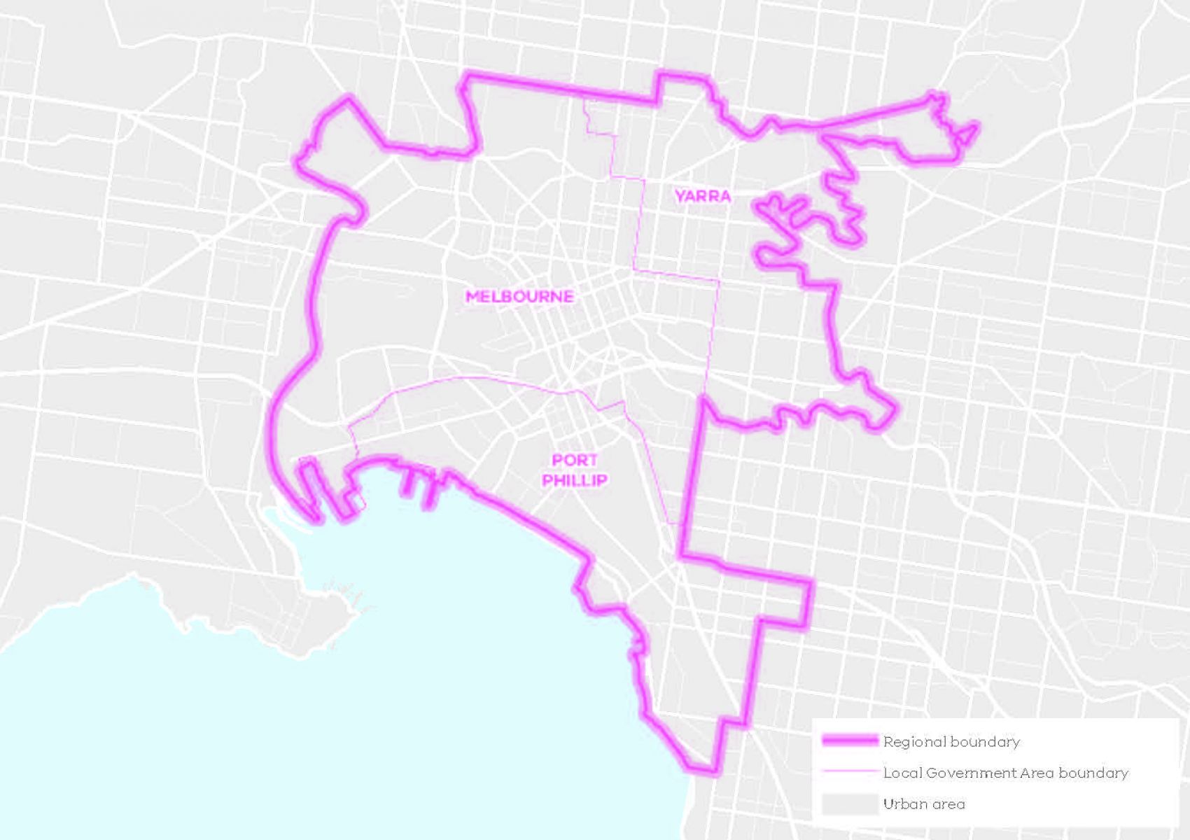
Inner metro region
The Inner metro region includes the Local Government Areas of:
- Melbourne
- Port Phillip
- Yarra.
The region contains Melbourne’s CBD, dense, established inner suburbs as well as Port Phillip Bay beaches to the south, the Yarra River (Birrarung) traversing through the region and the Maribyrnong River to the west.
It is identified as the hub of metropolitan Melbourne and the State of Victoria, supported by significant infrastructure investment. It is now the historic heart of Melbourne’s civic, political and economic life. The Inner Metro region is also home to a high concentration of jobs, global business operations, a bustling 24-hour cultural life and world-class sporting, arts and cultural precincts.
Traditional Owner acknowledgement
We gratefully acknowledge the assistance provided by the Wurundjeri Woi-wurrung Cultural Heritage Aboriginal Corporation and the Bunurong Land Council Aboriginal Corporation in preparing the Inner Metro Region Land Use Framework Plan.
Consultation draft land use framework plan
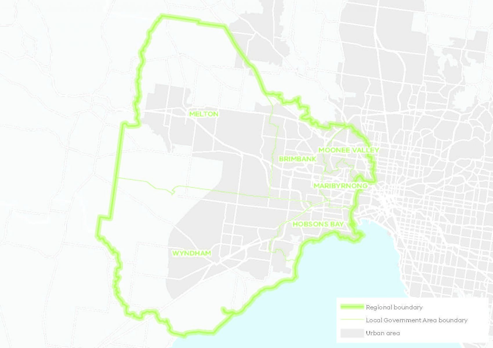
Western metro region
The Western metro region includes the Local Government Areas of:
- Brimbank
- Hobsons Bay
- Maribyrnong
- Melton
- Moonee Valley
- Wyndham.
The region sits on the Victorian Volcanic Plain and its natural environment is characterised by its extensive southern coastline, sweeping plains, a network of waterways and protected grasslands with significant biodiversity values. It includes the growth areas of Wyndham and Melton, extensive industrial areas and Melbourne’s vibrant inner western suburbs.
Traditional Owner acknowledgement
We gratefully acknowledge the assistance provided by the Wadawurrung Traditional Owners Aboriginal Corporation, the Bunurong Land Council Aboriginal Corporation and the Wurundjeri Woi-wurrung Cultural Heritage Aboriginal Corporation in preparing the Western Metro Region Land Use Framework Plan.
Consultation draft land use framework plan
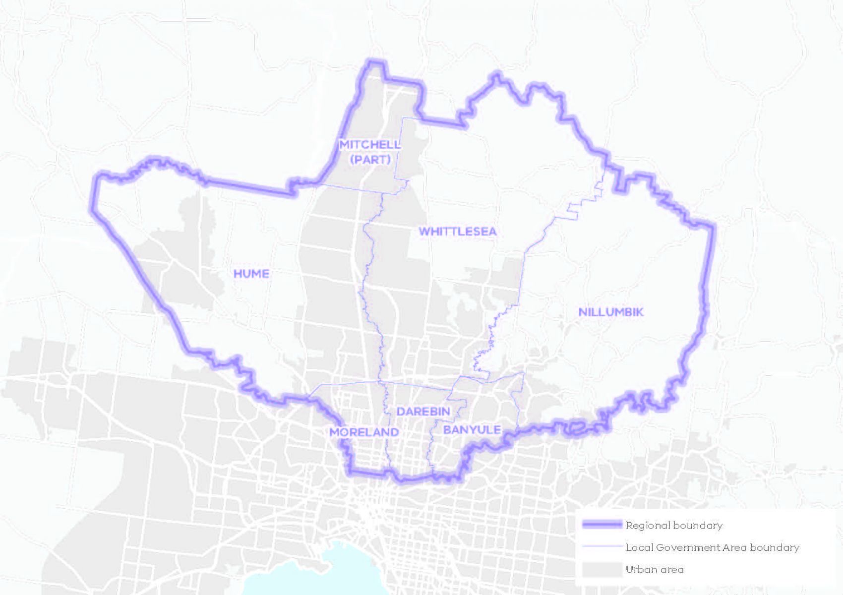
Northern metro region
The Northern metro region includes the Local Government Areas of:
- Banyule
- Darebin
- Hume
- Mitchell
- Merri-bek
- Nillumbik
- Whittlesea.
The region extends from the inner suburbs of Brunswick, Coburg, Preston, Northcote, Heidelberg and Ivanhoe to some of the city’s newest communities in Sunbury, Craigieburn, Mernda and Wallan.
Traditional Owner acknowledgement
We gratefully acknowledge the assistance provided by the Wurundjeri Woi-wurrung Cultural Heritage Aboriginal Corporation in preparing the Northern Metro Region Land Use Framework Plan.
Consultation draft land use framework plan
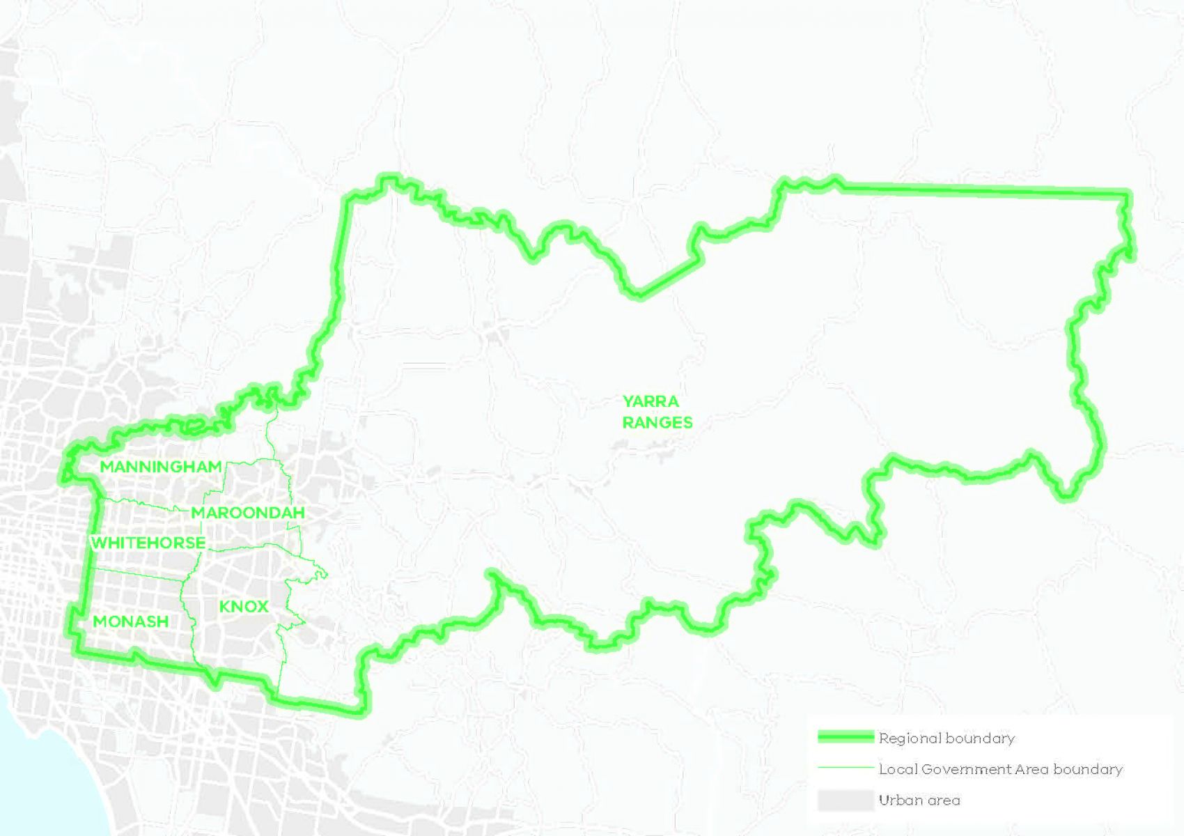
Eastern metro region
The Eastern Metro region includes the Local Government Areas of:
- Knox
- Manningham
- Maroondah
- Monash
- Whitehorse
- Yarra Ranges.
The region is defined by its undulating landscape, established and well-treed neighbourhoods, extensive parklands, boulevards, green wedge land and rural townships.
Traditional Owner acknowledgement
We gratefully acknowledge the assistance provided by the Wurundjeri Woi-wurrung Cultural Heritage Aboriginal Corporation, the Taungurung Land and Waters Council and the Bunurong Land Council Aboriginal Corporation in preparing the Eastern Metro Region Land Use Framework Plan.
Consultation draft land use framework plan
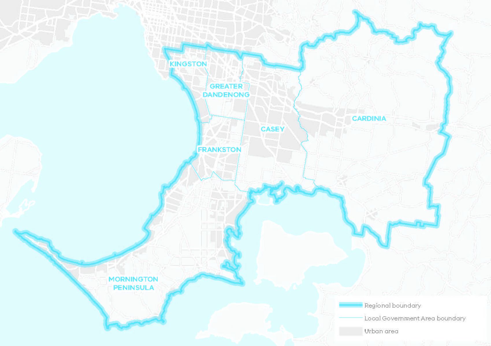
Southern metro region
The Southern Metro region includes the Local Government Areas of:
- Cardinia
- Casey
- Frankston
- Greater Dandenong
- Kingston
- Mornington Peninsula.
The region extends southwards from the middle suburbs of Moorabbin, Mentone, Springvale and Dandenong to Port Phillip and Western Port bays, encompassing the Mornington Peninsula, and eastwards to Bunyip beyond the Dandenong Ranges. It contains a total of 236 km of coastline along Port Phillip Bay and Western Port.
Traditional Owner acknowledgement
We gratefully acknowledge the assistance provided by the Wurundjeri Woi-wurrung Cultural Heritage Aboriginal Corporation and the Bunurong Land Council Aboriginal Corporation in preparing the Southern Metro Region Land Use Framework Plan.
Consultation draft land use framework plan
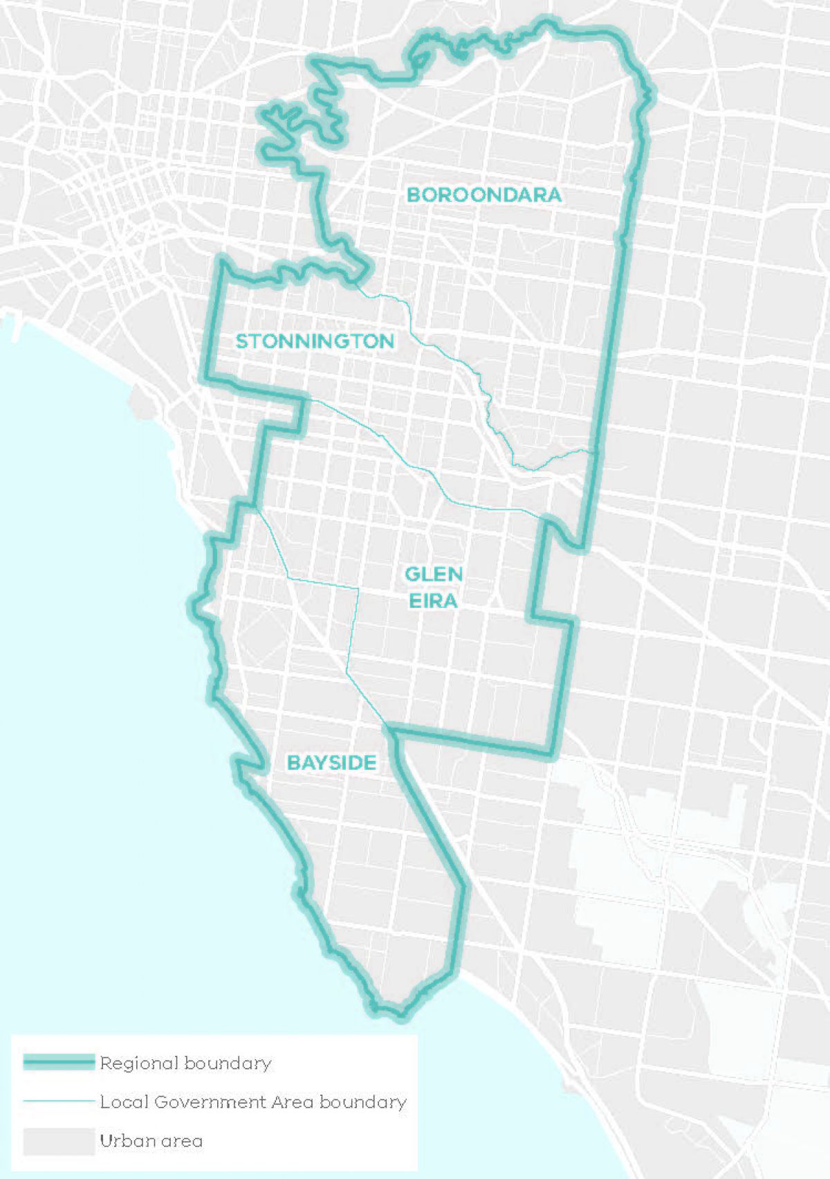
Inner South East metro region
The Inner South East metro region includes the Local Government Areas of:
- Bayside
- Boroondara
- Glen Eira
- Stonnington.
Though the region is the second smallest of all 6 land use framework plans, it is one of the most prosperous, with some of the city’s highest land values and a greater proportion of residents being professional workers. This is driven by the region’s strong access to Melbourne’s CBD where most professional jobs are located and its established, high amenity neighbourhoods.
Traditional Owner acknowledgement
We gratefully acknowledge the assistance provided by the Wurundjeri Woi-wurrung Cultural Heritage Aboriginal Corporation and the Bunurong Land Council Aboriginal Corporation in preparing the Inner South East Metro Region Land Use Framework Plan.
Consultation draft land use framework plan
Aboriginal self-determination
Pupangarli Marnmarnepu - Wadi Wadi and Mutti Mutti language for ‘Owning Our Future’ - is the Victorian Government’s Aboriginal Self-Determination Reform Strategy 2020-2025.
Pupangarli Marnmarnepu forms the basis of an ongoing dialogue and partnership with Traditional Owners to influence metropolitan planning and the implementation of Plan Melbourne 2017-2050 in each of the 6 metropolitan regions. It will also provide the foundation for further discussions with Traditional Owners on achieving self-determination through the planning system into the future.
Next steps
Following consultation in 2021, the draft plans are being updated for consideration by the Minister for Planning.
Page last updated: 13/11/24