How train and tram zone activity centres were identified
The Department of Transport and Planning identified the centres by analysing transport capacity, market viability, access to jobs and services, and environmental considerations.
The identification of train and tram zone activity centres near train stations or tram corridors follows community feedback during consultation for the Activity Centres Pilot Program, where we heard that people want more homes near public transport.
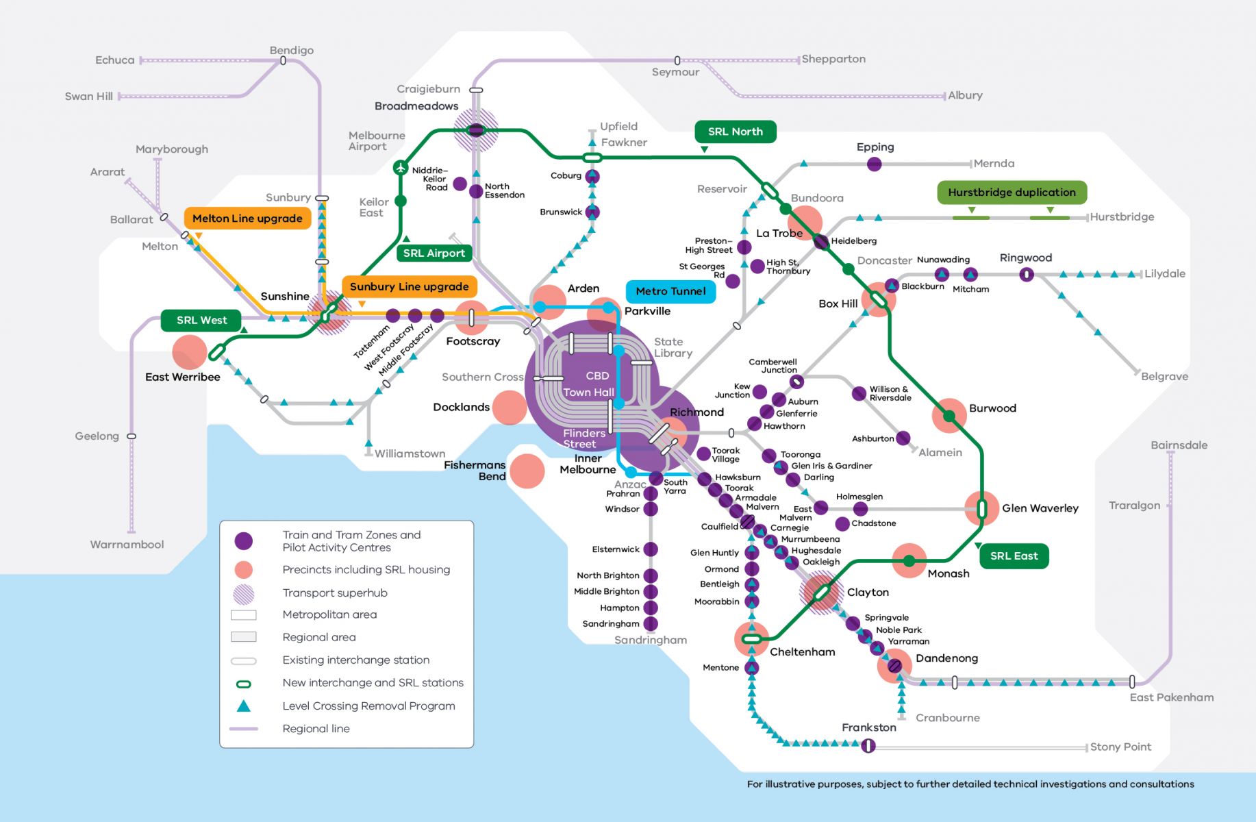
See the map below of all the train and tram zone activity centre locations:
Map of train and tram zone activity centres
Planning for new homes in Melbourne
Every neighbourhood has its own unique character shaped by its streetscapes, buildings, parks and the way people move through them. Train and tram zone activity centre plans help guide where new homes can go and what kind of homes are most suitable for each area.
The plans include clear planning rules, such as building heights and setbacks, providing certainty for council, communities and developers alike.
We followed an established process for developing planning controls for each train and tram zone activity centre. This included looking at the existing buildings, how the land is currently used, transport links and infrastructure.
Plans for all 60 train and tram zone activity centres are now in place. You can find the plan for your centre by searching the Resource Library.
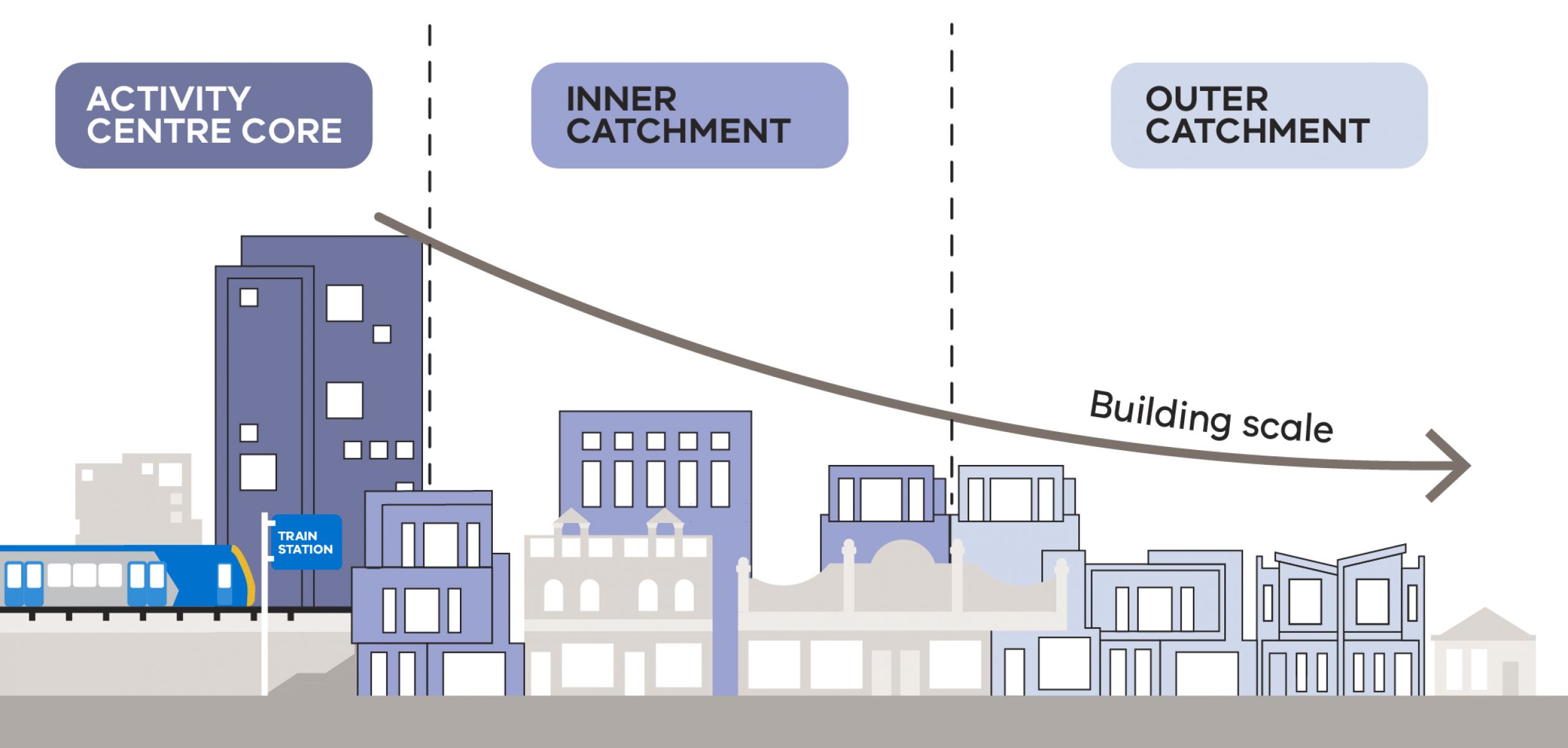
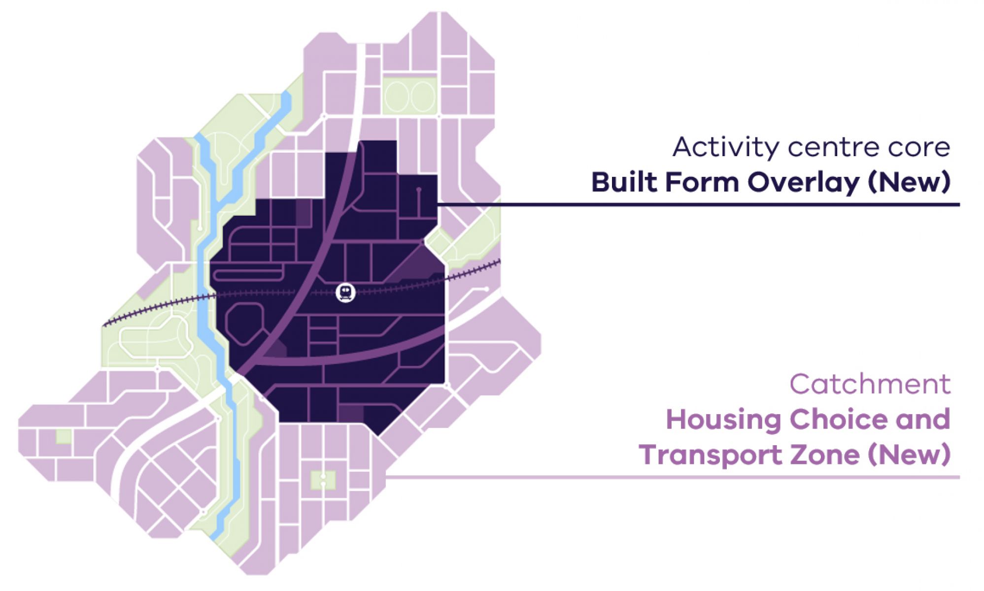
Most train and tram zone activity centre plans include a ‘core’ and a ‘catchment’ area. Some have an ‘inner’ and ‘outer’ catchment area.
Core
Inner catchment
Outer catchment
Various heights between six and 16 storeys in most centres, with potential for taller heights in some places in the larger centres
Up to four storeys, and up to six storeys on blocks larger than 1000m2
Up to three storeys, and up to four storeys on blocks larger than 1000m2
The core is the central part of the train and tram zone activity centre, closest to public transport, jobs and services. This area is best suited to accommodate more homes.
The catchment is the surrounding area within approximately 10 minutes’ walk of the core (around 800 metres).
As you move away from the commercial and community core of the train and tram zone activity centre,the proposed building heights will gradually decrease. This will allow a transition between the activity centre and the surrounding suburb.
New planning tools
There are two new planning tools that support the delivery of train and tram zone activity centres.
A new Built Form Overlay (BFO) has been developed to make planning controls in activity centre ‘cores’ clearer and more consistent across Melbourne.
The overlay sets out design rules to guide:
building heights and setbacks from the street between neighbours
overshadowing (sun protection requirements)
street activation, pedestrian connectivity and weather protection
what master plans for larger sites should include. For example: tree retention, how people can walk through the site, car and bike parking and access, and improvements to public areas
landscaping requirements
sustainable design assessment requiremens and other planning considerations.
The new Housing Choice and Transport Zone (HCTZ) has been developed to enable a diversity of housing in the catchments, and other well-serviced locations with convenient access to public transport, jobs and services.
Catchment areas allow for the types of townhouses and smaller apartment buildings these reforms are designed to support.
Find out more about what standards residential development in the HCTZ should meet to ensure good design including overshadowing, setbacks and tree planting:
A new streamlined process for planning applications for good quality developments in train and tram zone activity centre cores has been implemented.
Under this new process, if an application meets the 'deemed to comply' standards within the BFO, it cannot be refused a permit on the basis of those standards.
In addition, applications for most new buildings within the BFO are not subject to a public notice period. This means council does not need to notify nearby landowners about the planning application or consider objections. If notice and review is required under another part of the planning scheme, those provisions will continue to apply.
This approach to notice and review provisions is not new – similar exemptions exist in other key parts of Victoria.
The streamlined process will encourage:
faster application processing
greater certainty about application outcomes
time and money saved in holding costs
reducing costly VCAT hearings.
Councils will remain the responsible authority for planning applications and permits in most cases.
The new Built Form Overlay (BFO) streamlines planning controls in the ‘cores’ and sets out ‘deemed to comply’ building heights and design rules. It also applies a new streamlined planning pathway to allow more homes to be built faster.
In the core, under the BFO, there will likely be no third-party notice and review related to matters such as heights and setbacks (however, there are often other triggers for notice in the planning scheme).
The responsible authority will still consider relevant building design matters in granting a permit. This includes having regard to the relevant council’s planning scheme, including local policy, and any other relevant provisions.
In areas where the Housing Choice and Transport Zone (HCTZ) has been applied, notice and review requirements depend on the provisions of the residential development codes. In most cases, notice requirements remain.
These new planning tools make it easier for councils to encourage more homes to be built close to public transport, jobs and services in their own municipalities.
For developments that involve two or more dwellings on a lot up to three storeys, the Townhouse and Low-Rise Code applies. For development of two or more dwellings on a lot between four to six storeys, the Mid-Rise Code applies.
These codes require developers to meet a range of requirements such as street setbacks, tree canopy, front fences, access and coverage. They also include a streamlined 'deemed to comply' planning pathway for compliant developments, allowing for faster permits and greater certainty.
Maintaining heritage
We understand the importance of maintaining the heritage of certain train and tram zone activity centres. The new planning controls do not change existing heritage overlays in these centres.
Heritage overlays and considerations for housing growth guide decision-makers on what development is appropriate. Planning decisions in activity centres will need to balance heritage protection with the need for diverse housing and councils will continue to assess planning permits as part of this process.
Funding new infrastructure
A new, simpler and more flexible infrastructure funding system will help deliver essential infrastructure. This may include things such as community services, education and transport infrastructure.
Flood risk is generally not a barrier to building more homes. Except for in very high hazard areas, development of new housing can still occur and will be informed by better guidance on how to design and plan flood-resilient development.
The Department of Transport and Planning is working with the relevant authorities to prepare new guidance on how to appropriately build in areas subject to flooding. Melbourne Water is updating its flood modelling to provide more in-depth information about known hazards. When finalised, this information will be used by councils in conjunction with activity centre controls when approving permits for housing in areas subject to flooding.
New flood risk ratings and better flood risk information will help landowners and industry understand what housing can be built where and how.
For more information about Melbourne Water’s flood modelling work, visit the Melbourne Water website.