
On this page:
About urban structure
Urban structure comprises the overall topography and land division pattern of an urban area. It is the pattern and scale of blocks, lots and public spaces, and the arrangement and scale of the movement network's streets, roads and paths. Whether at the scale of a city, town, neighbourhood, precinct or large development site, it is the interrelationship between all of the elements of urban structure, rather than their individual characteristics, that together make a place.
Urban structure includes the location and types of activity centres, public transport nodes and corridors, public spaces, community facilities, and urban infrastructure.
Whether at the scale of a city, town, neighbourhood, precinct or large development site, it is the interrelationship between the elements of urban structure, rather than their individual characteristics, that together make a place. Urban structure includes:
- the location and types of activity centres
- public transport nodes and corridors
- public spaces
- community facilities
- urban infrastructure.
Why is it important?
The urban structure determines:
- the serviceability and flexibility of an urban area
- how well it integrates with its surroundings.
The urban structure contributes to an area's function and feel and creates a sense of place.
A well functioning urban structure has connected neighbourhoods, where activity centres are within convenient walking distance. Urban structure design can enhance personal safety and property security by allowing for informal surveillance opportunities and a choice of routes.
The layout of blocks and lots can support or limit flexibility, diversity and opportunity in a city or neighbourhood. It also influences the types of buildings and land uses that can be accommodated, for example:
- Large blocks might permit a wider variety of development options but can pose a barrier to movement
- Smaller blocks allow greater ease and choice of movement around a neighbourhood.
Principles
General principles for the arrangement of:
- streets
- paths
- blocks and lots
- public open spaces
- activity centres
- public transport nodes
- corridors and residential neighbourhoods.
These urban structure principles apply to the design of:
- activity centres
- large development sites
- higher density residential precincts
- the public realm.
Use the urban structure principles in conjunction with accepted civil design standards for motor vehicle movement, and water management.
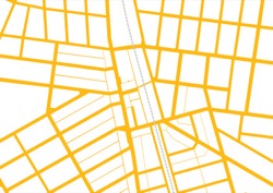
Objective 1.1.1: provide a permeable and functional urban structure of blocks and streets
Permeability refers to the extent to which the urban structure permits, or restricts, the movement of people or vehicles through an area, and the capacity of the area network to carry people or vehicles.
- Create an interconnected street layout with regular block sizes.

Tip: an interconnected street layout provides a choice of routes, allowing people to move about and transport goods easily and efficiently. - Create a permeable block layout with block dimensions ranging from 120 m to 240 m long and 60 m to 120 m wide.
Tip: a block perimeter of around 600 m provides for good pedestrian and vehicular access and an efficient subdivision pattern of the block. Smaller blocks may be appropriate in more intense urban areas.
- Extend streets, pedestrian and bicycle paths from existing areas into new areas with direct roads, streets and paths.
- Align pedestrian connections along desire–lines with short, straight travel paths.
Tip: people generally choose the shortest practical path to their destination. Curving street alignments can increase pedestrian and cycling distances, and reduce sightlines. However, in sloping topography, curving streets may be more appropriate to enable flatter travel paths.
Objective 1.1.2: provide a legible urban structure of blocks and streets
The legibility of an area refers to the ease with which a person is able to find their way around and navigate through the area.
- Lay out street and block patterns with direct, straight or near–straight streets.
Tip: areas with straight streets and clear sightlines are easier to navigate and safer for pedestrians. Tight curving streets can reduce neighbourhood legibility and be more difficult to develop and service. - Use the area’s topography, slope and contours to achieve an accessible movement network.
Tip: Curving street alignments may increase pedestrian and cycling distances, and reduce sightlines. However, in sloping topography, curving streets may be more appropriate to enable flatter travel paths. - Lay out street and block patterns to create view lines to key landmarks.

Tip: Highly visible landmarks and landscape features aid navigation and way–finding as well as contribute to a sense of place. - Where a cul-de-sac is necessary, limit the length to less than 75 m, with a straight alignment or clear sightlines to the end
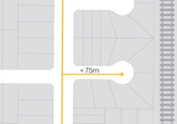
Tip: A short cul-de-sac allows views from the adjoining street to the cul-de-sac end.
Objective 1.1.3: ensure the urban structure supports accessibility from neighbourhoods to activity centres and public transport
- Lay out streets and blocks to provide reasonable walking distances from dwellings to an activity centre and public transport services.
Tip: a 400 m (or 5 minute) street walking distance to an activity centre provides good accessibility for lots intended for medium and higher density residential uses.
- Create a street and block layout where 95 per cent of dwellings are located no more than:
- 400 m street walking distance from the nearest existing or proposed bus stop, or
- 600 m street walking distance from the nearest existing or proposed tram stop, or
- 800 m street walking distance from the nearest existing or proposed railway station
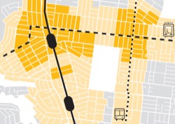
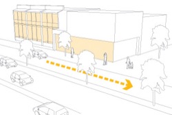
Tip: 400 m is about a 5 minute walk; 600 m is about a 7 minute walk; 800 m is about a 10 minute walk. - Provide continuous, direct pedestrian and bicycle access routes from the surrounding neighbourhood to railway stations and public transport stops and interchanges and activity centres.
Tip: pedestrian and bicycle access routes to a public transport node or activity centre should accommodate both public transport users and others moving around the neighbourhood. More people using the paths will create a safer environment.
Objective 1.1.4: ensure that the urban structure provides good amenity and safe interfaces between infrastructure corridors and adjacent land uses
- Locate major infrastructure corridors and installations to minimise their potential to be a barrier to cross movement.
Tip: infrastructure corridors such as railway lines, motorways and pipe tracks can be barriers to crossing but may provide opportunities for parallel linear parks and paths.
- Provide conveniently located grade separated pedestrian and bicycle crossings across rail corridors, motorways and other natural barriers, to connect neighbourhoods and key destinations.
Tip: in urban areas, the crossing location and frequency should be informed by local circumstances and need.
- Where a freight railway or motorway corridor interfaces with lots for residential or other sensitive uses, locate the rear boundary of lots toward the corridor.
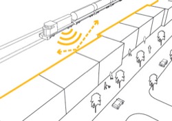
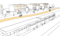
Tip: locating the rear boundaries of lots toward a freight railway or motorway corridor interface provides better opportunities for noise mitigation where relevant. - Where a railway operating corridor serves only metropolitan passenger services, provide a street between the railway operating corridor and the surrounding area, to provide an active frontage.
Tip: a street is not an effective noise buffer, but metropolitan services are generally of lesser noise impact than diesel freight trains. - Where lots adjoin high volume or high speed major roads, provide a service road and front lots on to the service road.
Tip: avoid block layouts where lots back onto arterial or major roads. This results in poor pedestrian safety and landscape amenity along the road.
Page last updated: 19/06/23