
On this page:
Importance of signs and way-finding in urban design
Signs give information about:
- way finding
- directions
- place and street names
- cultural identity
- buildings
- uses and activities
- advertising products.
They can also act as a landmark. Signs may vary in scale and appearance, and may use maps, text, images or symbols to convey information.
These guidelines focus on designing and locating signs in the public realm, particularly for pedestrians and cyclists.
6.6.1: ensure signs inform pedestrians and cyclists and aid way finding
Road signs are often designed to inform drivers. However, pedestrians and cyclists may find information on road signs misleading or unintelligible.
It is important to provide useful signage to people on foot or bicycle.
- Provide maps and signs in public spaces showing connections and destinations, and the location of public facilities and public transport routes.
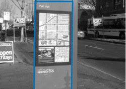
Tip: maps and signs are particularly important in large public open spaces where there may be few other visual cues for locations. - Provide clear and regular sign posting on main pedestrian routes.
- Concentrate pedestrian signs at node points on the pedestrian routes.
- Position signs clear of pedestrian and bicycle spaces and paths.
Tip: incremental installation of signs can encroach on and obstruct paths, and clutter public spaces.
- Position signs clear of vegetation.
- Place pedestrian and cyclist signs at user eye level.
Tip: many streets signs are designed and located for driver information, elevated above pedestrian eye height.
- Locate property street numbers to be visible from the street, day and night.
6.6.2: ensure signs contribute to the amenity and local character of an area
- Scale advertising signs to be consistent with the surrounding urban context.
Tip: large signs can impede sightlines and views. Refer to detailed guidance in the Victoria Planning Provisions clause 52.05 Advertising signs.
- Consolidate multiple messages into a single sign.

- Provide vandal-proof and graffiti-resistant signs.
6.6.3: ensure signs can be read and understood
- Orient perspective maps to be consistent with the viewer’s position, orient plan view maps with north at the top.

- Provide walking times or distance information to major destinations and facilities.
- Provide operating hours information at entrances to public areas.
- Illuminate signs in areas used at night.
- Use strong colours, clear contrasts, non-reflective surfaces and simple graphics on maps.
- Where the audience may not read English, use alternative communication methods to indicate pedestrian paths and destinations.
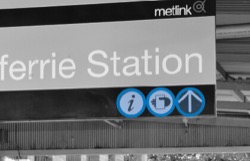
Tip: international symbols, paving markings or changes in paving surfaces and materials are useful to indicate different paths, destinations and intended use, particularly for people who do not read English or have vision impairment.
6.6.4: ensure sensitive uses adjacent to illuminated signage are protected from light spill
- Where a sign is illuminated, shield light spill to adjacent sensitive uses.
Tip: illuminated signs can cause glare and dazzle viewers at night, and intrude into sensitive uses.
6.6.5: manage the placement, currency and design of signs in public spaces
- Undertake a periodic review of signs in public spaces.
- Maintain up-to-date information on signs, and remove redundant signs.
- Implement processes to coordinate the design and placement of signs.
Tip: signs erected by diverse agencies can lead to inconsistent styles and clutter in public spaces.
Page last updated: 28/10/25