
On this page:
Principles
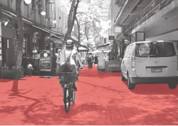
The movement network is the interconnected system of streets, roads and paths that accommodates pedestrians and cyclists, on-road public transport, emergency and private vehicles. The movement network connects places and activities, and allows people and goods to reach their intended destinations and to access private land.
Among its many functions, the movement network land area can provide space for utilities infrastructure and car parking, and can also provide access to daylight and ventilation for adjacent buildings. A well-functioning movement network provides optimal walking and cycling access to destinations such as activity centres, work, schools, public transport and parks, and it has high levels of legibility, convenience, amenity and safety for users.
Why is it important?
Good connections to places and linkages between different modes of transport, ensures equitable access to facilities, services and public transport. The design and layout of the movement network greatly affects people's mobility and travel options as well as their safety and wellbeing. Streets play an important role in enabling people to be more physically active and healthy. Streets also play an important role as public spaces, supporting social interaction and providing places for cultural expression.
These guidelines focus on urban design for active transport – pedestrians and cyclists and access to public transport. Provision for street design for vehicles is covered elsewhere by civil engineering standards.
2.1.1: ensure the movement network accommodates the diversity of transport modes and supports activities, including active transport
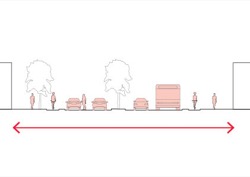
- Provide direct, continuous and well-lit pedestrian and bicycle routes.
- Provide a pedestrian network that caters for persons of all abilities.
- Provide for walking and cycling on all streets.
- Allocate a street function and mode priority to each street in the network.
Tip: SmartRoads, a tool for assigning priority to different modes of transport, was developed by VicRoads. It provides guiding principles for road use by transport mode, place of activity and time of day.
- Establish a level-of-service provision for each mode on each movement network section.
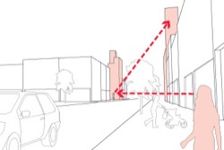
Tip: streets need to allocate sufficient space to accommodate the anticipated volume of pedestrians and cyclists as well as on-road public transport, vehicles and on- street car parking. For other modes see Guideline sources and references. - Maintain clear sight-lines to landmarks to assist pedestrians and cyclists to orient themselves and move around an area.
2.1.2: ensure the movement network provides for safe interactions between transport modes
- Provide clearly marked, direct and safe connections for pedestrians travelling between movement modes.
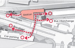
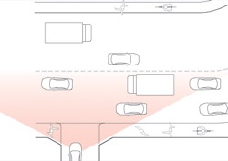
Tip: whenever people move between modes, such as between a parked car and public transport, they are pedestrians. - Arrange vehicle crossovers to allow clear sightlines between drivers entering the crossover and pedestrians and cyclists on the path.
2.1.3: maintain a safe, inclusive and serviceable movement network
- The movement network is managed by a number of agencies, each with different responsibilities and interests. This adds to the complexity of developing and managing a successful network.
- Manage the movement network and street space to respond to changes in use patterns and community needs.
Tip: the movement network can be managed by creating shared zones, vehicle lane controls, pedestrian-only periods, public transport priority periods, variable traffic light phases, parking controls, speed limits, and space for kerb cafés, street vendors and buskers. - Schedule periodic reviews of the movement network performance to inform network adjustments.
Page last updated: 28/10/25