
On this page:
Latest news
The digital transformation of Victoria’s planning schemes was completed in May 2023 with all major functions transitioned into the more accessible digital format in Planning Schemes Online (PSO).
The development of new features and updates in PSO have been driven by user feedback. Highlights include the replacement of over 11,000 PDF documents and approximately 80,000 pages of ordinance with fully digital content.
The information below provides an overview of the key functions in PSO.
Ordinance
Navigating a planning scheme
Planning schemes contain maps, ordinance and incorporated documents. Policies and written clauses are located in the ‘Ordinance’ tab, and the ‘Maps’ tab show where zones and overlays apply.
Find out more about planning schemes.
To navigate within a planning scheme, use the expandable menu on the left to reveal more or less clauses, sub-clauses and schedules.
Search within a planning scheme
Find a specific ordinance in a planning scheme by using the search feature, found in the top right of the planning scheme web page. You can search by:
- ordinance number, for example ‘11.01’
- keywords, for example ‘biodiversity’ or ‘bushfire’
- map code, such as DDO24 or HO23
- amendment number, such as C123 or VC148.
Search results show all instances of the search term used in the planning scheme.
Copy a clause, sub clause or schedule
Open the desired section and select the ‘Copy’ or ‘PDF’ option found next to the top title.
The PDF option will open a downloadable PDF version of the section open on screen. The Copy option will save the ordinance open on screen, you can then paste into a text editor such as Word or email.
View multiple sections at one time
To view more than one section at a time, open each new clause, sub-clause and schedule in a new browser tab.
To open in a new tab, right click the desired planning scheme section in the menu and select 'Open link in new tab'.
Maps
Using interactive maps
The interactive maps in planning schemes allow you to search for a property address, generate a planning property report or view planning controls.
Interactive maps are found in the 'Maps' tab for each planning scheme.
To search for a specific address, select the search icon available at the top left corner of the map, enter an address and select the correct address from the list of properties displayed.
The map will take you to the selected address. Planning scheme zones and map sheet numbers are displayed by default on the map.
View planning controls for a property
After searching for an address, view the planning controls applicable to the property by selecting the ‘Planning controls’ option in the property address pop-up.
A list of current policies for the property will be displayed on screen.
Select a policy to open it in a new browser tab.
View planning scheme overlays
To see planning scheme overlays, use the options displayed at the right of the map to tick ‘Planning scheme overlays’ then select the overlay types you want to view on the map.
You can add or remove any of the map layers in the menu as required.
Incorporated documents
A planning scheme may incorporate a document that relates to the use, development or protection of land. Incorporated documents may inform the planning scheme, guide decision making or affect the operation of the scheme.
An incorporated document is included in the list at clause 72.04 of the planning scheme. The document then forms part of and carries the same weight as other parts of the scheme and can only be changed by a planning scheme amendment.
View and search incorporated documents
After selecting a planning scheme, view its incorporated documents by selecting the ‘Incorporated documents’ tab.
The search functionality can be used to search by an amendment number or document name. Search results can be filtered by date of operation, status or document type such as state or local.
Amendments
Using planning scheme amendments
A change to a planning scheme map, the written part of the scheme, or both, is called an amendment.
After selecting a planning scheme, view its amendments by selecting the ‘Amendments’ tab.
The search functionality can be used to search by an amendment number or keyword. Search results can be filtered by last updated date or amendment type, status or outcome.
Browse all amendments
You can visit browse all amendments to search for and view details of amendments to all planning schemes
Histories
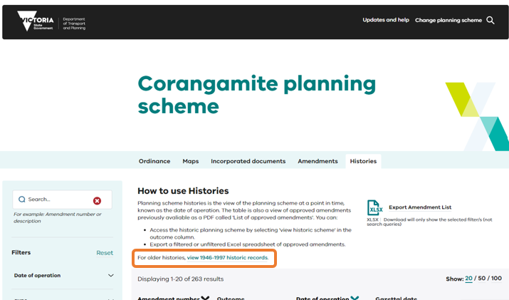
Using planning scheme histories
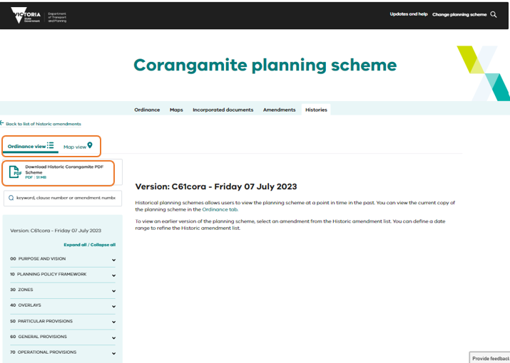
Planning scheme histories allow you to view a planning scheme (ordinance and maps) as it was at a previous point in time, i.e., date of operation.
After selecting a planning scheme, click on the ‘Histories’ tab to view a list of histories for the planning scheme. The list provides a summary of amendments that changed the planning scheme and the date it came into operation.
Select ‘View historic scheme’ from an amendment in the list to display the planning scheme at the point in time when the amendment became operational. To learn more about the planning scheme amendment that triggered the new history, select the amendment number from the list of histories.
Select ‘View ordinance’ to move to the Ordinance tab.
The first row in the list contains the current version of the planning scheme.
Planning scheme histories are available over three time periods:
Using planning schemes from 13 April 2022 onwards
Planning scheme histories from 13 April 2022 onwards are provided in a digital web (HTML) format.
- Ordinance and maps are available via the tabs and expandable menu.
- A combined PDF of the entire historic planning scheme is available above the ordinance navigation menu.
- After selecting an ordinance section, a PDF version can be opened or the text copied to paste into text editor such as Word or email.
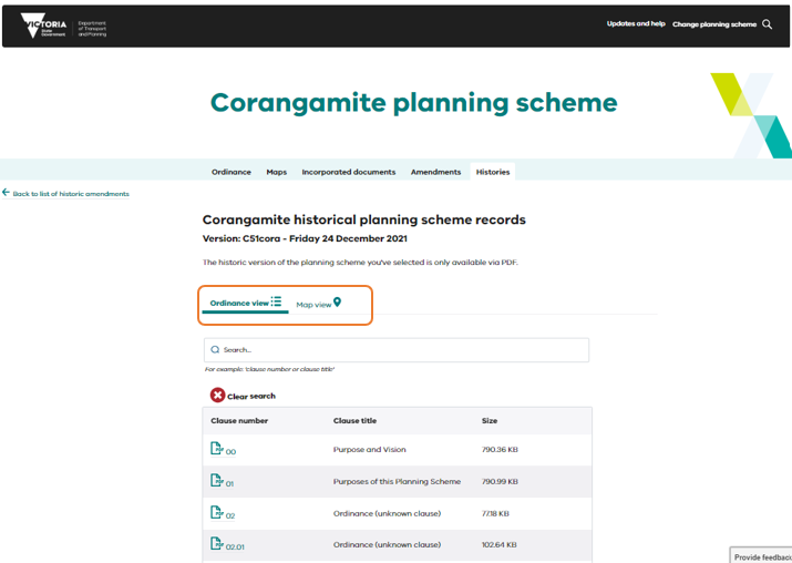
Accessing planning schemes from 1998 to 12 April 2022
In 1997, Victoria's 'new format' planning schemes (1997-2000) were introduced.
Planning scheme histories from 1 January 1998 to 12 April 2022 are available in a table with tabs to view ordinance or maps, these can also be viewed as a PDF.
Accessing planning scheme records from 1946 to 1997
Planning scheme records from 1946 to 1997 can be viewed at Public Record Office Victoria (PROV).
By selecting the link to view 1946 to 1997 historic records, you will be taken to the external PROV page that lists the content of series held by PROV with instructions on how to access the series information.
Time zone
Dates shown in planning schemes online are responsive to your time zone. For example, if you're viewing a planning scheme amendment that just became operational it would show an operational date of 01/01/2021, if accessed from Melbourne, Victoria [Australia Eastern Time (AET)]. However, if you viewed the same amendment from New York City (which is 14 hours behind AET) the date would show as 31/12/2020.
Page last updated: 29/08/24