
Status
On this page:
What is a settlement boundary?
A settlement boundary shows the intended limit of urban development for a township or metropolitan area in the planning scheme.
In Victoria there are three types of settlement boundaries:
- Urban Growth Boundary (UGB): Applies to metropolitan Melbourne’s fringe planning schemes, including the Mornington Peninsula through Part 3AA of the Planning and Environment Act 1987. The UGB, can only be changed by a majority vote in both houses of parliament.
- Protected Settlement Boundary (PSB): Applies to Distinctive Areas and Landscapes declared under section 3AAB of the Planning and Environment Act 1987 and specified in a Statement of Planning Policy (SPP). A PSB can only be changed through a resolution passed by both houses of parliament.
- Strategic Settlement Boundary (SSB): Applies to settlements in regional Victoria. It is shown on planning scheme maps but is not established in legislation. A planning scheme amendment is required to change an SSB.
All three types of settlement boundaries are shown on planning scheme maps and are included in VicPlan (the state-wide map viewer for planning schemes).
Why are settlement boundaries needed?
The purpose of a settlement boundary is to:
- Clearly define where urban development is supported and where it should stop
- Protect surrounding agricultural land, environmental values or significant landscapes
- Focus investments in infrastructure, services and housing within urban areas.
Plan for Victoria (Action 3) identifies the need to carefully manage the outward sprawl of regional cities and towns so they have compact urban forms and protect values beyond their boundaries, including natural resources, biodiversity, landscapes and agricultural land.
Clause 11.01-1S (Settlement) of the Planning Policy Framework provides policy support for this approach, seeking to manage the expansion of settlements by creating and reinforcing settlement boundaries.
A settlement boundary shown in a planning scheme map provides transparency to guide decision-making for planning scheme amendments and the approval of planning permit applications.
How can settlement boundaries be used?
Settlement boundaries can be used to:
- Prevent unmanaged growth that can cause loss of environmental and landscape values, inefficient infrastructure delivery, urban uses on rural land and loss of productive agricultural land.
- Avoid urban expansion into hazardous areas such as bushfire, flooding and erosion risk.
- Provide certainty for landowners, investors and authorities about where development will and will not occur.
The key benefits of applying settlement boundaries include:
- Preventing ‘ribbon’ or linear urban development, especially along the coast.
- Maintaining a non-urban break between settlements.
- Containing outward urban growth and safeguarding conservation areas, landscapes and productive agricultural land.
- Encouraging more compact and efficient settlements that make the most of existing infrastructure and services.
- Establishing defined areas for future housing and development, supporting long-term infrastructure planning.
- Reducing land use conflict at the urban–rural interface, such as with agricultural operations.
Setting a strategic settlement boundary
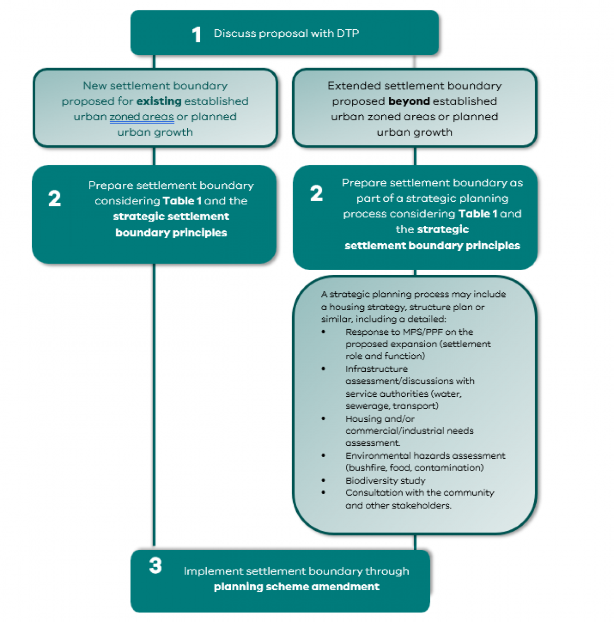
The methodology for setting a strategic settlement boundary should be applied consistently across all settlements. It provides a clear process to determine where urban growth is supported and where it should be limited.
The process should begin with the existing settlement, commonly defined by the existing zoning regime. Where zones already reflect established urban areas or planned urban growth, a strategic settlement boundary can usually be drawn around this extent without further strategic justification if future needs can be demonstrated and met.
A boundary that goes beyond existing zoned or identified urban land, must be supported by a clear strategic planning process such as a housing or township strategy or a structure plan. This ensures expansion is justified based on need, location, infrastructure capacity and broader settlement planning principles.
Before undertaking strategic planning work to set a strategic settlement boundary, councils should discuss the proposal with the Department of Transport and Planning.
Table 1 below specifies zones that typically apply inside or outside a strategic settlement boundary. The table also explains exceptions to the typical inclusions and exclusions.
Urban and township zones are generally included, while rural, environmental and resource zones are excluded. Long-term investigation areas should also be excluded until strategic planning confirms their role. Exceptions may apply where excluded zones lie within or traverse a settlement, or where including/excluding a zone produces a clearer and more enduring boundary.
Table 1 - Zones typically included and excluded in a strategic settlement boundary
| Included Zones Urban zones typically included in a settlement boundary | Excluded Zones Non-urban zones typically excluded from a settlement boundary |
|---|---|
Residential Zones:
| Rural Zones:
|
Commercial Zones: Commercial Zones (1, 2 and 3) | |
Industrial Zones: Industrial Zones (1, 2 and 3) | |
Public Land Zones:
| Public Land Zones: Public Conservation and Resource Zone |
Special Purpose Zones:
| Special Purpose Zones: Urban Floodway Zone |
| Exceptions | Exceptions |
When determining a settlement boundary, the following should be considered:
| A settlement boundary may include an excluded zone in the following instances:
|
Strategic settlement boundary principles
When considering setting or amending a strategic settlement boundary, including expanding a settlement beyond the current boundary, the following principles should guide strategically justified decision-making:
Growth planning and settlement role:
The expansion of the settlement should align with state, regional and local policy, and not challenge the established settlement hierarchy or result in an oversupply of urban land for the settlement or region.
Environmental risk management and adaptation:
Ensure expansion areas are free from significant natural hazards or include adequate measures to mitigate those hazards. Expansion areas must avoid the risk to life or property for the future population. Consider climate change adaptation and future risk profiles when including expansion areas.
Infrastructure and services:
Expansion areas must be supported by existing or planned infrastructure and provide access to essential services (schools, healthcare, transport). Land should be connected with existing urban areas to maximise the efficiency, integration and sustainability of infrastructure and services.
Housing and employment needs:
Expansion may be required to meet housing needs or targets, or to address shortfalls in commercial or industrial land. However, this should be balanced against environmental risk management and adaptation, as well as infrastructure and services availability.
Natural and landscape features:
Settlement planning should respond to natural boundaries (waterways, topography, coastlines, native vegetation) by creating logical and enduring settlement edges.
Land use conflict:
Settlement planning should avoid or minimise conflicts with surrounding agricultural, environmental or industrial activities by including sufficient buffers.
Implementing a strategic settlement boundary
A strategic settlement boundary is implemented in the planning scheme maps through a planning scheme amendment.
It should also be referenced in the Municipal Planning Strategy (and local planning policy, as needed) and reflected on relevant municipal strategic framework plans.
Existing settlement boundaries
Some planning schemes already include settlement boundaries from previous strategic work. Where inconsistently named, these settlement boundaries should be renamed to a ‘strategic settlement boundary’ and included in the planning scheme zone maps through a planning scheme amendment.
Any proposed change to the existing extent of a settlement boundary (expansion or reduction) should be determined by applying the strategic settlement boundary principles in this practice note and through the process outlined below.
The process for setting a strategic settlement boundary
Figure 1 sets out the process for implementing a strategic settlement boundary. It shows two pathways – one for proposals to establish a new boundary for an existing urban zoned area or planned growth area and another process for proposals to expand beyond an established urban zoned area or planned growth area. Both processes, illustrated below, require a response to Ministerial direction 11 – Strategic Assessment of Amendments as part of the planning scheme amendment process. The process for setting a strategic settlement boundary beyond established urban zoned areas requires more detailed justification.
Figure 1 - Setting a strategic settlement boundary
Page last updated: 09/04/26