
On this page:
Overview
Amendment VC277 implements our commitment under action 5 of Plan for Victoria, to match car parking rates with demand and reduce the number of car parks required in locations well-served by public transport.
We have updated the car parking rates in clause 52.06 (car parking) in the Victoria Planning Provisions (VPP) and all planning schemes.
Maps have been developed that align car parking rates with public transport access - Car Parking Requirement Maps (Department of Transport and Planning, December 2025).
The Car Parking Requirement Maps also support the introduction of minimum and maximum rates in areas with better public transport accessibility.
The public transport accessibility level (PTAL) methodology
The Car Parking Requirement Maps were developed using the Public Transport Accessibility Level (PTAL) methodology. The PTAL model for Victoria is a modified version of the methodology used interstate and internationally.
Developed in the United Kingdom and adapted for Victorian conditions, PTAL is a measure used in transport planning to assess how well a specific location is connected to the public transport network.
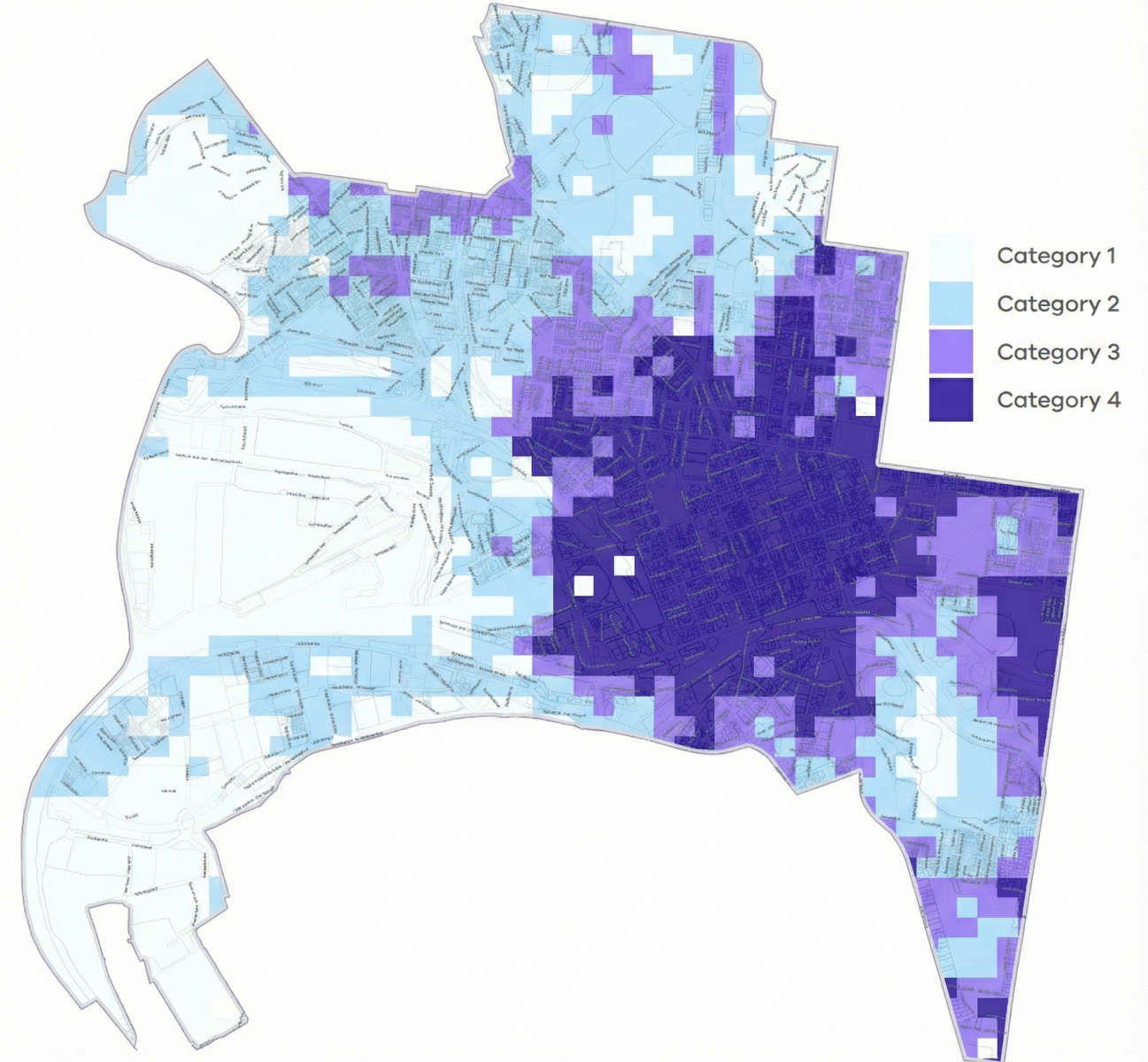
PTAL scores are determined by calculating walk times to public transport, type of public transport, public transport routes and timetabling data. The PTAL categories (category 1, 2, 3 and 4) are assigned based on the PTAL score for each grid and demonstrated visually in the Car Parking Requirement Maps.
Please refer to the PTAL fact sheet for more information about the PTAL methodology and development of the Car Parking Requirement Maps.
The maps will be monitored and reviewed on an annual basis.

- Car parking requirement map
Car parking requirement map
PTAL and car parking requirements
Clause 52.06 of the Victoria Planning Provisions contains car parking requirements for specified land uses.
The Car Parking Requirement Maps have four categories that are used to determine car parking requirements for a particular land use.
Category 1 areas have the lowest PTAL scores, and category 4 areas have the highest PTAL scores.
A location will have a higher PTAL score if:
- It is a short walking distance to the nearest stations or stops.
- Waiting times at the nearest stations or stops are short.
- More services stop at the nearest stations or stops.
- There are major rail stations nearby.
- Any combination of all the above.
A higher PTAL score results in a lower car parking requirement as connectivity to public transport is better. A location with a lower PTAL score (due to lesser public transport connectivity) will have a higher car parking requirement.
Checking car parking requirements
The Car Parking Requirement Maps are incorporated in the Victoria Planning Provisions at clause 72.04 and consist of 82 maps covering all metropolitan and regional municipalities.
VicPlan is our existing interactive mapping tool that includes a car parking requirement map layer. To view the category that affects your land, select the Car Parking Requirement Maps layer.
Principal public transport network (PPTN) area maps
PPTN area maps will continue to have an important role in informing strategic planning outcomes for transport, housing and density.
The PPTN will remain as an incorporated document in the VPP and all planning schemes.
Please refer to the Principal Public Transport Network for further information.
Page last updated: 18/12/25