Search for a planning property report

A planning report is a quick and simple summary of planning information for an address in Victoria.

What’s included

  • a planning zone map
  • separate maps for planning overlays affecting a property or parcel
  • links to the zone and overlay provisions in the local planning scheme
  • whether a property is included on the Victorian Heritage Register
  • whether the property is in a designated bushfire prone area
  • Melbourne strategic assessment area
  • areas of Aboriginal and cultural heritage sensitivity.

Search for a property report > see the result on screen > download the full property report (PDF) > View and intereactive map online

View an interactive map in VicPlan

VicPlan is an interactive map that provides location based zone and overlay information.

You can zoom and pan, and get easy access to a range of planning and property information across a larger area.

How VicPlan can help:

  • search for the planning information of a property, parcel or crown land
  • zoom interactively around the map to browse individual properties or an entire suburb
  • view aerial imagery for Victoria
  • draw on and mark-up the map
  • measure dimensions
  • apply a range of map layers
  • generate a Planning Property Report
  • create and build your own map
  • many other useful tools.

More information about VicPlan

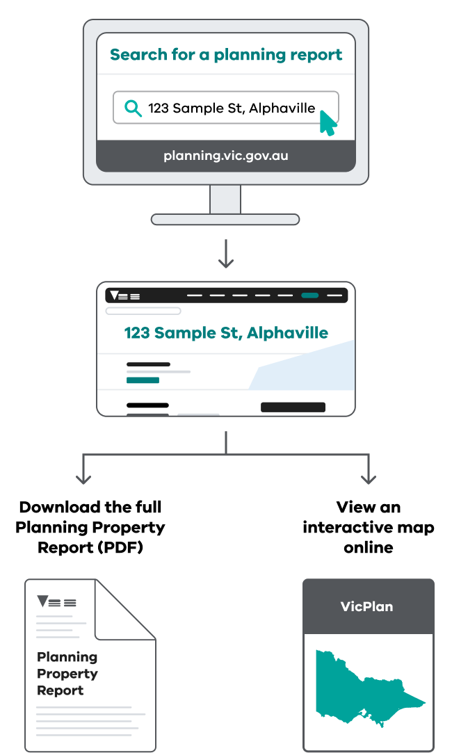
Enter the property address into the search above and choose the address you want search for.

This creates a planning property report for the address, with a summary of planning zones and overlays and other planning information. Select the zones or overlays to see details in the planning scheme.

You can download the planning property report as a PDF.

Yes, VicPlan is our state wide, interactive map for location based zone and overlay information.

You can search for the planning information of an individual property or zoom out to browse an entire suburb. You can generate a planning report, draw on and mark-up the map, measure dimensions, apply a range of map layers and access many other useful tools.

The Planning Report is designed for anyone who wants quick access to a summary of planning information about an individual property or land parcel. It’s perfect for those who already know the address of the property they are seeking information on.

VicPlan provides more comprehensive information on properties and the wider local government area. It’s interactive, so you can zoom and pan with ease, providing easy access to a range of planning and property information across a larger area.

Crown descriptions can be searched in the same way property and parcel descriptions are in the search bar. Although Crown land descriptions can be made up of numerous parts only a few of the main identifiers are needed to complete a search.

The main parts to a Crown land description are, Parish name, allotment number, section number, eg. Parish Ararat Allot 1 Sec 15A.

Crown descriptions can also include subdivision, portion and block numbers.A Crown land search will also display the corresponding lot and plan identifier in brackets after the Crown land descriptor, eg. Parish Ararat Allot 1 Sec 15A (1~15A\PP2020).