
New to practice notes?
Planning practice notes give technical advice about the planning system, each dealing with separate aspects of the system.
The purpose of this Planning Practice Note (PPN) is to provide guidance on how to consider planning permit applications close to waterways. It supports planners and applicants to consider how development may impact waterway health and corridor function.
It applies where an overlay control exists to protect a waterway, or when considering the Planning Policy Framework (PPF) for any other planning permit application close to a waterway.
Waterways and planning permit decisions
Waterways are significant environmental, cultural and landscape features that help shape the character and identity of places across Victoria. They are valued for their ecological health, biodiversity, amenity, recreational opportunities and the cultural connections they support, particularly for Traditional Owners.
Land use and development near waterways can have a direct and cumulative impact on the condition and function of these systems. Changes to vegetation, landform, built form and drainage patterns can affect water quality, stream stability, flood risk, biodiversity, cultural values and public access. As such, waterways are not just environmental assets, they are also critical infrastructure that support healthy, liveable and resilient communities.
Planning plays a key role in protecting the long-term integrity of waterway corridors by ensuring that planning permit applications for use or development near waterways are carefully considered and appropriately managed. Whether the proposal is for a dwelling, large subdivision or a change in land use, it is essential that potential impacts on waterways and their surrounding corridor are understood, and mitigated through good siting, design and management.
Assessing planning permit applications
Planning permit applications on land within or adjacent to a waterway corridor must be assessed against the relevant planning scheme provisions, including:
- the state planning policy in the PPF, particularly clause 12.03-1S (River and riparian corridors, waterways, lakes, wetlands and billabongs), unless exempted through a particular provision of the planning scheme
- zones and overlays that apply to the site
- relevant local planning policy in the PPF or strategic documents referenced in the planning scheme.
The overlays that typically apply to waterways include the following:
- Significant Landscape Overlay (SLO): Usually applied across a broad area to protect a waterway or waterway reach. May include permit requirements for buildings, earthworks, fencing or vegetation removal.
- Environmental Significance Overlay (ESO): Applied at a broad scale or to a localised place to protect biodiversity values. May include permit requirements for buildings, earthworks, fencing, vegetation removal, bicycle paths or subdivision.
- Design and Development Overlay (DDO): Applied to a local area or site to manage built form or protect views. May include permit requirements for buildings, earthworks, fencing, vegetation removal, subdivision or signage.
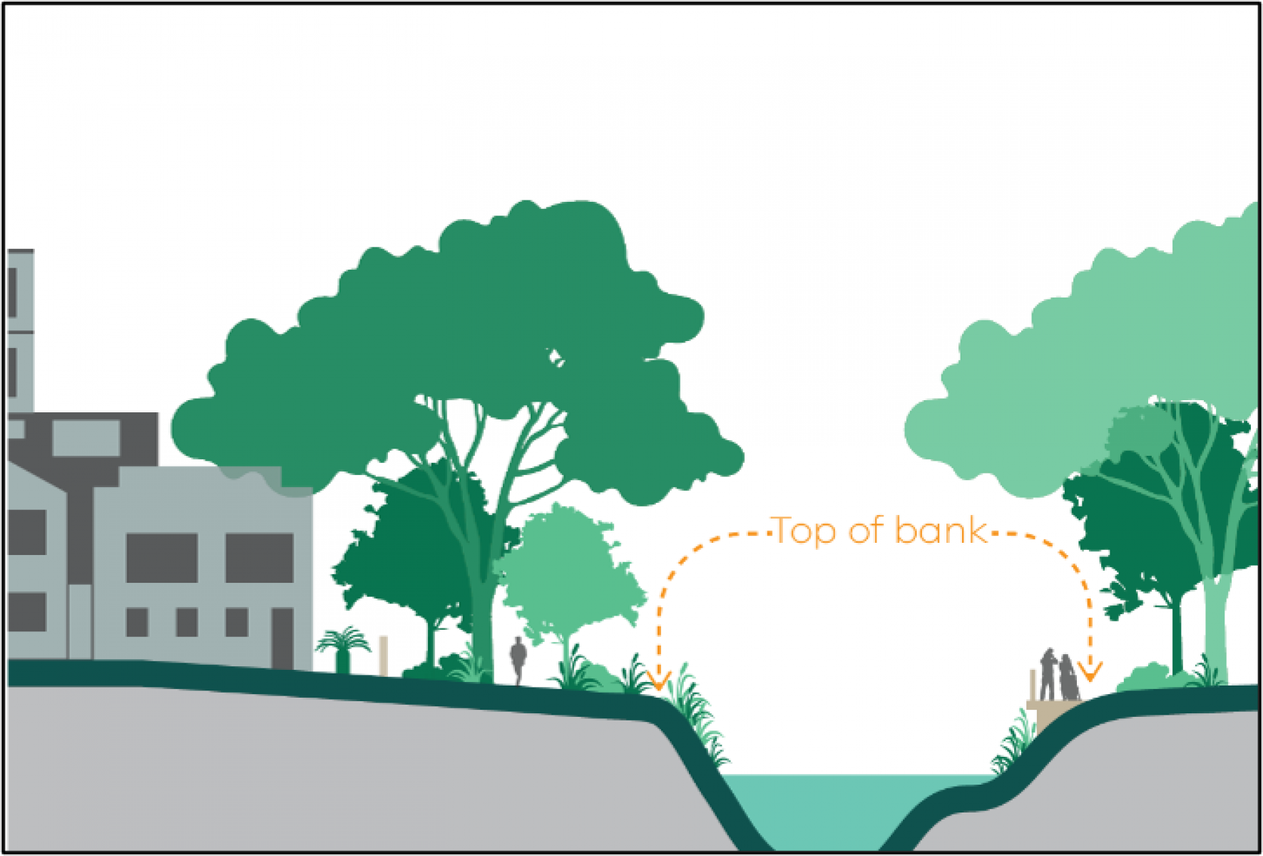
What does it mean to be close to a waterway?
The influence of waterways extends beyond their banks. For planning purposes, several spatial areas of a waterway and its surrounds should be considered/may be relevant:
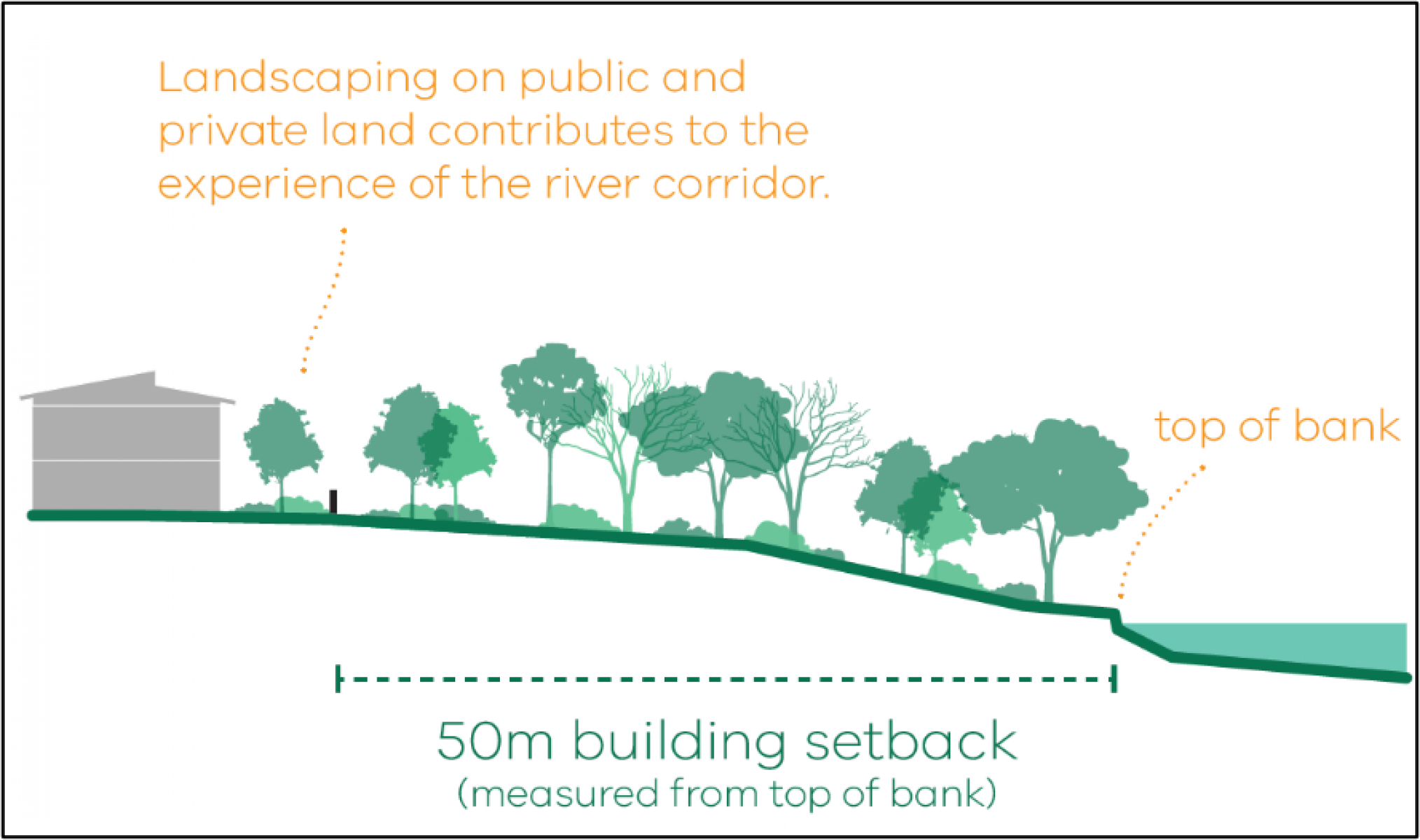
- Within 50m of the top of the bank: This area is generally kept free from development and earthworks. It plays a critical role in maintaining natural drainage patterns, supporting habitat and preserving the natural landscape character.
- Within 200m of the waterway centreline: Development in this broader area can still impact environmental, landscape and floodplain functions, as well as cultural heritage and visual values. Proposals here should consider how they interact with the waterway and its setting.
- Within 1km of the Birrarung corridor: Land within 1 km of the Birrarung’s banks (except land exempted under the Yarra River Protection (Wilip-gin Birrarung murron) Act 2017 is part of a formally recognised corridor. Planning decisions in this corridor must respond to its exceptional environmental, cultural and landscape values.
Assessing impacts to waterways
Planning permit assessment should consider not only the immediate, site-specific impacts of development, but also its contribution to cumulative pressures on waterways, such as:
- stormwater runoff
- vegetation removal
- corridor fragmentation
- encroachment into natural systems
- amenity loss or degradation.
Even small-scale developments can contribute to long-term cumulative degradation if not managed appropriately. Key issues that may need to be assessed include flooding, drainage, biodiversity, landscape values, amenity, cultural heritage, recreation and community access.
How development can impact waterways
Poorly designed development can alter hydrology, increase erosion, sodic soils and runoff, or impact riparian vegetation and public access. To minimise negative impacts, planning should encourage development that:
- minimises stormwater, pollution, nutrients and sediments through integrated water management
- avoids soil erosion and stabilises exposed surfaces
- limits overshadowing of significant vegetation and public areas
- maintains views to and from the waterway
- supports planting and protection of indigenous vegetation
- retains natural floodplain and flow paths.
New development should also be designed to avoid visual intrusion or dominance. Overshadowing, lighting, noise and glare should be managed through thoughtful site layout and use of appropriate materials and finishes.
Climate change projections should be factored into site planning, especially when considering flooding and vegetation resilience.

Specific impact considerations
Earthworks
Major earthworks near waterways can destabilise banks, contribute to erosion, and pollute downstream areas.
- Applications involving more than 600mm of cut or fill should assess potential adverse and cumulative impacts.
Floor area
New buildings that increase impermeable surface can affect drainage and amenity.
- Consider the cumulative effect of developments that increase floor area by more than 50square metres.
Building height
Excessive building height may result in overshadowing or dominate the natural landscape.
- Building height should be measured from natural ground level, based on Australian Height Datum.
- Consider how the building sits within the waterway corridor and landscape setting so it does not dominate the landscape.
Colours and materials
Colours and materials used in development should complement the natural waterway setting.
- Use natural tones and matte finishes to minimise visibility, especially below the skyline.
Reflectivity
Glare from building surfaces can create visual and safety issues near waterways.
- Use PPN96 – Planning Considerations for Reflected Sunlight Glare when assessing buildings with reflective materials.
Fencing
Fencing should not compromise the openness, amenity or ecological function of the waterway corridor. Permeable fences, with the use of landscape screening retain a sense of openness and natural corridors.
Rural and peri-urban areas
- Fences should be no taller than 1.4 metres
- Prefer timber post-and-rail or post-and-wire construction
- Temporary stock fencing may be exempt from permit requirements.

Suburban, urban and industrial areas
- Fences should be no taller than 1.8 metres
- Provide at least 50% visual permeability
- Chain-link fencing may be suitable in some contexts
- Screen planting is encouraged for privacy where needed.
Fencing should be assessed on a case-by-case basis and relate sensitively to the waterway and adjoining land uses.
Setbacks from a waterway
Setbacks for building or works help to:
- protect water quality
- maintain floodplain function
- support movement corridors for wildlife
- retain landscape character and biodiversity
- allow for recreational access and vegetation management.
What to consider when determining setbacks:
- condition and values of the waterway
- opportunity for ecological enhancement
- extent and width of the corridor
- cultural heritage and Traditional Owner values
- natural hazards (e.g. erosion or treefall)
- private land’s interface treatment, including fence design
- relevant policies (e.g. PPF).
Setbacks should be site-responsive and designed to enhance the corridor’s long-term function and public benefit.
Notice and referral
Some overlays may trigger a statutory referral (e.g. to the water authority or CFA) under clause 66.04. Otherwise, responsible authorities can choose to notify relevant agencies under Section 52 of the Planning and Environment Act 1987.
This may include:
- Catchment Management Authorities (CMAs), including Melbourne Water
- Registered Aboriginal Parties
- Waterway Committees of Management.
In the absence of formal referrals, planning authorities should consider giving notice or seeking advice from relevant agencies when proposals:
- are within 200 metres of a waterway
- are large or have significant frontage to the corridor
- could affect waterway topography, biodiversity or amenity.
Cultural heritage and Traditional Owner values
Victorian legislation recognises the cultural significance of waterways to Traditional Owners.
Areas of Cultural Heritage Sensitivity
Under the Aboriginal Heritage Regulations 2018, land within 200 metres of a named waterway is considered sensitive.
Cultural Heritage Management Plans (CHMPs)
Some developments in waterway corridors will require a CHMP. Contact First Peoples – State Relations or the relevant Registered Aboriginal Party for guidance.
Cultural heritage should be considered early in the planning process to ensure Traditional Owners have the opportunity to determine their involvement and express their priorities.
Disclaimer
This publication may be of assistance to you but the State of Victoria and its employees do not guarantee that the publication is without flaw of any kind or is wholly appropriate for your particular purposes and therefore disclaims all liability for any error, loss or other consequence which may arise from you relying on any information in this publication.
Page last updated: 23/12/25