
The BAO can be used to manage existing operations, and future operations that have been approved but not yet commenced. Approved operations include those approved through licences, permits etc.
On this page:
The purpose of this practice note is to provide guidance on:
- planning for land use compatibility and the Planning Policy Framework
- requirements in planning provisions relating to the management of buffers, including:
Overview of land use compatibility
Many industrial and other land uses have the potential to produce off-site impacts, such as noise, dust, odour and hazardous air pollutants. While these impacts can often be prevented through onsite management, unintended off-site impacts due to equipment failure, accidents, abnormal weather events and other causes may still pose risks to amenity, safety and human health. These impacts are particularly concerning where residential areas, hospitals, schools and other sensitive uses may be exposed.
Ensuring land use compatibility is fundamental to the objectives of planning in Victoria. Where separation between incompatible uses is not considered as part of the planning process, land use conflict can occur. This often results in situations where the operation and viability of industries, including critical infrastructure, is threatened while communities are put at risk.
What are buffers and why are they important?
‘Buffer’ in the context of land use planning refers to land used to separate or manage incompatible land uses, often industrial uses and sensitive uses, to ensure land use compatibility and to avoid land use conflict.
Although buffers are not a substitute for best practice management of off-site impacts by industry, it is recognised that even ‘state of the art’ facilities are not always able to eliminate the potential for unintended off-site impacts. Buffers are often still needed to protect sensitive uses from these impacts and provide certainty for industry operators.
Sensitive uses
Sensitive uses are land uses considered to be sensitive to emissions from industry and other uses due to their impact on amenity, human health and safety. Sensitive uses will differ depending on the type of industry or other use.
Examples of sensitive uses include, but are not limited to a:
- dwelling
- residential aged care facility
- childcare centre
- hospital
- place of assembly
- school.
Buffer areas can be used effectively to accommodate compatible land uses. Often these can be complementary to the industry with potential off-site impacts (e.g. lighter industrial and commercial uses). Buffer areas could also be used to accommodate informal outdoor recreation which would be complementary to nearby sensitive uses.
How does the Planning Policy Framework help protect and manage buffers?
State planning policy sets out broad principles for use and development, including consideration of encroachment and land use compatibility.
Clause 13.07-1S (Land use compatibility), of the Planning Policy Framework aims to protect community amenity, human health and safety while facilitating appropriate commercial, industrial or other uses with potential adverse off-site impacts.
The Environment Protection Authority (EPA) guidelines on separation distance and landfill guidelines are included under clause 13.07-1S for consideration as policy documents.
The Separation Distance Guidelines provide advice on recommended separation distances between odour and dust omitting industrial land uses and sensitive land uses.
The Landfill Buffer Guidelines provides advice about buffers for landfills.
The documents can be accessed on the EPA website at epa.vic.gov.au.
Other areas of the Planning Policy Framework aim to protect industry and infrastructure from encroachment of incompatible uses, including:
- clause 13.07-2S (Major hazard facilities)
- clause 17.03-2S (Sustainable industry)
- clause 17.03-3S (State significant industrial land)
- clause 19.01-3S (Pipeline infrastructure)
- clause 19.03-3S (Integrated water management).
The importance of strategic planning
As reflected in the Planning Policy Framework, the priority when planning land use and development is avoiding land use conflict in the first place. This involves understanding where existing industry and other uses with potential off-site impacts are and ensuring current zoning appropriately protects operators and surrounding communities. It also means making sure that sensitive uses and future urban growth are directed away from areas that could be affected by off-site impacts. Strategic planning around uses with potential off-site impacts should consider the capacity or need for future expansion of that use or expected changes to operations. Planning approaches might differ depending on the strategic planning scenario.
EPA separation distance and landfill buffer guidelines
- Address dust and odour impacts.
- Include guidance on cumulative impacts, interface land uses, variation of separation distances and the ‘agent of change’ principle.
Avoiding land use conflict in greenfield areas
Greenfield areas are typically still in the process of being developed, and therefore may not suffer from existing land use conflict. However, while buffers for industries and other uses established in greenfield areas often remain intact, it is crucial that zones and other land use planning tools are used to prevent land use conflict from occurring in the future – especially in the face of strong urban growth pressure.
Industries and other uses with potential off-site impacts should be clearly identified so they can be considered early in strategic planning processes and in the development of precinct structure plans.
Where incompatible land uses are forecast to be transitioned out of an area, implementation should be staged to ensure land use conflict can be effectively managed before transition has finished. This should be outlined in precinct structure plans.
Avoiding land use conflict in urban renewal areas
Areas planned for urban renewal often contain historical industrial uses that pose potential off-site impacts. While some of these uses may be earmarked for future transition, others could be encouraged to remain in the area for the employment and services they provide. Again, the use of zones and other land use planning tools to prevent land use conflict should be considered early.
Understanding the nature of potential off-site impacts, whether noise, dust, odour or other impacts, can help determine what type of controls should be applied. For example, while noise impacts can often be addressed by implementing design or construction standards, this may not be enough to mitigate hazardous air pollutants or odour.
Land within identified buffers or separation distances should be assessed to determine whether sensitive uses can be supported, including recommendations about managing future development.
The extent of these buffers should be reviewed by the relevant expert agency, based on all available evidence.
Where incompatible land uses are forecast to be transitioned out of the urban renewal area, implementation of a structure plan or development plan should be staged to ensure land use conflict can be effectively managed before transition has finished.
Industries with potential adverse off-site impacts
Industrial and other zones require proposed industrial land uses to not adversely affect the amenity of the neighbourhood. In many cases, the likely effects of the proposed industry on the neighbourhood must be demonstrated by the proponent and be factored into the decision on a planning permit application.
Industry proposals that trigger certain requirements under the Dangerous Goods Act 1985 and Occupational Health and Safety Regulations 2017 generally require a planning permit and will be referred to WorkSafe Victoria.
Operation of 53.10 clause
Clause 53.10 sets out threshold distances for different types of uses and activities with potential adverse impacts.
Establishing land uses known to pose potential off-site impacts must respond to threshold distances contained in clause 53.10 (Uses and activities with potential adverse impacts). These distances are based on the potential adverse impacts of each land use or activity and represent a threshold distance within which further detailed assessment is needed to determine whether the use or activity is appropriate (see Appendix A for a full list of uses or activities with corresponding impacts and detailed descriptions). This means that a use or activity that does not meet the threshold distance is not necessarily prohibited but is subject to the further assessment to determine its appropriateness.
The threshold distance is the shortest distance between the property boundary of the proposed land use affected by clause 53.10 and:
- land (not a road) in an Activity Centre Zone, Capital City Zone, Commercial 1 Zone, Docklands Zone, residential zone or Rural Living Zone
- land used for a hospital, an education centre or a corrective institution
- land in a Public Acquisition Overlay to be acquired for a hospital, an education centre or a corrective institution.
The Activity Centre Zone, Capital City Zone, Commercial 1 Zone, Docklands Zone, residential zones and Rural Living Zone generally support or encourage sensitive land uses and often will not be compatible with other land uses that have potential off-site impacts. Hospital, Education centre and Corrective institution are also listed because they could be equally sensitive to off-site impacts and may be located outside these zones.
Compliance with threshold distances can determine whether a new use will require a planning permit or not, through conditions in the zones. Where a threshold distance is not met (or a threshold distance is not specified for an industry listed in clause 53.10), the proposal will typically require a planning permit and the permit application will be referred to EPA. EPA considers several factors in determining whether a referred proposal is acceptable, including:
- whether the proposal meets the relevant recommended separation distance in the Separation Distance Guidelines (EPA, August 2024) and Landfill Buffer Guidelines (EPA, August 2024)
- the standard of industrial plant, equipment and emission control technology
- any completed risk assessment demonstrating potential off-site impacts
- the size of the proposal compared to comparable industries
- topographic or meteorological characteristics that may affect the dispersion of potential off-site impacts
- the likelihood of potential off-site impacts occurring
- cumulative impacts, where the clustering of certain industries may influence the significance of potential off-site impacts.
As a determining referral authority, if EPA objects, the responsible authority must refuse the application. Alternatively, if EPA specifies conditions, those conditions must be included in any permit granted.
Some zones, such as the Mixed Use Zone and Township Zone, prohibit uses or activities if they are listed in clause 53.10, regardless of the distance.
Example scenarios
Scenario 1 – Bakery (other than one ancillary to a shop)
The subject site is in the Industrial 1 Zone (IN1Z)
Map below showing industrial site in INZ1 in north east corner, with a PUZ2 school site 118m to the west and a residential zone 143m to the south
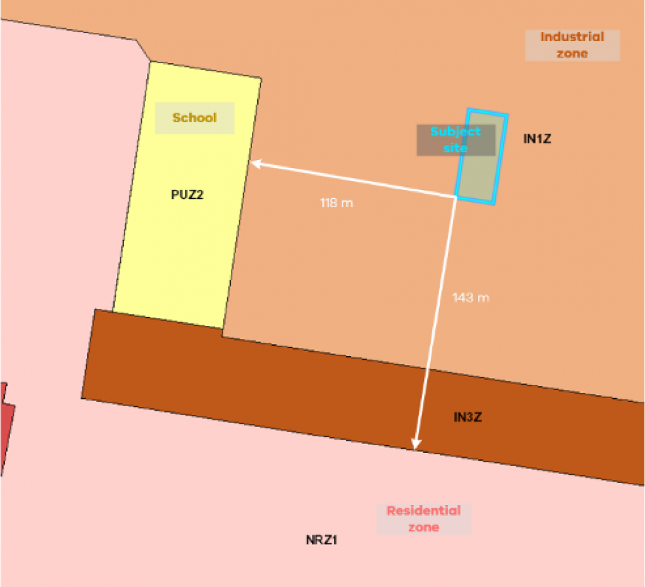
Bakery is included under the Industry land use term as a Section 1 use in the IN1Z, and no planning permit is required if certain conditions are met. These conditions include:
- The use must not be a purpose in the table to clause 53.10 with no threshold distance specified.
- The land must be at least the following distances from land (not a road) which is in an Activity Centre Zone, Capital City Zone, Commercial 1 Zone, Docklands Zone, Residential Zone or Rural Living Zone, land used for a hospital or education centre or land in a Public Acquisition Overlay to be acquired for a hospital or an education centre:
- The threshold distance, for a purpose listed in the table to clause 53.10.
- 30 metres, for a purpose not listed in the table to clause 53.10.
Bakery (other than one ancillary to a shop) is listed in the table to clause 53.10 and has threshold distances specified as follows:
- 100 metres – for a bakery producing more than 200 tonnes per year.
- 500 metres – for a bakery including night-time operations, producing more than 200 tonnes per year.
The bakery proposes to produce less than 200 tonnes per year. This means the threshold distances in clause 53.10 do not apply and instead the proposed bakery must be at least 30 metres from the nominated sensitive zones and land uses.
At its nearest point, the subject site is 118 metres from land used for an education centre (school) and 143 metres from land in a residential zone. Therefore, the proposal does not require a planning permit.
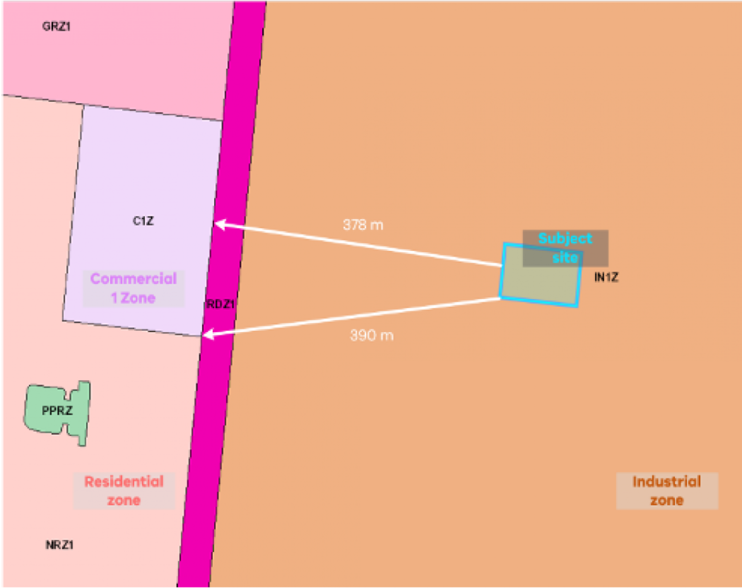
Scenario 2 – Transfer station
The subject site is in the Industrial 1 Zone (IN1Z).
Map below showing industrial site in IN1Z to the east, with a Commercial 1 Zone 378m to the west and a residential zone 390m to the west, south of the Commercial 1 Zone.
Transfer station is a Section 2 use in the IN1Z, so a planning permit is required.
In addition to requiring a planning permit for the use of the land, the land must be at least 30 metres from land (not a road) which is in a residential zone or land used for a hospital or an education centre or land in a Public Acquisition Overlay to be acquired for a hospital or an education centre – otherwise it is prohibited. At its nearest point, the subject site is 390 metres from land in a residential zone, so a planning permit can be considered.
In line with the referral provisions in clause 66.02-7, an application to use land for an industry, utility installation or warehouse for a purpose listed in the table to clause 53.10 with no threshold distance specified or if the threshold distance is not to be met must be referred to EPA.
Refuse and used material storage, sorting and recovery in a transfer station is listed in the table to clause 53.10 and has threshold distances specified as follows:
- 500 metres – for a transfer station accepting organic wastes.
- 200 metres – for other transfer stations.
The transfer station is to accept various types of organic waste, so the threshold distance of 500 metres applies. The threshold distances in clause 53.10 are measured from the property boundary of the proposed land use to:
- land (not a road) in an Activity Centre Zone, Capital City Zone, Commercial 1 Zone, Docklands Zone, residential zone or Rural Living Zone
- land used for a hospital, education centre, or corrective institution
- land in a Public Acquisition Overlay to be acquired for a hospital, education centre or corrective institution.
As there is land in a Commercial 1 Zone, 378 metres away from the subject site, the threshold distance cannot be met, and the permit application must be referred to EPA for consideration.
EPA considers a range of factors in assessing whether a proposal is acceptable, including the size of the proposal and the standard of industrial equipment and technology, the type of likely off-site impacts and whether the proposal meets the relevant separation distance in the EPA separation distance and landfill buffer guidelines. As a determining referral authority, if EPA objects to the proposal then the responsible authority must refuse the application, and if EPA specifies conditions, those conditions must be included in any permit granted.
If EPA does not object to the proposal, a permit may be granted subject to the decision of the responsible authority.
Managing buffers where there is existing or potential land use conflict
While ensuring land use compatibility is a key planning objective, this is difficult where incompatible land uses already encroach, or are likely to encroach, within the buffers of industries and other uses with potential off-site impacts. Options to manage land within buffer areas include pursuing land use transition and restricting use and development.
Land use transition
Land use conflict can be addressed through transitioning incompatible uses (either the emitting uses or sensitive uses) out of an area. This should consider the full range of planning tools available, including zoning. While rezoning (back zoning) land in established areas is not always feasible, this approach establishes a strong indication of desired land use and sets clear expectations for industry and the community.
Buffer Area Overlay
The Buffer Area Overlay (BAO) can be used in certain circumstances to prevent future encroachment and intensification of incompatible use and development within the buffer areas of industry, warehouse, infrastructure or other uses with potential off-site impacts.
The BAO supports implementation of the objective and strategies in clause 13.07-1S Land use compatibility. The BAO complements clause 53.10, which helps to ensure that industry establishes appropriately, by addressing the reverse situation so that land use and development around existing industry is appropriate.
Criteria must be met, and information must be provided to apply the BAO. Issues of land use conflict and compatibility may still exist in areas not covered by the BAO.
Applying the Buffer Area Overlay
The purpose of the BAO is to identify areas where there is potential for off-site impacts on safety or human health, or significant off-site impacts on amenity, from industry, warehouse, infrastructure or other uses. The BAO also ensures that use and development within buffer areas is compatible with potential off-site impacts. Application of the BAO can be led by industry operators or councils. See Appendix B for a summary of steps to apply the BAO.
Principles
When considering the application of the BAO, the following principles need to be understood:
- Policy and zoning are the primary and preferred tools within the planning system for ensuring land use compatibility.
- Overlays and associated planning scheme maps not only identify land, but also apply requirements that improve land use and development outcomes.
Eligibility
The BAO can be applied to land uses that are compliant with relevant regulations and standards but pose a risk of unintended off-site impacts on human health or safety, or significant off-site impacts on amenity.
Step One
Consider compliance and impacts
Operators should consider the compliance of their operations and the nature of potential off-site impacts.
The use must be compliant with existing regulations and standards relating to off-site impacts or land use compatibility, such as those of EPA Victoria and other regulatory authorities. This could include:
- Permissions, including licences, issued under the Environment Protection Act.
- Planning and building permits
- Environment protection policies
- Siting, design, operation and rehabilitation of landfills - Landfill BPEM (EPA, August 2015)
- Dangerous Goods Act 1985 and Occupational Health and Safety Regulations 2017
- Pipelines Act, regulations and Australian Standard AS 2885
- Work authorities and work plans under the Mineral Resources (Sustainable Development) Act 1990.
The BAO does not duplicate or replace existing laws, regulations and standards relating to off-site impacts or land use compatibility. The BAO identifies areas where, despite compliance with these laws, regulations and standards, unintended off-site impacts may still occur and those residual risks may be required to be managed through land use and development controls. Application of a BAO however does not replace the need for an operator to minimise risks to surrounding areas or comply with existing requirements.
EPA publications relevant to demonstration of compliance
Implementing the general environmental duty: A guide for licence holders
Publication 1856 – Reasonably practicable (September 2020)
Follow a risk management process
Publication 1695.1 – Assessing and controlling risk: A guide for business (August 2018)
The use must have potential for unintended off-site impacts on human health or safety, or significant off-site impacts on amenity.
The BAO is designed to address:
- human health, safety or significant amenity impacts
- off-site impacts
- unintended impacts.
Operators should use the risk exposure matrix for application of the BAO (see Appendix C) to consider the residual risk of potential unintended off-site impacts and then seek advice from EPA and/or other relevant authorities in Step 2 and Step 3.
The BAO is not intended to address lower level amenity impacts, i.e. those that are unlikely to have significant impacts over time. Although it is not the role of the BAO to manage these impacts, relevant environmental legislation and regulations still apply along with planning mechanisms, such as the Planning Policy Framework, zones and clause 53.10.
Noise, dust and odour, which are typically considered to be lower-level amenity impacts, can sometimes pose significant amenity or human health risks depending on a number of factors.
What are significant off-site impacts on amenity?
The BAO can apply where there is potential for significant unintended off-site impacts on amenity. For the purposes of applying the BAO, the significance of impacts on amenity, particularly noise, dust and odour, depends on the following factors:
- Frequency (how often the impact occurs)
- Duration (how long the impact lasts)
- Intensity (how obvious the impact is)
- Character (what the character or nature of the impact is)
- Context (what the experience of a person exposed to the impact would be).
The risk exposure matrix for application of the BAO at Appendix C bases the consequence criteria for amenity, human health and safety impacts on these factors.
Step Two
Discussion with council and relevant authorities
Operators should have an initial discussion with council and relevant authorities about the proposed application of the BAO.
In preparation for this discussion, and based on the considerations outlined in Step 1, operators must demonstrate:
- a documented history of compliance with all relevant laws, regulations and standards (and any applicable licences or approvals) relating to off-site impacts or land use compatibility, such as those administered by EPA Victoria and other relevant authorities
- that all reasonably practicable measures to minimise future off-site impacts have been considered and exhausted
- consideration of potential unintended off-site impacts.
Step Three
Advise on compliance and potential off-site impacts
The relevant authority, such as EPA, should provide advice about known historical impacts and understood potential risks based on information supplied by the operator.
What to expect from EPA
For many industries and impacts, EPA will be the relevant authority to provide advice. Based on initial discussions and information provided by the operator, EPA will consider:
- whether all reasonably practicable measures to minimise off-site impacts have been considered and exhausted
- whether the BAO appears appropriate based on compliance and residual risk.
Enquiries should be directed to: development.advisory@epa.vic.gov.au
For more information about EPA considerations in strategic planning, visit about Strategic planning / Environment Protection Authority.
Assessment
Application of the BAO to land uses must be based on evidence, demonstrating the types of potential off-site impacts, the spatial extent of those impacts (the buffer area) and appropriate requirements for land use and development within the buffer area.
Step Four
Prepare assessment
An assessment of the potential off-site impacts of the use must be undertaken to inform preparation of the BAO schedule and decision on the amendment.
The assessment must be undertaken by a qualified professional and demonstrate:
- the potential of the land use for off-site safety, human health or significant amenity impacts, such as blast, hazardous air pollutants, noise or odour
- the spatial extent of relevant potential impacts, (reflecting current or approved operations), i.e. the buffer area
- based on potential impacts, what future land uses need to be managed or prohibited in the buffer area. This could include incompatible industrial uses.
- based on potential impacts, what future buildings and works need to be managed or prohibited in the buffer area
- based on potential impacts, how future subdivision needs to be managed or prohibited in the buffer area.
The assessment should also advise:
- what information needs to be provided with permit applications to inform decision making, i.e. application requirements
- whether the views of any agencies are required to inform decision making.
Operators should provide this assessment to the relevant authority, such as EPA, for advice.
Step Five
Advise on recommendations in assessment
The relevant authority, such as EPA, should provide advice on findings and recommendations in the assessment.
The spatial extent of the buffer area determined through the site-specific assessment should consider variables such as prevailing weather conditions, topography etc. Default distances such as those found in EPA guidance material or clause 53.10 are not appropriate for this assessment.
Information about what land uses, buildings and works and subdivision need to be managed or prohibited within the buffer area will inform requirements in the BAO schedule.
If certain land uses, buildings and works or subdivision require a permit due to potential off-site impacts within the buffer area, information or assessments may need to be provided by permit applicants to support responsible authorities in making a decision.
Implementation
The BAO is implemented through schedules to the overlay. These are informed by the evidence base. To support appropriate application of the overlay, certain information must be submitted with proposals to apply the BAO.
Step Six
Discuss implementation
Operators and councils should discuss the recommendations in the site-specific assessment and how they can be implemented through a schedule(s) to the BAO.
Step Seven
Draft schedule(s) informed by evidence base
Councils should draft a BAO schedule or schedules based on the recommendations in the assessment. The BAO schedule is comprised of the following, as appropriate, informed by the completed assessment:
- A detailed statement of risk for the buffer area that identifies the potential off-site safety, human health or significant amenity impacts of the land use
- Up to five objectives to be achieved for the buffer area – this could include what compatible land uses are to be encouraged within the buffer area
- Requirements for use of land, subdivision and buildings and works
- Reference to referral requirements (referral requirements themselves should be included in the schedule to clause 66.04)
- Application requirements
- Exemption from notice and review
- Decision guidelines.
The assessment document itself can be included as a background document in the schedule to clause 72.08.
Known requirements for use and development should be built into the schedule to the overlay where possible, rather than left for referral.
For example, rather than referring applications for use of land proposals that will always receive a 'no' response from referral authorities – prohibit them through the schedule to the overlay.
Step Eight
Submit application for authorisation with required information
Councils should submit an application for authorisation to prepare an amendment to the Minister for Planning. This must include the following information required by the Minister under s.8A of the Planning and Environment Act 1987:
- Information or reports demonstrating that the land use is compliant with regulations and standards relating to off-site impacts or land use compatibility and that all reasonably practicable measures to minimise off-site impacts have been considered and exhausted
- An assessment demonstrating the potential of the land use for off-site safety, human health or significant amenity impacts, the spatial extent of potential impacts and appropriate restrictions on land use and development in the buffer area
- The written views of the Environment Protection Authority or other relevant authority in relation to the above information and the proposed application of the BAO.
This information will provide evidence to support appropriate application of the Buffer Area Overlay.
Step Nine
Planning scheme amendment process
Implementation of the BAO schedule(s) via the standard planning scheme amendment process.
Review
It is important that BAO schedule(s) are reviewed regularly to ensure they continue to reflect the risk profile of the land use. Review of schedule(s) could involve changes to mapping, ordinance or both.
Step Ten
Periodically review application of the BAO
Operators should inform councils about anything that may trigger the need to review application of the BAO, such as closure or significant changes in operations.
Councils should review BAO schedules as part of regular planning scheme reviews and when otherwise required.
If a BAO schedule needs to be modified, Step 4 to Step 9 above should be followed to inform changes.
Operators and councils should discuss resources required to undertake any further assessments.
Other considerations
The BAO can be used to manage impacts from more than one site in an area or precinct. The same criteria applies as with individual sites. An assessment that considers each site is still required to demonstrate potential off-site impacts and appropriate land use and development responses within the buffer area(s). Cumulative impacts should also be considered as part of this assessment, where relevant.
Multiple schedules can be used to cover different impacts from a single site (see example below). Each schedule needs its own statement of risk that reflects the potential impacts in that buffer area.
Image below showing two overlapping areas, both containing a landfill site. One overlapping area is a landfill gas buffer area with restrictions on sensitive uses and landfill gas mitigation measures – schedule 1. The other overlapping area is the odour buffer area with restrictions on sensitive uses – schedule 2.

Appendix D contains example BAO schedules for a landfill scenario where both landfill gas impacts and odour impacts need to be addressed.
The BAO could potentially be applied to licensed pipelines in certain circumstances. Energy Safe Victoria is working on a standardised approach for the application of planning controls. Future proposals to apply planning controls to pipelines will be informed by this work.
The BAO is a purpose-built tool to manage buffers through the planning system and replaces the use of ESOs for buffer purposes. Existing ESOs that have been used to manage buffers can remain in place, although in some cases replacement with a BAO may be desired.
Page last updated: 19/02/25