Learn about the policy, regulations and what is involved in strategic planning for bushfire
On this page:
What is the regulatory framework?
The planning and building systems regulate land use and development to ensure bushfire hazard and risk are considered and managed.
The planning policy framework and other planning scheme provisions provide the basis for how planning schemes and planning decisions assess and respond to bushfire.
The building system ensures that bushfire protection is considered as part of the building permit.
Read more about the planning provisions and the building regulations below.
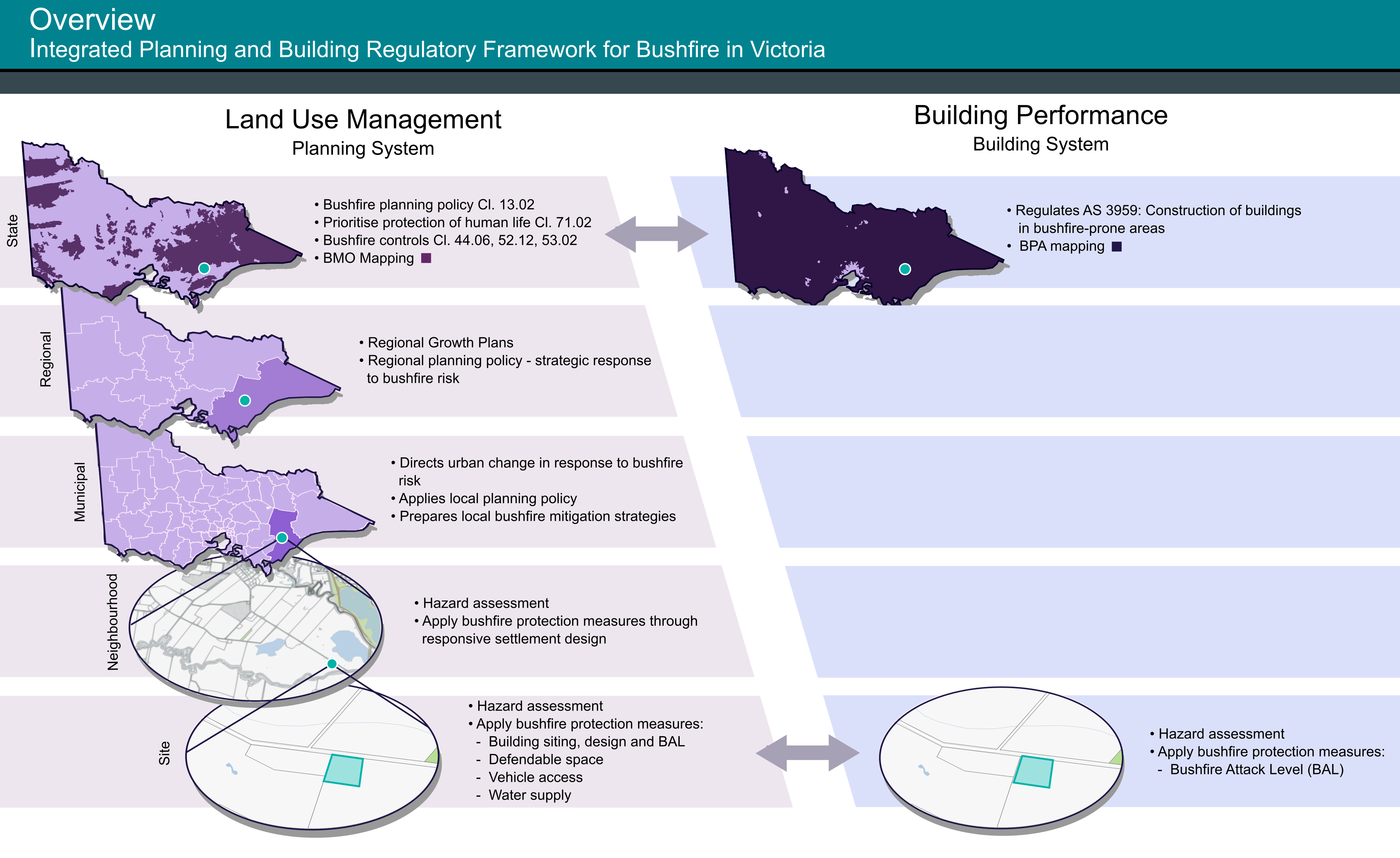
How the planning and building system works
The planning and building system requirements typically influence new land use and development.
The systems work together in an integrated way at the state and site levels. This avoids regulatory duplication and ensures effective development outcomes.
Key elements of the integrated system are illustrated in the diagrams below.
View diagrams on the integrated planning and building regulatory framework for bushfire in Victoria:
The planning policy framework includes policies that provide the context for decision making by planning and responsible authorities in relation bushfire.
Clause 13.01-1S natural hazard and climate change
Clause 13.01-1S seeks to minimise the impacts of natural hazards and adapt to the impacts of climate change through risk-based planning. It ensures, that hazard assessments, risk assessments, strategic planning and planning applications have regard to all natural hazards and their risks.
Clause 13.02-1S bushfire planning
Clause 13.02-1S, the state bushfire policy provides specific strategies that guide and direct decision making. They have been developed over many years in response to the increasing risk of bushfires in Victoria.
The objective of the policy is to strengthen the resilience of settlements and communities to bushfire through risk-based planning that prioritises the protection of human life.
proposed to be used or developed in a way that may create a bushfire hazard.
Clause 71.02-3 integrated decision making
Clause 71.02 sets out the operation of the planning policy framework. It requires that planning and responsible authorities in their decision making must prioritise the protection of human life over all other policy objectives or issues in bushfire affected areas.
The protection of human life cannot be balanced or traded off against other objectives or issues.
This clause applies to:
strategic planning proposals
planning policy development
planning scheme amendments
planning permit applications.
Clause 13.02-1S
Clause 13.02-1S, the state bushfire policy, has a specific objective that guides and directs planning decision making.
The state bushfire policy objective is to strengthen the resilience of settlements and communities to bushfire through risk based planning that prioritises the protection of human life.
It reflects the:
Victorian government’s commitment to creating a safer state
important role of planning decision making which can avoid and reduce the risk of bushfire to people and communities.
It ensures:
a rigorous assessment of bushfire before decisions are made
growth is directed to low risk areas
that development considers and includes bushfire protection measures in all stages of the planning process.
Bushfire strategies in the planning policy framework
Clause 13.02-1S has specific strategies that guide and direct planning decision making to prioritise the protection of human life (the objective of state bushfire policy).
There are four key strategies:
Ensuring bushfire is considered whenever there is a bushfire hazard.
The state bushfire policy requires the best available science be applied to identify vegetation, topographic and climatic conditions that create a bushfire hazard.
A bushfire hazard is created by:
fuel, such as leaf litter and vegetation, and may include forested areas, woodlands, shrublands, heathlands or grasslands
the potential for topography and weather conditions to contribute to fire behaviour.
The hazard can influence what a bushfire or grassfire will do and how it will behave as it is driven by the environment and weather across the landscape.
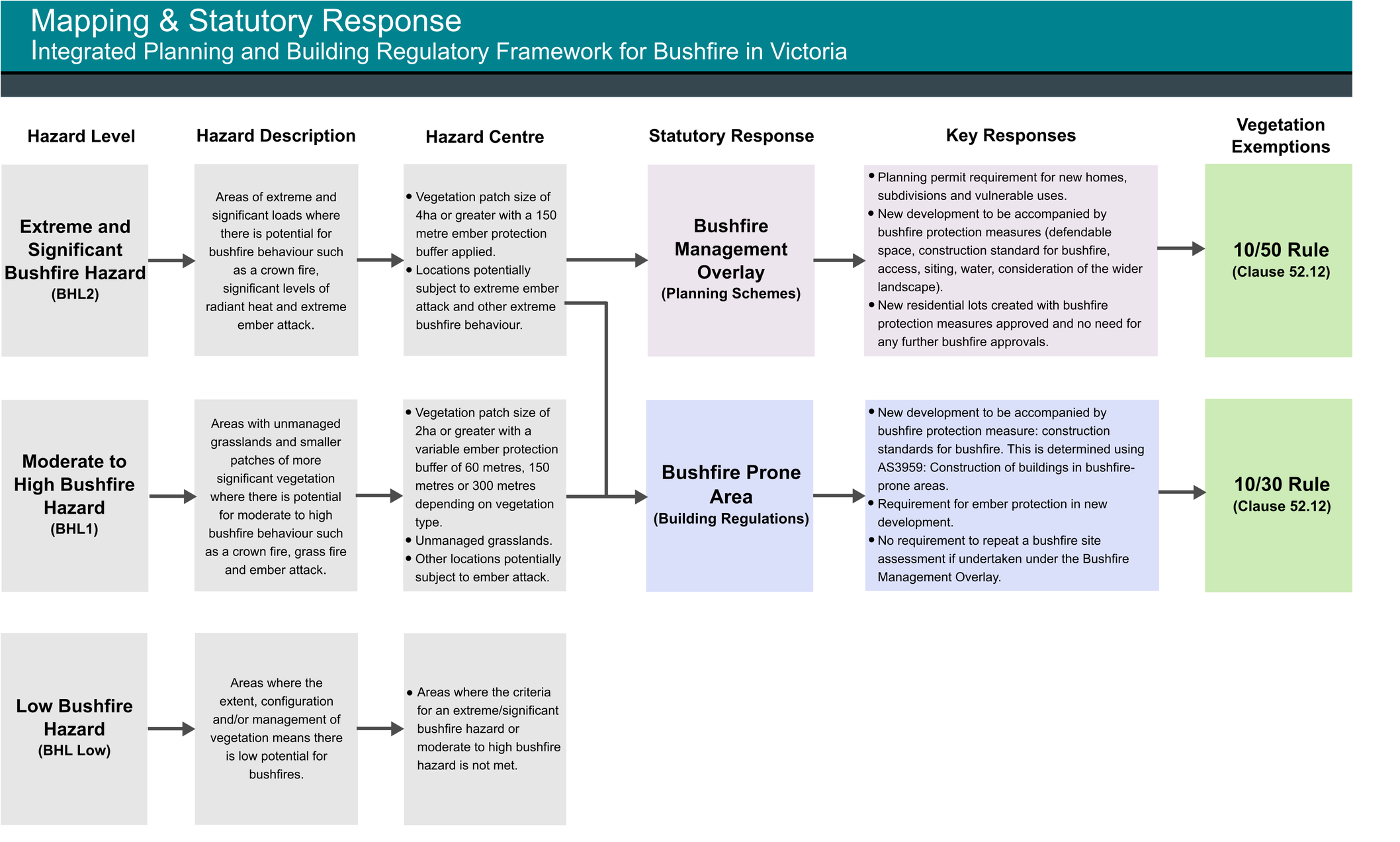
The Victorian Government, working in partnership with local councils and fire authorities, has used bushfire hazard information to designate bushfire prone areas under the Building Act 1993 and the Bushfire Management Overlay (BMO) in planning schemes. These designated areas ensure the bushfire hazard triggers planning and building permit requirements and that bushfire is considered in decision making.
The bushfire hazard is considered in hazard assessments prepared at the time planning and building decisions are made. This ensures that bushfire is considered from the outset to determine if a proposal should proceed and, if it does, what bushfire protection measures should be included.
These hazard assessments include:
Bushfire hazard landscape assessment. This considers how the extent of the bushfire hazard may affect a location and the things that provide bushfire protection (for example, fuels, the road network, and places of shelter). It is required to be prepared in certain circumstance, such as when making decisions on strategic planning projects, planning scheme amendments and planning applications (some exemptions apply).
Bushfire hazard site assessment. This considers the classified vegetation and slope in the area surrounding the site. It helps determine the setback and area to be managed as defendable space. It can also be used to assist in determining the appropriate construction standard for development or whether radiant heat exposure benchmarks have been met in larger scale developments. It is required when making decisions on strategic planning projects, planning scheme amendments and most decisions on planning applications.
Directing the location of new use, development and subdivision based on bushfire considerations.
The state bushfire policy strategies ensure new uses, developments and subdivisions are directed, wherever possible, to low risk locations and areas that can protect human life before, during and after a bushfire.
Low risk locations are areas that:
The risk from large bushfires in the wider landscape can be managed including the risk associated with higher levels of ember attack.
On completion, development will not be exposed to higher levels of radiant heat, which is no more than 12.5 kilowatts/square metre for locations subject to strategic planning or the preparation of a planning scheme amendment.
There is reliable access to areas of land where human life can be better protected from the effects of bushfire. This would include protection from flame contact and radiant heat.
Bushfire protection measures can be provided to manage the on-going risk from bushfire. This would include demonstrating that by applying bushfire protection measures that bushfire can be managed. Deciding on a low risk location will mean a thorough assessment of all potential alternative locations for development. This needs to happen at the landscape and settlement scale. For example, when undertaking strategic planning and large scale development proposals.
This will ensure that new use, development and subdivision are sited in appropriate locations. A bushfire hazard landscape assessment and bushfire hazard site assessment inform these decisions.
Planning proposals must assess and apply bushfire protection measures.
All planning proposals including strategic planning documents, planning scheme amendment and planning permit applications must identify and include bushfire protection measures in the design response wherever there is a bushfire hazard. They must also demonstrate that they can be adequately implemented.
Bushfire protection measures ensure that development can better withstand the effects of a bushfire event and help ensure risk to existing and future residents, property and community infrastructure is not increased. Importantly they themselves make a development suitable.
A range of bushfire protection measure requirements are set out in different parts of the planning scheme. Their suitability and application will be dependent on the nature of the proposal. They can be passive (for example, the layout of buildings), or active (vegetation management).
Applying bushfire protection measures should never be delayed to later decisions or approvals. This is particularly relevant for strategic planning proposals and planning scheme amendments. Bushfire must be considered and included at the earliest stages of design and approved as part of the decision process.
The need for bushfire protection measures arise from the outcomes of bushfire hazard assessments. Bushfire protection measures should give the decision maker confidence that bushfire can be managed in the ongoing use of the land and that the planning approval is appropriate.
The suitability of a location for development should always be considered first. Bushfire protection measures should only be applied to build resilience and to better manage the residual (or remaining) bushfire risk once it is decided the location is suitable.
Achieve no increase in risk to human life and reduce risks where possible through effective decision making.
Planning decisions aim not to increase the bushfire risk to existing and future residents, property and community infrastructure.
This is achieved over time through many planning decisions that consider and apply the state bushfire strategies and other bushfire planning provisions. These decisions strengthen the resilience of settlements and communities to bushfire and prioritise the protection of human life.
The state bushfire policy is explicit that proposals must only be approved where a landowner or proponent has properly considered and assessed bushfire hazards and demonstrated that risk to life can be mitigated and reduced through bushfire protection measures.
Effective decision making will often be supported by the advice of bushfire and emergency management experts.
The state bushfire policy requires decision makers to consult early with emergency management agencies and the relevant fire authority to receive their recommendations on appropriate bushfire responses.
This is particularly important for strategic and policy proposals, and planning scheme amendments. This includes Victoria’s fire authorities (Country Fire Authority, Fire Rescue Victoria and the Department of Energy, Environment and Climate Action), and local councils through their municipal fire prevention functions.
You can find more information in the Victoria Planning Provisions below:
Strategic planning for bushfire involves a process of identifying, assessing and responding to the bushfire hazard and risk when planning for future land use, development and settlement growth.
It helps build more resilient and safer communities. The overarching aim is to prioritise the protection of human life.
Why is strategic planning for bushfire important?
Strategic planning for bushfire is important as it can establish clear expectations around where to direct future land use and development and what planning policy responses are appropriate to address and minimise bushfire risks.
This big picture approach can achieve significant mitigation, fire prevention and environmental benefits upfront including:
avoiding bushfire risk in the first instance. If a proposal is in a high-risk location, bushfire protection measures may not be enough to mitigate or reduce the risk
addressing bushfire risk at the settlement rather than site scale
deciding appropriate areas for urban growth, including considering alternate locations for development
identifying when planned bushfire protection measures may be incompatible with other environmental objectives
designing settlements that minimise risk to people and build better resilience within the community.
Landscape scale factors drive bushfire behaviour. The bushfire hazard landscape assessment (landscape assessment) does not predict the outcome of a bushfire event. It provides information that builds a better understanding of the bushfire risk at a given location and helps inform decision makers.
A landscape assessment directs where new development or settlement growth should occur and helps determine the suitability of a location for development.
It can also show the positive attributes of the site and its surrounds, and support proposals in areas suitable for development.
The bushfire hazard in the surrounding landscape must be assessed when preparing any strategic document.
This involves:
identifying bushfire hazards in the broader landscape, up to 20-75km from a given location
considering the surrounding physical environment and how this could influence fire behaviour i.e. slope and topography
identifying bushfire scenarios that may impact the site, for example the direction a bushfire could approach, and the distance of a bushfire run to the location
assessing the likely influence of weather conditions, such as wind, during a bushfire event
identifying the availability of evacuation routes and safer areas
considering existing or proposed fire prevention and emergency management activities
deciding if the risk can be mitigated and incorporating appropriate bushfire protection measures in the design and/or policy response
the bushfire history in the area.
Refer to the Bushfire Hazard Assessments Guideline for further information:
This includes information on how to prepare a landscape assessment, assess the bushfire risk in the landscape, and how to use this information to assess the viability of planning proposals. Large scale or complex strategic planning proposal and growth planning proposals will require more details and a greater level of analysis than what is described in this guideline. Advice on undertaking a landscape assessment for these types of proposal should be obtained from the relevant fire authority. The guideline may however assist with understanding the principles of landscape assessments before consulting with the fire authority.
Resources
The following resources are available to assist planning authorities.
