
Status
On this page:
Protecting operational airspace is important to ensure aircraft safety and airport efficiency.
The National Airports Safeguarding Framework addresses protected airspace through Guideline F : Managing the Risk of Intrusions into the Protected Operational Airspace of Airports.
About protected airspace
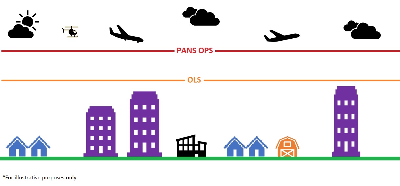
There are two sets of ‘invisible’ above-ground surfaces around an airport to safeguard its operation. The airspace above each of these surfaces forms an airport’s protected airspace, protecting aircraft from obstacles and activities that are a threat to aircraft safety. Any intrusion into the protected airspace affects airport operations.
The two surfaces are:
Obstacle Limitation Surface (OLS)
The OLS is generally the lower of the two surfaces. It is designed to provide protection for aircraft when pilots are flying by sight, known as Visual Flight Rules (VFR).
Procedures for Air Navigation Services – Operations (PANS-OPS)
The PANS-OPS is generally higher than the OLS. It provides protection for aircraft flying by instruments – for example in conditions with poor visibility, known as Instrument Flight Rules (IFR).
OLS and PANS-OPS charts are prepared by the airport operator and are required to be made available to the public. These charts should be considered when assessing development applications around airports. To facilitate this, appropriate provisions should be incorporated into planning schemes to control intrusions into protected airspace.
Further information and guidance on protected airspace is contained within the National Airports Safeguarding Framework - Guideline F: Managing the Risk of Intrusions into the Protected Airspace of Airports.
If OLS and/or PANS-OPS data for specific airports exists, it can be found in their current approved master plan.
Safeguards
The Department of Transport and Planning uses a 3D model when assessing planning proposals in the central city and key urban renewal sites. This model includes the protected airspace for Melbourne, Essendon and Moorabbin airports.
The model helps to inform the state's strategic planning and enables early consideration of a proposal’s possible impact on such airspace.
The Design and Development Overlay (DDO) can be applied in planning schemes to regulate the height of development in locations where buildings and other structures could intrude into protected airspace. The DDO is also used in some planning schemes to control the height of development around helicopter landing sites, including hospitals (see Planning Practice Note 75: Planning Requirements for Heliports and Helicopter Landing Sites).
The airport operator and the Commonwealth, through its regulators the Civil Aviation Safety Authority (CASA) and Airservices Australia are responsible for managing protected airspace and assessing any potential airspace infringement. Airport operators and agencies assess and provide advice on the maximum allowable development height and should be consulted early in the development proposal consideration process.
More information
National Airports Safeguarding Framework Guideline F addresses the importance of the early identification of potential impacts on protected airspace and the process for a proponent to notify the relevant airport operator in the first instance.
The Minister for Planning has introduced permanent planning controls to inform the future development of the Central City area, including building heights, through Amendment C270 to the Melbourne Planning Scheme.
Amendment GC41 applied the Design and Development Overlay to the flight paths of helipads at six Victorian public hospitals to protect operational airspace of helicopters.
The Commonwealth Department of Infrastructure, Regional Development and Cities has published information about the protected airspace of Commonwealth leased airports:
Also see:
- CASA Advisory Circular AC 139-5(1) – Plume Rise Assessments (PDF)
- Airports (Protection of Airspace) Regulations 1996
- Modernising Airspace Protection - Public Consultation Paper, Department of Infrastructure and Regional Development (comments closed 28 February 2017)
- AC 139-08 v2.0 - Reporting of tall structures and hazardous plume source (PDF)
Page last updated: 07/11/25