Learn about the measures taken to minimise the impact of aircraft noise on communities surrounding airports
Status
Guide
current
Published:
Last updated:
On this page:
Managing the use and development of land surrounding airports protects flight paths from inappropriate development and limits the subsequent exposure of people to aircraft noise.
This is important to the ongoing viability of airports, particularly those with curfew free operations, but also to minimise impacts on surrounding communities.
The ANEF system is a measure of aircraft noise exposure levels around airports and aerodromes. ANEF contours can be displayed in 15, 20, 25, 30, 35 and 40 ANEF units. The larger contour number represents areas that may be subject to higher aircraft noise. ANEF contours are based on the average daily noise exposure levels over a one-year period and take into account a range of factors, including noise intensity, duration and aircraft movements.
ANEF contours align with the flight paths in use when an airport is operating at its future capacity. There are three ANEF categories for airport master plans:
standard
long range
ultimate practical capacity
For the purpose of land use planning, the preference is to use the long range or ultimate practical capacity. Victoria’s planning system supports use of the ultimate practical capacity ANEF for Commonwealth-leased airports.
Airservices Australia endorses each airport's ANEF for technical accuracy. ANEF contours are included within approved airport master plans, and is the agreed statutory noise metric applied in Australia.
Number above (N) contours
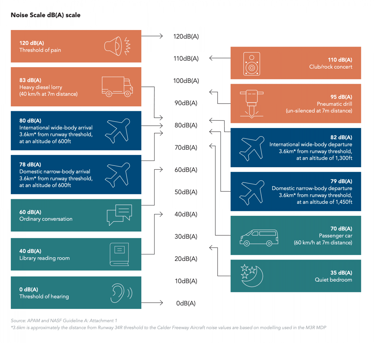
Number above contours, also known as N contours, are decibel measurements that indicate daily potential noise exposure for an area. This is the number of aircraft noise events exceeding 60dB(A), 65dB(A) or 70dB(A) per day, as opposed to the annual average approach that informs the application of ANEF contours. For example, an area covered by the N60 contour in the Melbourne Airport Master Plan 2022 shows that that there will be 100 or more aircraft noise events over 60db(A) per day.
The areas where these controls apply are determined by an airport's ANEF. The MAEO reflects Melbourne Airport’s planned four-runway layout and is based on the ANEF contours in the Melbourne Airport Master Plan 2018. The MAEO may be updated in the future to reflect the ANEF contours in updated Melbourne Airport Master Plans.
Victoria, in agreeing to include the National Airports Safeguarding Framework in the planning system, implements N contours as an alternative noise metric for consideration in strategic planning decisions only, where there is potential for future communities to be unnecessarily exposed to aircraft noise (refer to Clause 18.02-7S).
Where N contours exist, zoning or overlay changes that allow noise-sensitive uses outside the Urban Growth Boundary should be avoided, while measures to reduce the impact of aircraft noise in planning for areas within the Urban Growth Boundary is encouraged. N contours should be examined when considering strategic planning proposals near airports. This is in addition to the ANEF contours, which remain the metric applied in Victoria for statutory planning purposes through the above-mentioned AEO and MAEO.
Melbourne Airport Environs Overlay Advisory Note
The New Planning Provisions for Melbourne Airport Advisory Note, 2007 provides information on the MAEO controls and the key features of the controls.
To ensure Melbourne Airport's ongoing protection, the government has committed to review the declared Melbourne Airport Environs Area and associated Melbourne Airport Environs Strategy Plan, which was approved by Parliament in 2003. This will inform departmental advice.
VicPlan, the state-wide map viewer for zone and overlay information, can be used to search for a property and generate a report showing the property's proximity to planning scheme overlays, such as the AEO and the MAEO. Separate to the planning scheme overlays, and where available, the latest approved noise contours from airport master plans are also included in VicPlan.
The ‘Airports’ layer in VicPlan shows current approved airport master plan data for information purposes and to assist strategic planning consideration under Clause 18.02-7 of all planning schemes.