
On this page:
This is one of two practice notes on planning for flooding using the original flood provisions. The other is Planning Practice Note 11a: Planning Permit Applications under the Original Flood Provisions (Department of Transport and Planning (DTP), October 2026), which explains how to apply for and assess a planning permit on land prone to flooding.
The original flood provisions are the Urban Floodway Zone (UFZ), Floodway Overlay (FO), Land Subject to Inundation Overlay (LSIO) and Special Building Overlay (SBO). These are distinct from new flood planning provisions prepared in response to Victoria’s statewide flood reforms announced by Government in October 2025.
The new provisions are the Flood Management Zone and Flood Management Overlay and will be progressively implemented through new or updated flood studies.
Planning scheme amendments currently underway to implement original flood studies can continue to apply the original provisions.
Flooding is a natural hazard but, unlike most other natural hazards, floods are to a great degree predictable in terms of their location, depth and extent. This means that appropriate measures can be developed to reduce flood damage. Land use planning has a key role in flood prevention. Through careful planning, flood risks to life, property and community infrastructure can be minimised and the environmental significance of our floodplains protected.
Section 6(2)(e) of the Planning and Environment Act 1987 enables planning schemes to ‘regulate or prohibit any use or development in hazardous areas, or areas likely to become hazardous’. Planning schemes contain State planning policy for flood planning requiring, among other things, that flood risk be considered in the preparation of planning schemes and in land use and development decisions.
The statutory authorities responsible for the collection of flood information and for land use planning in areas prone to flooding are councils and floodplain management authorities (Catchment Management Authorities (CMAs) and Melbourne Water). The specific roles and responsibilities of each organisation are outlined in Appendix A, Table 1.
Abbreviations
AEP: Annual Exceedance Probability
CMA: Catchment Management Authority
DEECA: Department of Energy, Environment and Climate Action
FMA: Floodplain Management Authority
FO: Floodway Overlay
LSIO: Land Subject to Inundation Overlay
PMF: Probable Maximum Flood
SBO: Special Building Overlay
UFZ: Urban Floodway Zone
A council can use flood information to articulate strategic directions for flooding in its Municipal Planning Strategy, local planning policy in clause 13.03-1L and apply the most appropriate flood provision to control land use and development in areas prone to flooding.
The planning authority has a range of tools to choose from to identify land prone to flooding in its planning scheme. There are four types of flood provisions available; the Urban Floodway Zone (UFZ), Floodway Overlay (FO), Land Subject to Inundation Overlay (LSIO) and Special Building Overlay (SBO). These have been derived based on the type of flooding and the potential level of risk to life and property.
The flood provisions do not address the cause of flooding, but the way future land use and development will impact on the flooding problem or be impacted themselves by flooding. The cause needs to be dealt with by separate means. This may include other actions of council and/or the floodplain management authority (FMA), such as flood mitigation measures, that may be linked to a corporate plan or a floodplain management strategy.
For more information on floodplain management, see the references at the end of this practice note. A glossary of commonly used terms in floodplain management (some used in this practice note) is also included.
Identifying land prone to flooding
Before flood provisions can be introduced to a planning scheme, information on the type and extent of flooding is required to accurately map land prone to flooding and apply the most appropriate flood provision.
Types of flooding
Floods in Victoria are usually caused by heavy or prolonged rainfall, which can result in either ‘mainstream flooding’ or ‘stormwater flooding’. These two types of flooding are the basis of the original flood zone and overlays in planning schemes.
Other types of flooding such as flooding associated with the failure of dams or water-supply systems are not specifically addressed in planning schemes.
Mainstream flooding
Heavy rainfall produces surface run-off which flows into streams and rivers. When there is a large amount of run-off, water overflows the river banks on to adjacent low-lying land causing flooding. This is called mainstream flooding and can occur in both rural and urban areas. The UFZ, FO and LSIO identify areas affected by mainstream flooding in planning schemes.
Stormwater flooding
During severe storms in urban areas, land can be affected by overland flows. These occur when the rainfall run-off exceeds the capacity of the piped drainage system and no provision has been made for overland flows. This is called stormwater flooding and often occurs in areas where there is a high density of existing development and a high flood damage potential. The SBO identifies areas affected by stormwater flooding in planning schemes.
Defining the extent of flooding
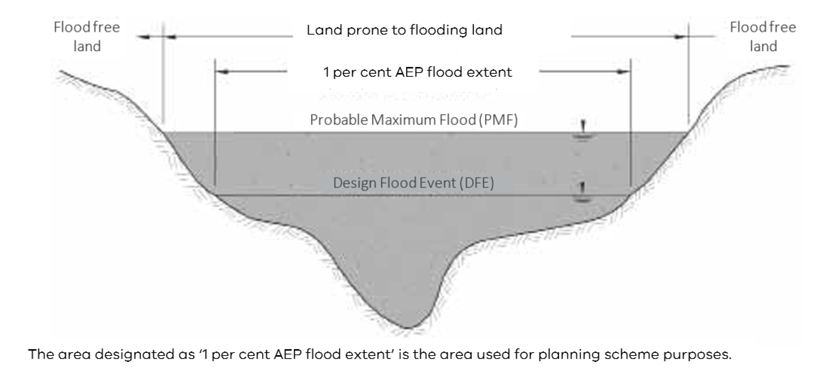
The ‘probable maximum flood’ (PMF) determines the maximum possible extent and height of flooding. This is the largest flood that could conceivably occur at a particular location. The area defined by the PMF is referred to as ‘flood prone’ and the area outside the PMF is referred to as ‘flood-free’ (see Figure 1).
In general, it is not practical or economical to provide land use planning or flood protection up to the PMF. A lesser flood standard, known as the ‘design flood event’, is adopted for land use planning purposes and is the area applicable for planning schemes. The area defined by the design flood event will be referred to as ‘land proneto flooding’ and can be divided into its relevant UFZ, FO, LSIO and SBO components as the case requires.
In Victoria, the design flood event for land use planning and building purposes is the 1 per cent Annual Exceedance Probability (AEP) (1 in 100-year) flood, which occurs on average once every 100 years. This is the basis for declaring flood levels and flood areas under the Water Act 1989 and for setting minimum building floor levels under the Building Act 1993.
Figure 1 - Defining land prone to flooding
Floodways
Floodways are areas that are important for the discharge or storage of water during major floods. They are usually aligned with naturally defined channels and depressions and often carry relatively deep and high velocity flows. Filling or even partial blockage of floodways can redistribute flood flows causing increased flood levels and flow velocities and increased flood risk for nearby properties. A blockage of a floodway can also have adverse environmental impacts, such as isolating wetlands, destroying natural habitats, eroding stream channels and increasing siltation.
The identification of floodway areas requires an assessment of the level of flood risk. One or more flood risk factors may apply to a given area and not all factors are given the same weight. The higher the potential flood risk, the more likely that the area will be defined as a floodway. For information on delineating floodways, contact your CMA (for Regional Victoria) or Melbourne Water (for the Greater Melbourne Area) for guidance.
Flood risk factors include:
- land use
- duration of flooding
- available flood warning time
- size and frequency of flood
- rate of rise of floodwater
- access and evacuation
- depth and velocity of floodwater
- available flood storage capacity
- environmental values.
Flood information
Where possible, the design flood event that defines the extent of land proneto flooding should be based on the 1 per cent AEP (1 in 100 year) flood. Keep in mind that this is not the maximum extent of flooding. The PMF defines the maximum flood extent. If the magnitude of the 1 per cent AEP (1 in 100 year) flood has not been determined, the design flood event should be based on the known extent of the largest recorded historic flood or on other available information.
The FMA or council usually collects flood information for use in planning schemes. This information should be included in a flood information report prepared by the relevant FMA and held for reference by the authority and the council. The report should link the flood boundaries shown in the planning scheme to a set of statements that explain the source of their delineation and include any necessary qualifications. Some example statements are listed below:
- The flood areas shown represent the best estimate of flood extent based on currently available information.
- Delineation of the LSIO is based on aerial photography of the October 1993 flood, which is currently the best estimate of the 1 per cent AEP (1 in 100 year).
- The flood areas shown do not necessarily represent the maximum possible extent of flooding and can be exceeded by a larger flood event.
- Other areas in the municipality may be liable to flooding but are not shown on the planning scheme maps due to lack of information at the present time.
- The flood areas are subject to change and new flood areas may be introduced as additional information becomes available and further investigations are carried out.
Sources of flood information
Flood information is available from various sources, including detailed flood studies, flood mapping projects, aerial photographs, historic flood levels, ground levels, soil and geology maps, river surveys, and local knowledge.
In many parts of Victoria, investigations have been undertaken to assess flood risk and identify land proneto flooding and its various components, including floodways and overland flow paths. At present, flood maps are not available for all areas of the state. Councils and FMAs should continually extend and update their current flood mapping database, giving priority to the higher flood-risk areas. Where adequate flood maps have not been prepared for a particular area, all available local knowledge should be documented and a flood mapping investigation should be initiated.
If detailed information on flooding is not available, in the interim the FMA should identify land known to be subject to flooding as best it can and the LSIO should be applied, even if the LSIO boundary is based on limited information. The boundary should be adjusted, and flood provisions included if necessary, after detailed flood mapping has been completed.
DEECA has undertaken a comprehensive flood mapping program for regional Victoria, which involves the presentation of available information on flood maps for use by CMAs and councils. These maps apply only to mainstream flooding and show the extent of flooding, floodways and flood levels. Melbourne Water has carried out detailed studies to identify overland flow paths of stormwater in urban areas of Melbourne, as well as mainstream flooding in some urban and rural areas.
What are the relevant flood provisions?
The flood provisions include:
- State Planning policy (clause 13.03 – Flood)
- Any Municipal Planning Strategy and Local Planning Policy
- Urban Floodway Zone (clause 37.03)
- Floodway Overlay (clause 44.03)
- Land Subject to Inundation Overlay (clause 44.04)
- Special Building Overlay (clause 44.05)
State planning policy
The state planning policy for flood (clause 13.02) of the Planning Policy Framework (PPF) includes an objective to strengthen the resilience of settlements and communities to flood (riverine, coastal and overland flows from stormwater) through risk-based planning that prioritises the protection of human life. The objective assists in the protection of:
- Property and community infrastructure from flood hazard.
- The natural flood-carrying capacity of rivers, streams and floodways.
- The flood storage function of floodplains and waterways.
- Floodplain areas of environmental significance.
- Floodplain areas of importance to river, wetland or marine and coastal ecosystems and habitats.
Strategies to achieve these objectives include:
- Prioritising the protection of human life over all other policy considerations in areas of high, very high and extreme flood risks.
- Identifying land affected by flooding, including land inundated by the 1 per cent AEP (1 in 100 year) flood extent or as determined by the FMA in planning schemes.
- Avoiding intensifying the impact of flooding through inappropriately located use and development.
Planning authorities must consider, as relevant:
- Regional floodplain strategies linked to the Victoria Floodplain Management Strategy and special area plans prepared under the Catchment and Land Protection Act 1994.
- Any floodplain management manuals or guidelines and catchment management, river health, wetland or floodplain management strategy adopted by the relevant responsible FMA.
- Any best practice environmental management guidelines for stormwater adopted by the Environment Protection Authority.
- Any local coastal hazard assessment or adaptation plan.
Municipal Planning Strategy and Local Planning Policy
Municipal Planning Strategy
If flooding is a planning issue in a municipality, this should be identified in the Municipal Planning Strategy. The Municipal Planning Strategy should give strategic direction for flood management and may also describe the characteristics of flooding including, the location of affected areas, flooding impacts and specific issues to help explain the basis of the strategic directions.
An example of a Municipal Planning Strategy extract on the issue of flooding is provided in Appendix B.
Local Planning Policies
Councils may also use a Local Planning Policy for flooding in clause 13.03-1L to guide decision-making on applications for planning permits on land prone to flooding.
Flood zone and overlays
The UFZ and overlays are specifically designed to identify land with particular flood characteristics.
Which flood zone or overlay should apply?
The nature of the flood risk and the type of flood information available will determine how and to what extent the flood provisions are applied in the planning scheme.
The UFZ and overlay provisions ensure that the use and development of land subject to flooding is made compatible with the level of flood risk through the planning permit process.
The UFZ applies to urban areas where the potential flood risk is high and strict controls over land use are required. The three overlays (FO, LSIO and SBO) cover a range of situations in both urban and rural areas where the potential flood risk is less than in the UFZ, and where control over development (buildings, works and subdivision) and not land use, is sufficient.
One or more of these tools can be applied to cover a particular flooding situation. The ways the flood zone and overlays can be applied in a rural and urban context are shown in Table 2 and Figure 2.
Urban Floodway Zone
The UFZ applies to mainstream flooding in urban areas where the primary function of the land is to convey active flood flows. It applies to urban floodway areas where the potential flood risk is high due to the presence of existing development or to pressures for new or more intensive development.
The UFZ restricts the use of such land, as the risk associated with flooding renders it unsuitable for any further intensification of use or development. The land use is therefore restricted to activities such as apiculture, animal husbandry and recreational activities. Most other uses are prohibited (see Case 1 in Table 2 and Figure 2.3).
Sometimes the UFZ can cover the full extent of land prone to flooding, including situations where the floodplain is relatively narrow and deep.
The UFZ is not widely used due to its restrictive nature. As an alternative, a flood overlay can be used in conjunction with an appropriate zone (such as the FO and the Public Park and Recreation Zone) to enable the primary use of the land to be recognised at the same time as acknowledging its flooding characteristics.
Floodway Overlay
The FO applies to mainstream flooding in both rural and urban areas. These areas convey active flood flows or store floodwater in a similar way to the UFZ, but with a lesser flood risk. The FO is suitable for areas where there is less need for control over land use, and the focus is more on control of development.
As with the UFZ, in some cases the FO can cover the full extent of land prone to flooding, for example, in situations where the floodplain is relatively narrow and deep.
The FO can be applied in three situations (see Cases 2 to 4 in Table 2 and Figures 2.2 and 2.3).
Land Subject to Inundation Overlay
The LSIO applies to mainstream flooding in both rural and urban areas. In general, areas covered by the LSIO have a lower flood risk than UFZ or FO areas.
The LSIO can be applied in three situations (see Cases 5 to 7 in Table 2 and Figures 2.1, 2.2 and 2.3).
The schedule to the LSIO can specify objectives, application requirements, decision guidelines and a risk statement.
Special Building Overlay
The SBO applies to stormwater flooding in urban areas only (see Case 8 in Table 2 and Figure 2.4).
Before 1975, drainage systems were designed to a lower standard than those used today. Often they were designed for a five-year AEP storm capacity, and sometimes for a lesser standard. Usually, no provision was made for overland flows, so land is often flooded when the capacity of the underground drainage system is exceeded.
With the redevelopment of existing urban areas and the proposed development of new areas, there will be pressure to develop within overland flow-path areas. The purpose of the SBO is to manage development in these areas.
While the SBO is primarily intended for overland flow path areas in the Melbourne metropolitan area, it can also be applied to urban areas affected by stormwater flooding in regional towns.
Earthworks
Earthworks include land forming, laser grading, levee banks, lanes, tracks, aqueducts, surface and subsurface drains and any associated structures.
Inappropriate earthworks have the potential to obstruct or divert flood flows, reduce natural flood storage areas, impact on environmental values and increase flood flows, flow velocities and flood damage.
Significant earthworks, including levees and raised roads, are inappropriate for floodway land. In rural areas, private levees constructed without regard for flood, may have potential effects beyond the farm boundaries. In urban areas, earthworks can interfere with local drainage and divert floodwater onto other properties. Councils should consider introducing earthworks provisions into their planning schemes where necessary as an additional measure in protecting floodplains.
Any change to the planning scheme to introduce earthworks provisions should be supported by local planning policy strategies and preferably supported by some guidelines for the application of the earthworks provisions in a local floodplain development plan.
Preparing schedules to overlays
Apart from the standard exemptions for buildings and works in the overlays, the schedules to the overlays can be used to exempt certain buildings and works from the need for a permit. Care should be taken when specifying types of development to be exempted, and this should be done in consultation with the FMA.
Exemptions in schedules should respond to local conditions, taking into account specific types of development and local needs. For example, in rural areas, typical exempt buildings and works that would not have a significant effect on flood risk might include minor earthworks, farm sheds and hay sheds. In view of the need to monitor development more carefully in floodway areas, exempt buildings and works in the FO should be more limited than in the LSIO.
The SBO includes standard exemptions for common urban developments such as minor extensions to dwellings, replacement fencing, carports, pergolas and in-ground swimming pools.
The effective use of schedules can reduce and streamline planning permit applications for the council, FMA and applicants.
An example of a schedule that could apply to an LSIO in a rural area is provided in Appendix B.
Preparing a local floodplain development plan
A local floodplain development plan enables the council and local FMA to include specific local requirements in the planning scheme. It has two purposes:
- to provide a set of requirements and guidelines for development in a particular area. It should address local circumstances and record local flooding information.
- to simplify and streamline the consideration of planning permit applications for a defined area and avoid the need to prepare a flood risk report.
A council usually prepares a local floodplain development plan in consultation with the FMA.
Once the plan has been adopted, the planning scheme should be amended to include it as an incorporated document.
In preparing a local floodplain development plan, the council and FMA should consider what objectives they are trying to achieve in managing the floodplain area and how the plan can best achieve those objectives.
The plan should be carefully drafted as the planning scheme requires that any planning permit application must be consistent with it. If the plan is too prescriptive it may restrict development unnecessarily. A planning permit application that is inconsistent with the local floodplain development plan should be refused.
For subdivision in the UFZ and FO, if the subdivision provisions in the local floodplain development plan differ from the subdivision provisions in the UFZ or FO, the local floodplain development plan prevails. Once the plan has been adopted, an applicant need not prepare a flood risk report in these areas.
A local floodplain development plan should include:
- flood history
- flood information sources
- flood impacts (description of the types of flood behaviour in the UFZ, FO, LSIO and SBO areas and their importance)
- flora, fauna and other environmental values and constraints
- development guidelines for permissible subdivisions, buildings and works, including earthworks (these may vary for different zone and overlay areas)
- guidelines to assist the council prepare its local policies, schedules and referral agreements.
Flood conditions vary for different areas, so a local floodplain development plan may need to include a number of subplans to reflect differences in flooding behaviour.
Councils and FMAs should give a high priority to the preparation of local floodplain development plans, particularly in areas of significant flood risk and where a large number of applications are anticipated. For the local floodplain development plan to have effect, it must be adopted by the council in consultation with the FMA.
An example local floodplain development plan is provided in Appendix C. The example sets out requirements for different scenarios. This is not the only form such a plan can take. A performance-based planning approach can also be utilised. This approach provides more flexibility to respond to particular local flooding issues.
More information
Planning scheme information
For information on a planning scheme, or on how to make a planning permit application for a change of land use, buildings, works or subdivision, contact the local council, or visit the department’s website at planning.vic.gov.au
Flood information and advice
For information on flood risks and other flooding matters in an area, contact the relevant FMA.
Regional Victoria
Nine FMAs operate within regional Victoria. They are Corangamite CMA, East Gippsland CMA, Glenelg Hopkins CMA, Goulburn Broken CMA, Mallee CMA, North Central CMA, North East CMA, West Gippsland CMA and Wimmera CMA.
For more information see DEECAs Catchment Management Authorities website at viccatchments.com.au
Greater Melbourne area
Melbourne Water is the CMA within the Port Phillip and Western Port Catchment Management Region.
Contact the relevant local retail water company City West Water, South East Water, or Yarra Valley Water first as they issue property information statements, including flood risk information, on behalf of Melbourne Water.
For further flood information and advice, contact Melbourne Water on 131 722.
References
Victorian Floodplain Management Strategy (DEECA, 2016)
Guidelines for Development in Flood Affected Areas (DEECA, February 2019)
Managing the Floodplain: A Guide to Best Practice in Flood Risk Management in Australia, Handbook 7 (Australian Disaster Resilience Handbook Collection, 2017)
Glossary
This glossary is based on that used in the Victoria Flood Management Strategy (DEECA 2016). Other terms used in this practice note may be defined in the Planning and Environment Act 1987.
Annual Exceedance Probability (AEP):
The likelihood of occurrence of a flood of a given size or larger size occurring in any one year, usually expressed as a percentage. For example, if a peak flood flow of 500 m3/s has an AEP of 5%, it means that there is a 5% (one-in-20) chance of a flow of 500m3/s or larger occurring in any one year (see also average recurrence interval, flood risk, likelihood of occurrence, probability).
Average Recurrence Interval:
A statistical estimate of the average number of years between floods of a given size or larger than a selected event. For example, floods with a flow as great as or greater than the 20-year ARI (5% AEP) flood event will occur, on average, once every 20 years. ARI is another way of expressing the likelihood of occurrence of a flood event (see also Annual Exceedance Probability).
Catchment:
The area draining to a particular site. It is related to a specific location and includes the catchments of the main waterway as well as any tributary streams.
Design Flood Event:
In order to identify the areas that the planning and building systems should protect new development from the risk of flood, it is necessary to decide which level of flood risk should be used. This risk is known as the design flood event.
Flood:
A natural phenomenon that occurs when water covers land that is normally dry. It may result from coastal or catchment flooding, or a combination of both (see also catchment flooding and coastal flooding).
Flood awareness:
An appreciation of the likely effects of flooding and a knowledge of the relevant flood warning, response and evacuation procedures. In communities with a high degree of flood awareness, the response to flood warnings is prompt and effective. In communities with a low degree of flood awareness, flood warnings are liable to be ignored or misunderstood, and residents are often confused about what they should do, when to evacuate, what to take with them and where it should be taken.
Flood damage:
The tangible (direct and indirect) and intangible costs (financial, opportunity costs, clean-up) of flooding. Tangible costs are quantified in monetary terms (e.g. damage to goods and possessions, loss of income or services in the flood aftermath). Intangible damages are difficult to quantify in monetary terms and include the increased levels of physical, emotional and psychological health problems suffered by flood-affected people that are attributed to a flooding episode.
Flood-prone land:
Land susceptible to flooding by the largest probable flood event. Flood-prone land is synonymous with the floodplain. Floodplain management plans should encompass all flood-prone land rather than being restricted to areas affected by defined flood events.
Flood-proofing of buildings:
A combination of measures incorporated in the design, construction and alteration of individual buildings or structures that are subject to flooding, to reduce structural damage and potential, in some cases, reduce contents damage.
Flood risk:
The potential risk of flooding to people, their social setting, and their built and natural environment. The degree of risk varies with circumstances across the full range of floods. Flood risk is divided into three types – existing, future and residual. Existing flood risk refers to the risk a community is exposed to as a result of its location on the floodplain. Future flood risk refers to the risk that new development within a community is exposed to as a result of developing on the floodplain. Residual flood risk refers to the risk a community is exposed to after treatment measures have been implemented. For example: a town protected by a levee, the residual flood risk is the consequences of the levee being overtopped by floods larger than the design flood; for an area where flood risk is managed by land-use planning controls, the residual flood risk is the risk associated with the consequences of floods larger than the design flood event on the community.
Floodplain:
An area of land that is subject to inundation by floods up to, and including, the largest probable flood event.
Floodplain management:
The prevention activities of flood management together with related environmental activities (see also floodplain).
Floodplain management authority:
Any authority with ‘direct’ or ‘delegated’ functions for Floodplain Management under Part 10, Division 4 of the Water Act 1989. The main floodplain management authorities are Melbourne Water and the regional catchment management authorities for their respective areas. In areas not covered by the ‘delegated’ authority, the Minister for Water is the authority.
Flow:
The rate of flow of water measured in volume per unit time, for example, megalitres per day (ML/day) or cubic metres per second (m3/sec). Flow is different from the speed or velocity of flow, which is a measure of how fast the water is moving, for example, metres per second (m/s).
Freeboard:
The height above the design flood event or design flood used, in consideration of local and design factors, to provide reasonable certainty that the risk exposure selected in deciding on a particular design flood event or design flood is actually provided. It is a factor of safety typically used in relation to the setting of floor levels, levee crest heights and so on. Freeboard compensates for a range of factors, including wave action, localised hydraulic behaviour and levee settlement, all of which increase water levels or reduce the level of protection provided by levees. Freeboard should not be relied upon to provide protection for flood events larger than the relevant design flood event. Freeboard is included in the flood planning provisions applied to developments by local government authorities.
Land subject to flooding:
The estimated area that would be inundated by the design flood event. This will vary for different purposes, but should be based on the 1 per cent AEP (1 in 100 year) flood for land use planning. Its extent will be less than the extent of flood-prone land, which is based on the PMF.
Local floodplain development plan:
The principle means of managing development on land subject to inundation. It includes both written and diagrammatic information and guidelines which describe how the land is to be developed, particularly in relation to subdivisions, buildings and works.
Mainstream flooding:
Flooding of normally dry land occurring when water overflows the natural or artificial banks of a watercourse in a catchment. Mainstream flooding generally excludes water carriers constructed with pipes or artificial channels, which are considered as stormwater channels.
Mitigation:
Permanent or temporary measures (structural and non-structural) taken in advance of a flood aimed at reducing its impacts.
Planning authority:
Any government minister or agency that has the power to prepare a planning scheme amendment. This may include a council or public authority.
Probable Maximum Flood (PMF):
The largest flood that could conceivably occur at a particular location. The extent, nature and potential consequences of flooding associated with the PMF event should be assessed in a flood study. The PMF event may form the basis of evacuation planning and the identification of refuge areas. Considerations should be given to adopting the PMF event as the design flood event for emergency services planning and for determining the location and floor levels of facilities such as telephone exchanges, police stations, hospitals and schools.
Responsible authority:
The body or agency that administers and enforces a planning scheme, usually the municipal council.
Risk management:
The systematic application of management policies, procedures and practices to the tasks of identifying, analysing, assessing, treating and monitoring flood risk.
Run-off:
The amount of rainfall that drains into the surface drainage network to become stream flow, also known as rainfall excess.
Stormwater flooding:
The inundation by local runoff caused by heavier than usual rainfall. It can be caused by local runoff exceeding the capacity of an urban stormwater drainage systems, flow overland on the way to waterways or by the backwater effects of mainstream flooding causing urban stormwater drainage systems to overflow (see also local overland flooding).
Velocity:
A measure of how fast water is moving in terms of distance over time (for example, in metres per second). It is to be distinguished from the discharge or flow, which is a measure of how much volume of water is moving rather than its speed.
New to practice notes?
Planning practice notes give technical advice about the planning system, each dealing with separate aspects of the system.
Disclaimer
This publication may be of assistance to you but the State of Victoria and its employees do not guarantee that the publication is without flaw of any kind or is wholly appropriate for your particular purposes and therefore disclaims all liability for any error, loss or other consequence which may arise from you relying on any information in this publication.
Page last updated: 20/10/26