
Reference
On this page:
The vision for Toorak
The following vision for the Toorak train and tram zone activity centre is built from the Statement of Advice prepared by a Community Reference Group (CRG) made up of local community members.
Toorak will continue to evolve as a centre shaped by its dividing rail line.
Beatty Avenue’s heritage buildings and village feel will support new shop-top housing, while areas west of Toorak Station and Orrong Road will continue to develop a more contemporary apartment character. A consistent mid-rise scale will guide future built form across the centre.
"Care needs to be taken in building new housing to preserve the amenity and character of the area."
What we understand about the place and how we’ve addressed it
Toorak will continue to evolve as a centre defined by two distinct yet complementary characters.
Beatty Avenue is distinguished by its handsome, well-preserved heritage shopfronts, which provide intimate dining venues and specialist retail boutiques. These elements create the much-loved village atmosphere that defines the street. Modest building heights also help maintain good sunlight access along the street, including at the civic corner of Beatty Avenue and Rose Street.
Recent development at Toorak Park has introduced a contemporary apartment character that is distinct yet complementary to Beatty Avenue’s village feel.
The Community Reference Group noted how important Beatty Avenue is as a local centre, suggesting higher building heights should be focused on the station and areas west of the rail line.
We heard that the community is generally supportive of moderate residential growth if the growth is appropriately located. Community members preferred that increased densities be focused around Toorak Station and along main roads such as Orrong Road.
As part of our work, we have:
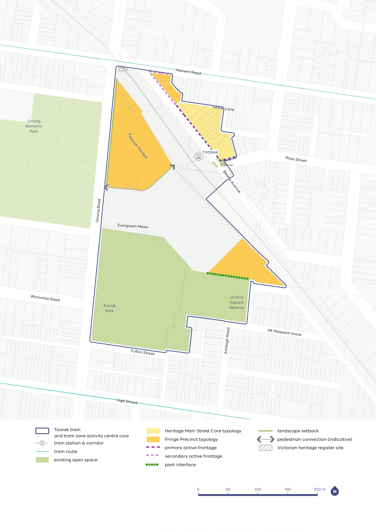
- applied primary and secondary active frontages along Beatty Avenue to encourage more commercial and pedestrian activity
- maintained the existing landscape setback along Oorong Road, to preserve the leafy, green feel of Toorak
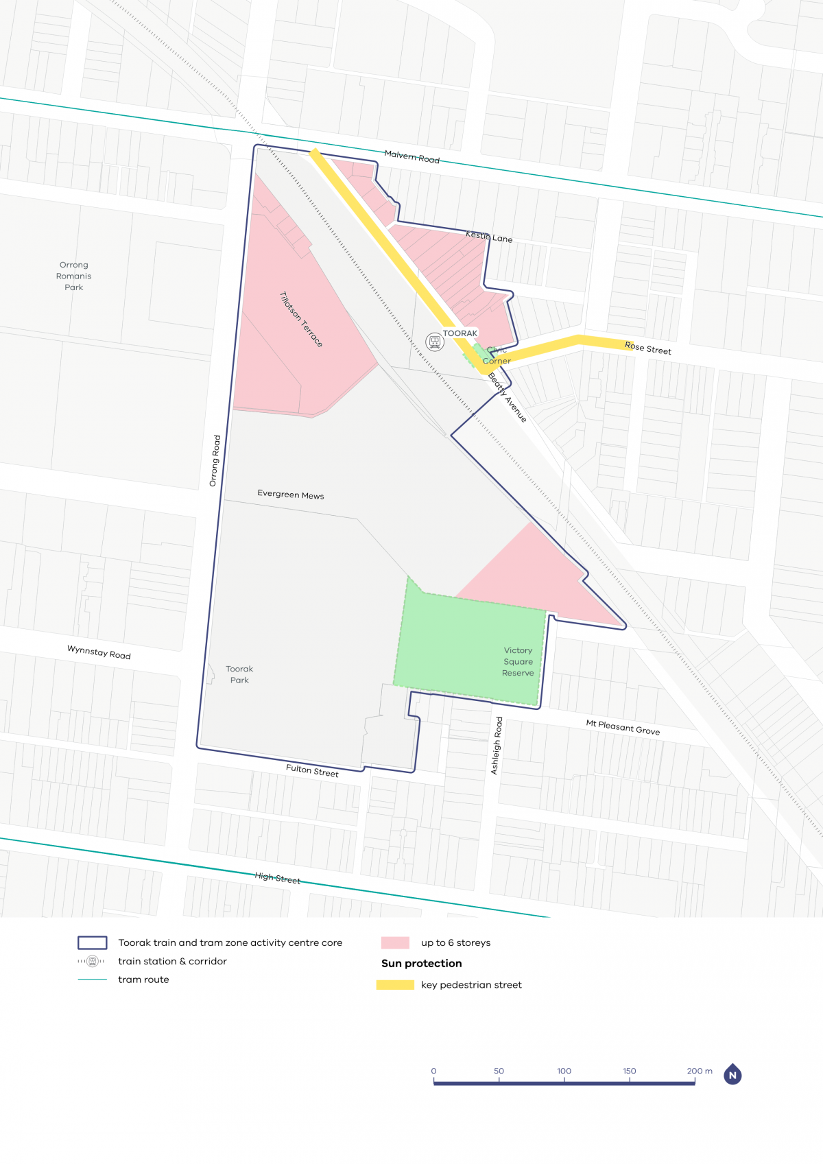
- applied lower building heights of six stories across the centre, to ensure new development supports the valued heritage character of Beatty Avenue's shopfronts and Armadale more broadly
- designated Beatty Avenue and Rose Street as key pedestrian streets with high sun protection to ensure that these streets continue to remain attractive for residents and visitors, ensuring sunlight access for those walking, resting, street dining or otherwise occupying the street.
Toorak core and catchment map
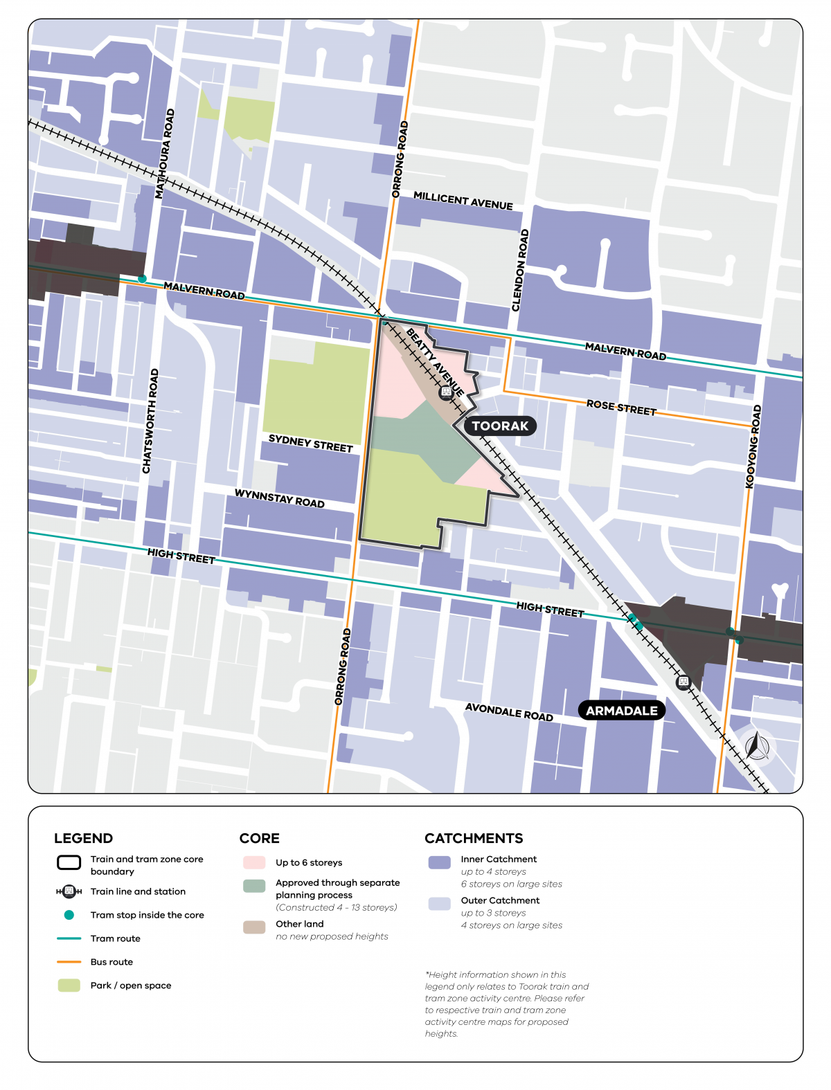
View the Hawksburn to Malvern and Toorak Village core and catchment map.
Toorak core and catchment explained
The core is the central part of the train and tram zone activity centre, closest to public transport, jobs and services. This area is best suited to accommodate more homes.
The catchment is the surrounding area within approximately 10 minutes’ walk of the core (around 800 metres).
As you move away from the commercial and community core of the train and tram zone activity centre, we expect that the proposed building heights will gradually decrease. This will allow a transition between the activity centre and the surrounding suburb.
In Toorak, residential properties on Florence Street have been removed from the catchment. This is based on community feedback regarding road access and limited development potential.
Visit the How we’re planning page to find out more about core and catchment areas, new planning tools, streamlined planning processes and the approach to delivering more homes in train and tram zone activity centres.
Activity centre plans
The built form outcomes and building heights for the activity centre core are set out on the following plans:
Plan 5: Toorak typology, activation and setbacks.
Plan 6: Toorak building heights and sun protection.
The plans support the right types of homes being built in the places they fit best.
Page last updated: 14/08/26