
Reference
On this page:
The vision for Nunawading
The following vision for Nunawading train and tram zone activity centre is built from the Statement of Advice prepared by a Community Reference Group (CRG) made up of local community members.
Nunawading will continue to be a convenient and functional place to live, strengthened by its civic facilities including The Round and the library.
Most of Nunawading’s growth will be focused along Whitehorse Road and Springvale Road in a manner that complements the existing infrastructure and train station.
Nunawading will attract new development to further enhance its day‑to‑day amenities.
The side streets of Nunawading, such as Wood Street and Mount Pleasant Road, will evolve into key pedestrian accessways supporting connections to local green spaces.
"The highest building heights should be concentrated within the commercial core areas immediately surrounding the train stations, where infrastructure, transport access, and services are already well‑established. [This] makes the most sense in these locations, as it allows higher density to be supported by public transport, retail, and existing commercial activity. This approach can accommodate growth while improving accessibility and reducing reliance on cars."
What we understand about the place and how we’ve addressed it
Nunawading is known for its mix of old and new and many people in the community support new homes in the area.
The Community Reference Group (CRG) noted how important street trees and access to sunny open spaces are for residents and visitors in Nunawading.
We heard that the community is generally supportive of greater building heights near the Whitehorse Road and Springvale Road intersection.
The CRG noted this area as being opportune for urban renewal and added commercial capacity.
This plan includes a select area of the Nunawading activity centre. It does not include the surrounding employment land which is for predominantly non‑residential uses.
As part of our work, we've applied:
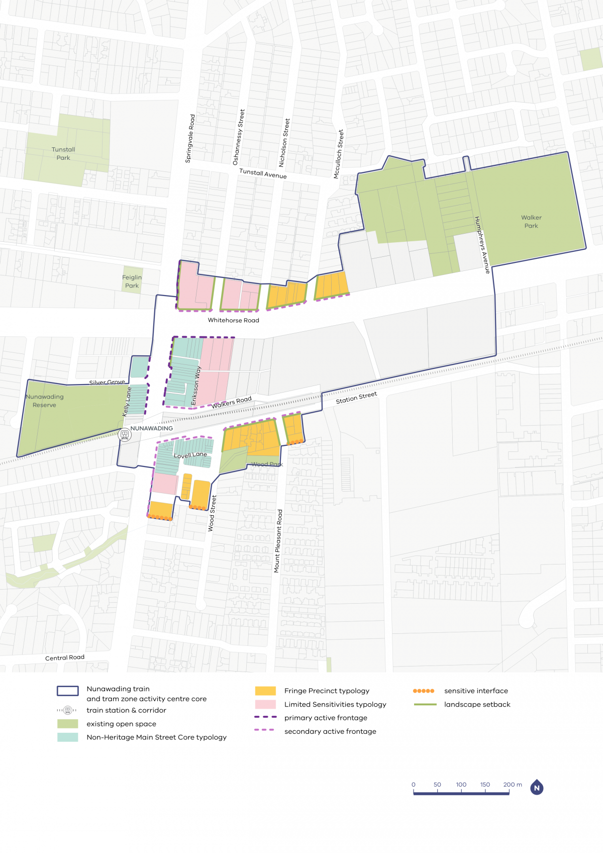
- active frontages in parts of the core, to keep the main shopping strips inviting for pedestrians
- landscape setbacks to ensure Nunawading remains green and leafy, especially on key roads that pedestrians and commuters move through
- sensitive interface setbacks to protect the residential properties around the activity centre by creating distance between developments and ensuring enough sun access
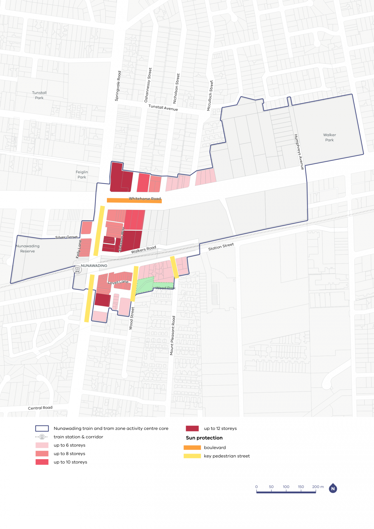
- moderate sun access to Wood Park, to ensure the existing trees and playground can continue to receive sufficient sunlight
- sun access protection to key pedestrian streets will keep these streets light and green, improving the pedestrian experience towards Wood Park.
Nunawading core and catchment map
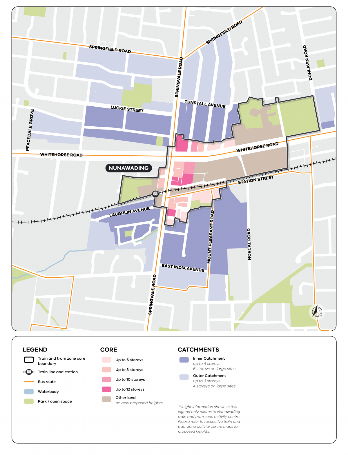
View the Blackburn to Mitcham core and catchment map.
Nunawading core and catchment explained
The core is the central part of the train and tram zone activity centre, closest to public transport, jobs and services. This area is best suited to accommodate more homes.
The catchment is the surrounding area within approximately 10 minutes’ walk of the core (around 800 metres).
As you move away from the commercial and community core of the train and tram zone activity centre, we expect that the proposed building heights will gradually decrease. This will allow a transition between the activity centre and the surrounding suburb.
In Nunawading, we’ve applied inner catchment along Springvale Road and to key development areas such as the Tunstall Village Site.
We’ve applied outer catchment around key open spaces such as Tunstall Park to the north and Erskine Walk to the south.
Any new development in the part of the catchment covered by the Gardiners Creek Significant Landscape Overlay has additional design requirements as part of that overlay.
Visit the How we’re planning page to find out more about core and catchment areas, new planning tools, streamlined planning processes and the approach to delivering more homes in train and tram zone activity centres.
Activity centre plans
The built form outcomes and building heights for the activity centre core are set out on the following plans:
Plan 5: Nunawading typology, activation and setbacks.
Plan 6: Nunawading building heights and sun protection.
The plans support the right types of homes being built in the places they fit best.
Page last updated: 02/10/26