
Reference
On this page:
The vision for Blackburn
The following vision for Blackburn train and tram zone activity centre is built from the Statement of Advice prepared by a Community Reference Group (CRG) made up of local community members.
Blackburn will continue to be a leafy, family‑friendly place with a strong sense of community and thriving local businesses.
The vegetation and landscape qualities that it is known for will be sustained and enhanced over time.
Blackburn will grow in a balanced and gradual manner that benefits from the existing local ‘village’ feel.
The centre will support a wide diversity of housing types and commercial uses, while still maintaining the characteristics of each unique area. South Parade will continue to be a destination strip with local shops and amenities, while Railway Road will be enhanced as an attractive connection for pedestrians.
"I strongly support increased density within the Blackburn Activity Centre. Well‑planned urban densification is essential for protecting the unique character of our outer residential streets while ensuring the suburb remains sustainable and accessible."
What we understand about the place and how we’ve addressed it
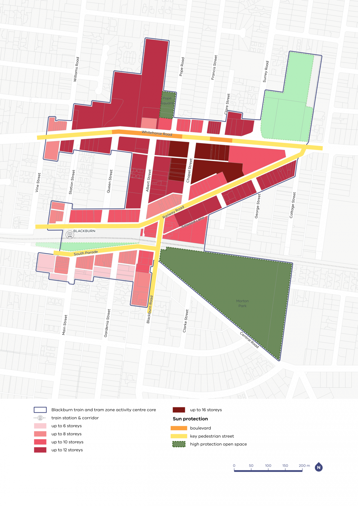
The greatest heights in Blackburn are in the central part of the activity centre core some distance from the surrounding catchment areas.
These heights are often complemented by landscape setbacks or streets that have sun access protection.
South Parade is a distinct neighbourhood destination in Blackburn due to its community-focused spaces, including local shops and cafes with outdoor dining.
The Community Reference Group noted how important greenery and tree canopy are for maintaining the liveability of Blackburn. Both are important features for the public realm and streetscapes, enhancing the pedestrian experience of the activity centre.
As part of our work, we've applied:
- the greatest heights in the centre of the core, away from the surrounding catchment area
- high sun protection at Pope Road Kindergarten and Playground, to ensure sunlight is maintained
- boulevard sun access protection to sections of Whitehorse Road with existing trees in the median
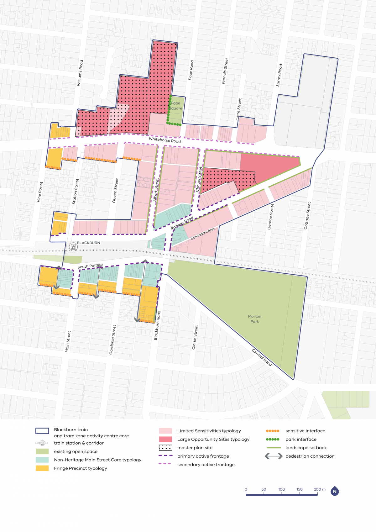
- active frontages and landscape setbacks in parts of the core, to ensure streets remain green and vibrant
- sensitive interface setbacks to protect sun access for properties to the south and ensure sufficient spacing between buildings.
Blackburn core and catchment map
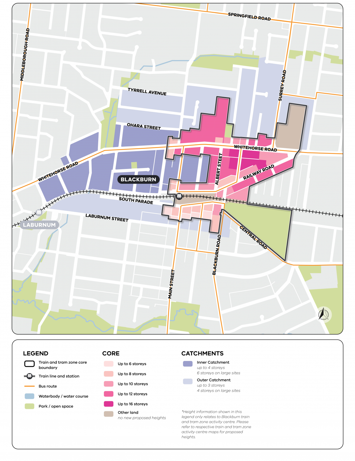
View the Blackburn to Mitcham core and catchment map.
Blackburn core and catchment explained
The core is the central part of the train and tram zone activity centre, closest to public transport, jobs and services. This area is best suited to accommodate more homes.
The catchment is the surrounding area within approximately 10 minutes’ walk of the core (around 800 metres).
As you move away from the commercial and community core of the train and tram zone activity centre, we expect that the proposed building heights will gradually decrease. This will allow a transition between the activity centre and the surrounding suburb.
In Blackburn, the greatest heights are in the centre of the core, away from the surrounding catchment area.
We’ve applied inner catchment near the Blackburn and Laburnum train stations, and along Whitehorse Road, which the community identified as a preferred location for more homes.
We’ve applied the outer catchment to areas furthest from the train station.
Visit the How we’re planning page to find out more about core and catchment areas, new planning tools, streamlined planning processes and the approach to delivering more homes in train and tram zone activity centres.
Activity centre plans
The built form outcomes and building heights for the activity centre core are set out on the following plans:
Plan 3: Blackburn typology, activation and setbacks.
Plan 4: Blackburn building heights and sun protection.
The plans support the right types of homes being built in the places they fit best.
Page last updated: 05/10/26