
Reference
On this page:
The vision for South Yarra
The following vision for the South Yarra train and tram zone activity centre is built from the Statement of Advice prepared by a Community Reference Group (CRG) made up of local community members.
South Yarra will continue to grow as an activity centre that supports residential and commercial growth in a balanced and complementary way, responding to housing and economic demand.
With strong transport links, South Yarra will offer a well-designed quality of life close to the city, while continuing to provide a vibrant mix of activities for residents and visitors. South Yarra’s unique character along Toorak Road and Chapel Street will be respected and enhanced as the activity centre embraces growth.
"The proposed distribution of building heights shown in the map appears to provide an appropriate balance between accommodating growth and responding to the surrounding urban context."
What we understand about the place and how we’ve addressed it
South Yarra has two distinct characters, between Toorak Road’s heritage shop fronts, and Forest Hill’s modern apartment and office towers. The heights in the South Yarra activity centre are reflective of this character and proximity to South Yarra Station. Heights are scaled down progressively on the east side of Toorak Road and along River Street in response to local context.
The Community Reference Group noted how important Toorak Road is as a local high street and gathering place for people to work and socialise.
We heard that the community in the South Yarra catchment area is generally supportive of development being concentrated nearest to the station and tram stops.
As part of our work, we've applied:
- increased heights on Toorak Road, closest to the South Yarra Station and Chapel Street intersection. These sites have been proposed based on their land size or their potential for consolidation with adjacent properties
- updated sun access protections on Toorak Road and Chapel Street, refining them to maintain sunlight access and a pedestrian friendly streetscape while enabling greater flexibility for development and better design outcomes.
Many areas within the South Yarra activity centre are unchanged from the existing council controls. For more information on the full range of heights permitted in South Yarra, please view the Schedule 1 in Clause 37.08 of the Stonnington Planning Scheme.
South Yarra core and catchment map
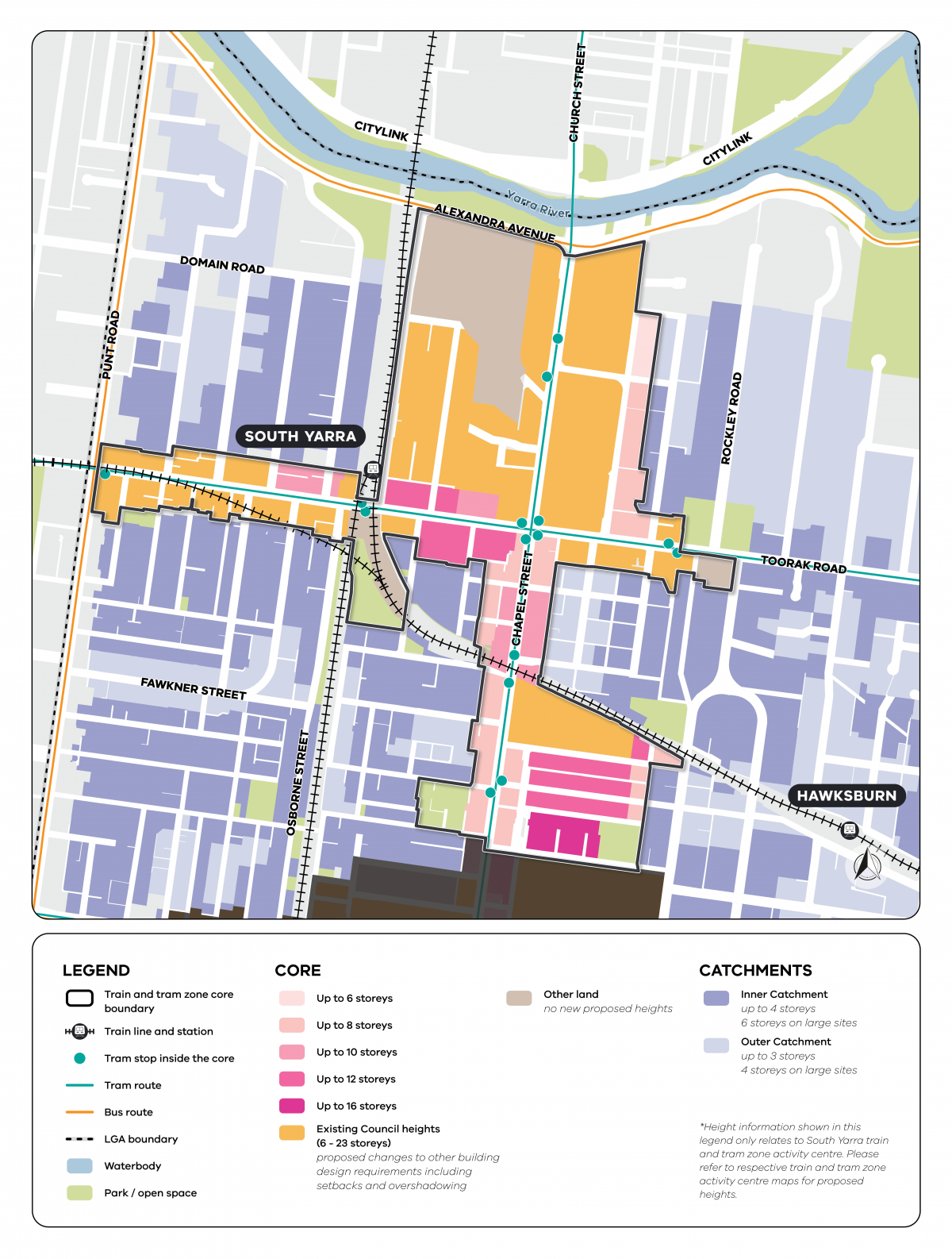
View the South Yarra to Windsor core and catchment map.
South Yarra core and catchment explained
The core is the central part of the train and tram zone activity centre, closest to public transport, jobs and services. This area is best suited to accommodate more homes.
The catchment is the surrounding area within approximately 10 minutes’ walk of the core (around 800 metres).
As you move away from the commercial and community core of the train and tram zone activity centre, we expect that the proposed building heights will gradually decrease. This will allow a transition between the activity centre and the surrounding suburb.
In South Yarra, the catchment ends before it intersects with Yarra (Birrarung) River Corridor Environs Significant Landscape Overlay.
Visit the How we’re planning page to find out more about core and catchment areas, new planning tools, streamlined planning processes and the approach to delivering more homes in train and tram zone activity centres.
Activity centre plan
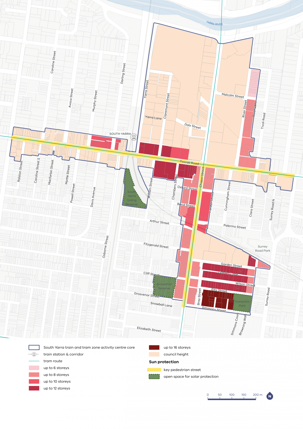
The built form outcomes and building heights for the activity centre core are set out on the following plan:
Plan 3: South Yarra building heights and sun protection.
Solar controls will apply to the south of all east-west streets and other forms of open spaces as per the Activity Centre Zone. For more information on where all sun protection controls apply please see the Stonnington Planning Scheme.
The plan supports the right types of homes being built in the places they fit best.
Page last updated: 14/08/26