
Reference
On this page:
The vision for Ormond
The following vision for the Ormond train and tram zone activity centre is built from the Statement of Advice prepared by a Community Reference Group (CRG) made up of local community members.
Embracing its local character, Ormond will continue to support daily needs close to home, with shops, services and employment located within walking distance of public transport services. This reinforces its role as a smaller, but still well-functioning centre.
North Road will continue to have a dual role as a key transport route and a lively main street. Good quality development will create streets that feel safe, intuitive and comfortable, while strengthening the relationship between buildings, movement and public space.
Higher density living and the existing dual access entrances to Ormond Station will help unlock the centre’s potential, creating a well-connected place that supports everyday life.
Future growth will build on Ormond’s recognised character, with built form that reinforces a coherent and distinctive centre over time.
"The neighbourhoods around Ormond Station are predominantly low rise, leafy, family‑orientated and full of character. It is a small station supported by a vibrant and diverse local community. This is what makes living in this area great."
What we understand about the place and how we’ve addressed it
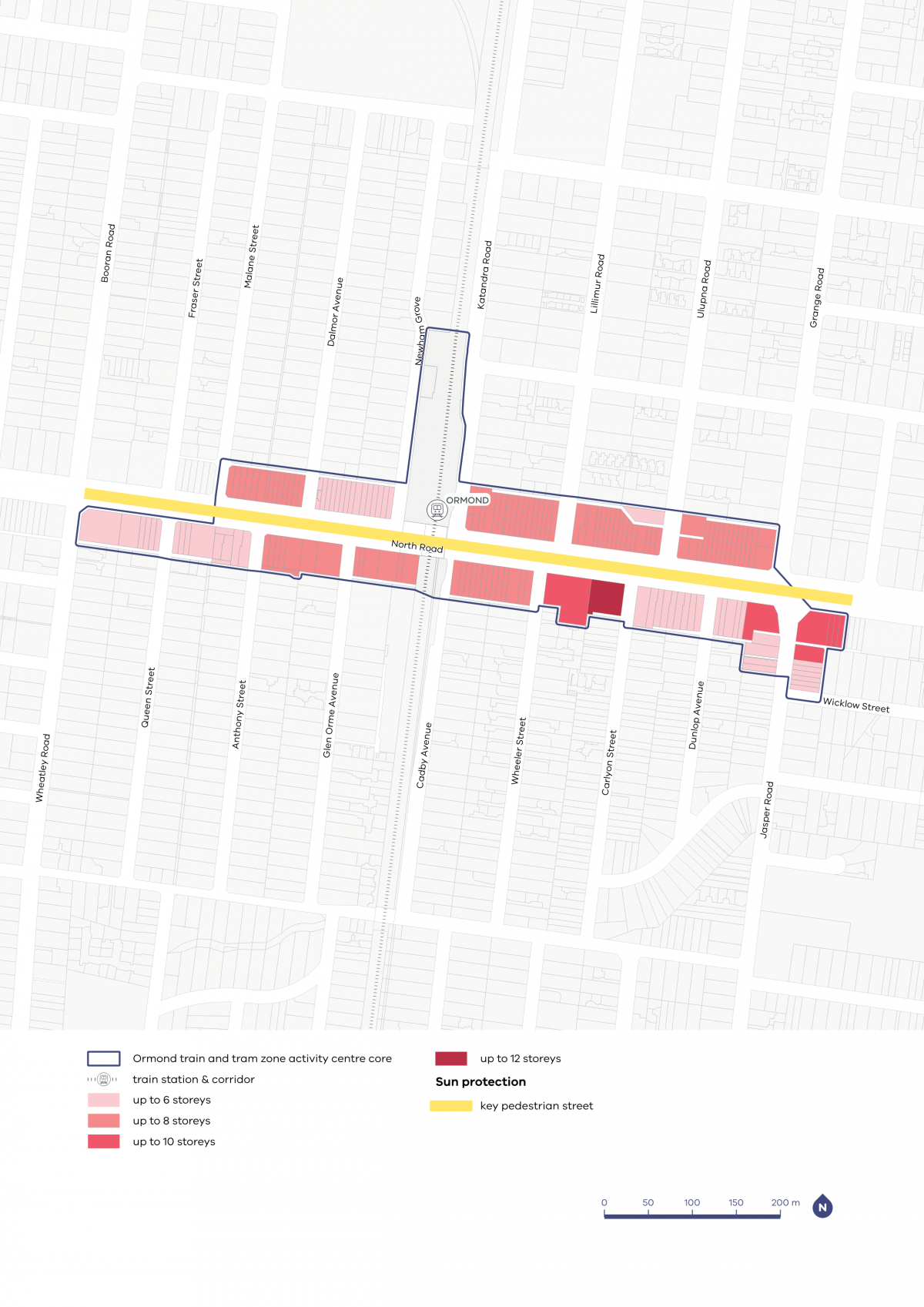
Ormond is known for its proximity to local schools, a diverse mix of shops and services and a range of housing types from single storey dwellings, to modern apartments and townhouses. This is why we are supporting the emerging character of the area by encouraging more housing along North Road and encouraging a range of heights from six to 12 storeys, where appropriate. This approach will expand the range of housing options available, to meet the changing needs of existing and future residents.
There is an opportunity to enhance the public realm within this centre to support the existing and future mix of commercial shops, services and housing. Active frontages along North Road will also help promote street-level activity, increasing amenity and feelings of safety.
The Community Reference Group noted general acceptance of heights in the right locations, and that more development around North Road could reinvigorate the area if designed well.
We heard that the community is generally supportive of more housing in the area, recognising its role in strengthening the viability of North Road and in attracting a range of desirable commercial businesses to the centre.
As part of our work, we’ve applied:
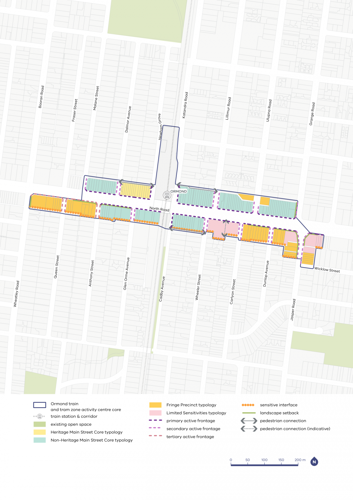
- primary active frontages to North Road, to encourage more vibrancy to the streetscape
- key pedestrian street designation along North Road to maintain sun access
- building heights of six to 12 storeys to the core, acknowledging the community’s support for development here
- requirements for landscape setbacks along North Road, to increase greening and tree canopy coverage while improving pedestrian comfort and safety next to a high traffic road.
Ormond core and catchment map
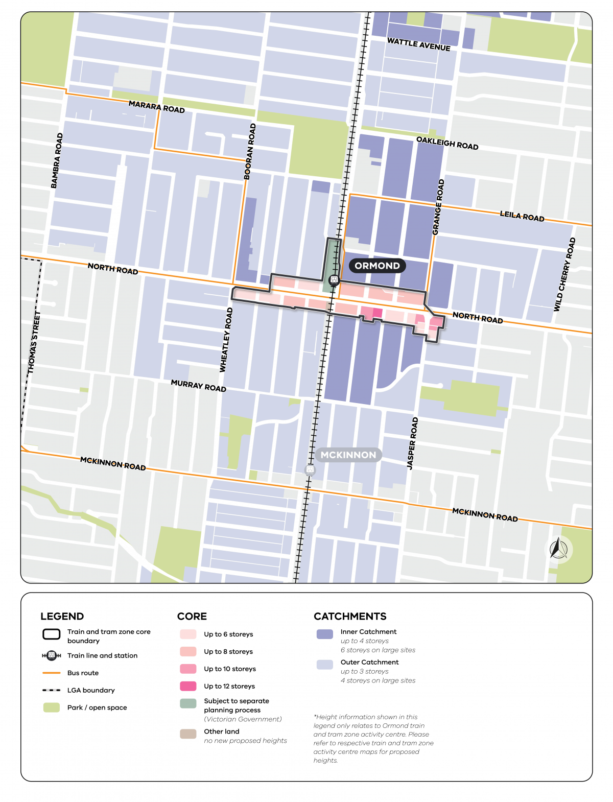
View the Caulfield to Bentleigh and Elsternwick core and catchment map.
Ormond core and catchment explained
The core is the central part of the train and tram zone activity centre, closest to public transport, jobs and services. This area is best suited to accommodate more homes.
The catchment is the surrounding area within approximately 10 minutes’ walk of the core (around 800 metres).
As you move away from the commercial and community core of the train and tram zone activity centre, we expect that the proposed building heights will gradually decrease. This will allow a transition between the activity centre and the surrounding suburb.
In Ormond, the inner catchment responds to EE Gunn Reserve and existing bus services across the area.
The outer catchment responds to Wattle Grove Reserve and Joyce Park.
Visit the How we’re planning page to find out more about core and catchment areas, new planning tools, streamlined planning processes and the approach to delivering more homes in train and tram zone activity centres.
Activity centre plans
The built form outcomes and building heights for the activity centre core are set out on the following plans:
Plan 7: Ormond typology, activation and setbacks.
Plan 8: Ormond building heights and sun protection.
The plans support the right types of homes being built in the places they fit best.
Page last updated: 02/10/26