
Reference
On this page:
The vision for Glen Huntly
The following vision for the Glen Huntly train and tram zone activity centre is built from the Statement of Advice prepared by a Community Reference Group (CRG) made up of local community members.
Glen Huntly will continue to function as a vibrant centre, where active ground floor uses, local businesses and higher density development are encouraged to build on a welcoming environment that is well-supported by public transport.
Built form controls that encourage pedestrian activity and protects sunlight to key public spaces will help create an inviting centre, enhance street presence, support movement and establish a strong sense of place at the pedestrian level.
Booran Reserve will continue to play an important role as a key open space, valued for its amenity and contribution to recreation and community wellbeing. Glen Huntly’s open space and greenery will ensure Glen Huntly evolves with balance and long-term amenity.
"Glen Huntly is already a great example of an activity centre. It has a lively, multicultural high street with high rise apartments very close to the station that taper as you move away. It has fantastic public transport connections."
What we understand about the place and how we’ve addressed it
Glen Huntly is known for its cafes, restaurants and local businesses along Glen Huntly Road, where residents and visitors spend time, creating a lively and welcoming atmosphere.
Booran Reserve is also a popular family-friendly park that provides a shared outdoor space for the community, supporting recreation, social interaction and activities for people of all ages.
The Community Reference Group noted how important development is to rejuvenate the core shopping street and how density should be focused along the main street for Glen Huntly.
We heard that community is generally supportive of greater heights on the main street and key intersections, as well as setting buildings back further from the street and gradual transitions of height.
As part of our work, we've applied:
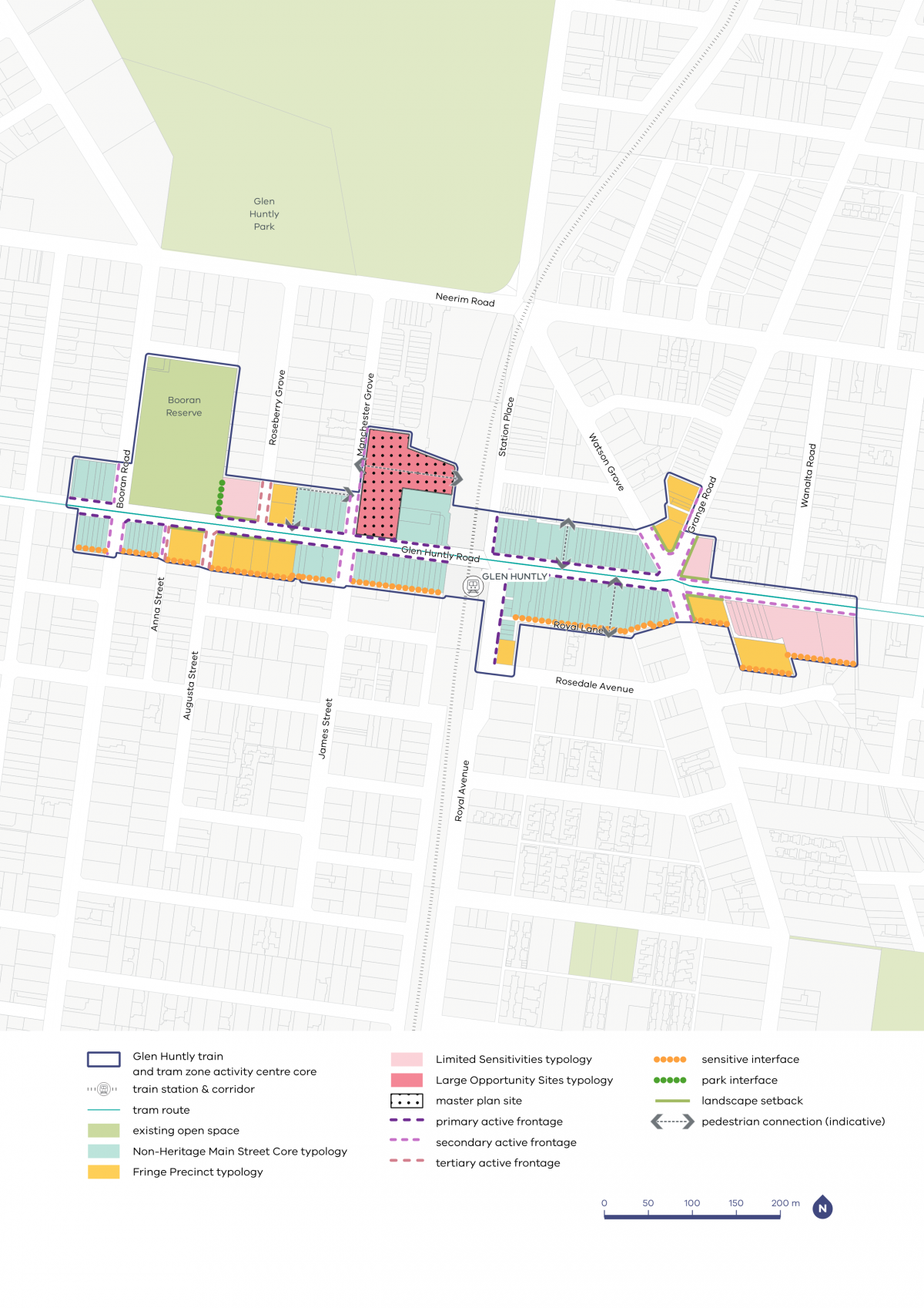
- primary and secondary active frontages along Glen Huntly Road to help maintain its vibrancy and improve its main street function
- landscape setbacks to places such as Watson Grove and sections of Glen Huntly Road, to preserve and enhance the streetscape and tree canopy
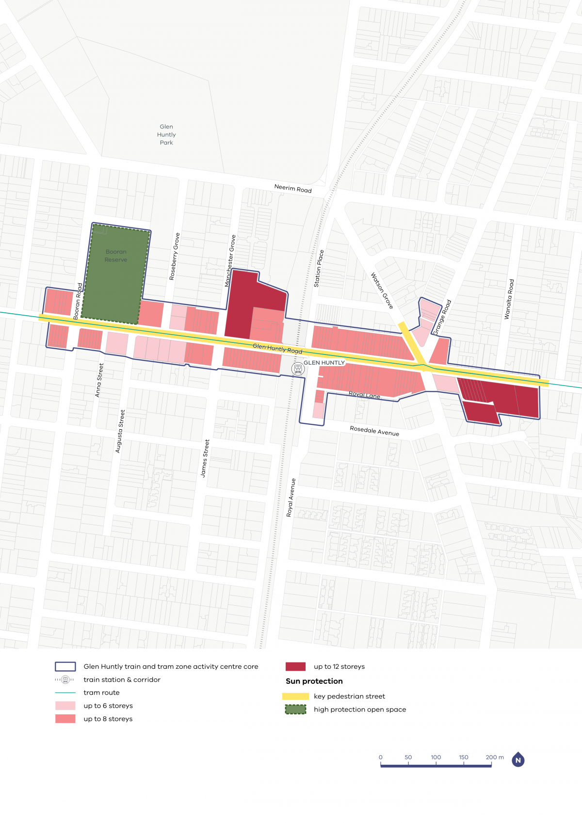
- up to 12 storey heights in some areas along Glen Huntly Road, as higher density is preferred in this area
- the highest level of overshadowing protection to Booran Reserve, as this is an important open space to the community
- high solar access protection along Glen Huntly Road to support future growth of trees and maintain daylight access for the community.
Glen Huntly core and catchment map
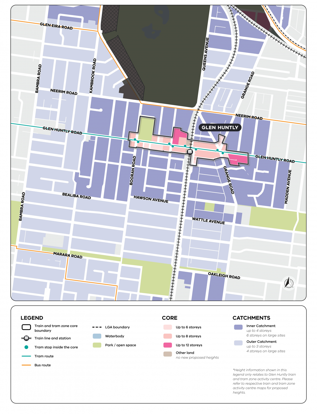
View the Caulfield to Bentleigh and Elsternwick core and catchment map.
Glen Huntly core and catchment explained
The core is the central part of the train and tram zone activity centre, closest to public transport, jobs and services. This area is best suited to accommodate more homes.
The catchment is the surrounding area within approximately 10 minutes’ walk of the core (around 800 metres).
As you move away from the commercial and community core of the train and tram zone activity centre, we expect that the building heights will gradually decrease. This will allow a transition between the activity centre and the surrounding suburb.
In Glen Huntly, the inner catchment responds to the 67 tram, Glen Huntly Road, train station services and bus routes along Neerim Road.
The outer catchment responds to Lord Reserve and existing tram and bus routes.
Visit the How we’re planning page to find out more about core and catchment areas, new planning tools, streamlined planning processes and the approach to delivering more homes in train and tram zone activity centres.
Activity centre plans
The built form outcomes and building heights for the activity centre core are set out on the following plans:
Plan 5: Glen Huntly typology, activation and setbacks.
Plan 6: Glen Huntly building heights and sun protection.
The plans support the right types of homes being built in the places they fit best.
Page last updated: 02/10/26