
Status
On this page:
New to practice notes?
Planning practice notes give technical advice about the planning system, each dealing with separate aspects of the system.
This practice note provides guidance on:
- managing coastal hazards
- the decision-making process for assessing coastal hazard risk
- planning for development in coastal areas.
Background
Victoria has over 2,500 km of coastline, including extensive:
- sandy beach systems
- rocky coasts
- bays
- inlets and estuaries
- coastal lakes
- floodplains.
These are dynamic environments shaped by natural coastal processes. Traditional Owners have cared for these diverse landscapes for countless generations.
Significant development has already occurred in many coastal areas. Population growth and the demand for coastal living create ongoing pressures. At times, coastal processes may have a negative impact on coastal values and uses. These processes include:
- erosion
- inundation
- accretion
- other physical/chemical processes.
What is a coastal hazard?
In this practice note, coastal hazard refers to coastal inundation and erosion and riverine flooding.
Coastal hazards may also include estuary dynamics, offshore sediment dynamics, saline groundwater intrusion.
Coastal hazard exposure occurs periodically across the coast and is projected to increase with changes in wave action, storm activity and sea level rise associated with climate change.
Coastal flooding
Coastal flooding can occur along all low-lying areas of the coast. Flooding in coastal areas can include the following elements.
- Coastal inundation (inundation from the sea, mainly from storm surge and tides), including:
- Storm-tide inundation: Temporary event-based inundation from the sea
- Permanent inundation: Regular or persistent inundation by the regular tidal cycle.
- Riverine flooding (flooding from catchment rainfall and drainage): Heavy rainfall produces surface run-off which flows into streams and rivers. When there is a large amount of run-off, water overflows the riverbanks on to adjacent low-lying land causing flooding. This is called riverine flooding and can occur in both rural and urban areas.
In coastal areas, riverine flooding may combine with coastal inundation from the sea, increasing the extent of coastal flooding. This is also referred to as ‘co-incident flooding’. Rivers and drainage systems may become swollen, and water levels will rise until the inflows match the outflows into the sea. Flooding from the sea can also backup through the connecting rivers and drains.
The frequency, extent and magnitude of coastal flooding is likely to be altered by climate change over time including through the combined interactions with sea level rise, hightides, storm surges and other coastal processes.
The Land Subject to Inundation Overlay (LSIO) can identify areas affected by coastal flooding in planning schemes.
Coastal erosion
Coastal erosion is a naturally occurring process of sediment shifting away from localised areas of the coast (offshore or alongshore). Erosion can occur across sandy, rocky and tidal environments, and is influenced by a range of factors including coastal processes, climate change and land use.
Erosion can be either long term or short term.
- Long-term coastal erosion: A trend of erosion extending over several years resulting in recession (retreat) of the shoreline position. This can be caused by a range of factors including changes in climate and sediment supply (where sediment is moved along the shore by wave action).
- Short-term coastal erosion: Erosion that can occur over a short period of time as a result of extreme weather events (also termed ‘storm bite’). This may result in a short-term eroding of the beach profile as sand is transported offshore/alongshore. In calmer conditions, wind and waves act to transport sand back onshore again to rebuild the beach and dunes. While this type of erosion can sometimes be significant, the average shoreline position remains similar over longer timeframes.
Other natural hazards
Other natural hazards, such as bushfire, acid sulfate soils, extreme heat, drought, subsidence and landslip, as well as issues such as water quality and groundwater changes also occur in the coastal zone and need to be considered in planning and building processes.
Climate change and coastal hazards
Climate change is likely to increase the intensity and extent of existing coastal hazards.
This means that for some parts of the Victorian coast climate change impacts are likely to exacerbate coastal erosion and flooding, potentially further increasing the impacts of these coastal hazards on existing and future coastal communities, development and the natural environment.
Planning should account for impacts such as sea level rise that is gradual and will occur over a long timeframe, as well as extreme weather events that can occur at any time and can significantly reshape the coastline, using best available technical data and advice.
Ministerial Direction No. 13 - Managing Coastal hazards and the Coastal Impacts of Climate Change sets out requirements for considering the impacts of climate change within coastal Victoria through the planning scheme amendment process.
Sea level rise planning benchmark
The Marine and Coastal Policy (Department of Environment, Land, Water and Planning, March 2020) sets out the policy and strategic direction for responding to coastal hazard risks in the context of climate change. It identifies the need to:
Plan for sea-level rise of not less than 0.8 metres by 2100, and allow for the combined effects of tides, storm surges, coastal processes and local conditions such as topography and geology when assessing risks and impacts associated with climate change.
The Marine and Coastal Policy is reflected in clause 13.01-2S (coastal inundation and erosion) of the planning scheme. The Policy enables planning for levels greater than 0.8 metres sea-level rise by 2100. Detailed local and regional coastal hazard assessments and advice from the relevant floodplain management authority support local variations.
Strategic planning and rezoning for urban purposes in coastal areas
It is important to avoid future development or intensification in coastal areas outside of existing settlements that are likely to be impacted by projected coastal hazards. Where development is appropriate, it should be sited and designed in a way that protects future communities and assets from coastal hazard risk.
A proposal to rezone land may be informed by an existing coastal hazard assessment, a coastal vulnerability assessment for that part of the coastline, or inundation advice from a floodplain manager. Guidelines on how to prepare a coastal hazard assessment are accessible on the DELWP Marine and Coasts website.
Strategic investigations should consider:
- the Marine and Coastal Act 2018 guiding principles, including the precautionary principle
- the values, uses and objectives for the area
- the local geographic characteristics of the coastline such as ocean exposure (for example open coast or sheltered exposure) and land type (such as sandy, rocky, engineered)
- the role of natural coastal processes and the need to allow for such processes to continue as a cost-effective form of coastal defence against climate change
- the coastal hazard vulnerability and risk for all relevant site values and uses, including:
- probability, magnitude, frequency and consequences
- impacts on people, property, communities, infrastructure and environment
- the intended use, design lifespan and value of future development, assessed against the relative risk exposure during that time
- the adaptation options for managing coastal hazard set out in the Marine and Coastal Policy (Department of Environment, Land, Water and Planning, 2020) comprising: non-intervention, avoid, nature-based, accommodate, retreat and protect.
- the critical need for coastal protection infrastructure (if the ‘protect’ pathway is required) and:
- the type, location and cost of providing and maintaining such infrastructure throughout its intended lifespan
- proposed actions when the design lifespan has been spent
- the need for all-weather access during times of emergency for future communities
- appropriate built form responses to avoid a projected permanent hazard event or withstand a temporary event such as the need for:
- setbacks
- particular materials
- a particular sub-floor structure or floor level
- the cumulative impact or any flow-on effects of future use and development and any necessary associated protection works to adjacent properties and the coastline
- other identified geotechnical risks or natural hazards such as coastal acid sulfate soils, land subsidence, bushfire
- any other issues relative to the orderly and proper management of use and development within coastal areas such as development within an identified settlement boundary, significant landscapes, native vegetation and cultural heritage
- Traditional Owner rights and assertions as per the Marine and Coastal Policy (Department of Environment, Land, Water and Planning, 2020).
Strategic investigations should also consider other future management issues that may be relevant to ensure risk minimisation and effective long-term management of use and development.
Assessing development proposals
Floodplain manager referrals
The Water Act 1989 provides that a designated floodplain management authority has a responsibility to:
- control development that may be proposed on land adjoining waterways
- to develop and implement plans to take any action necessary to minimise flooding and flood damage
- provide advice to local councils about flooding and controls on development proposals.
The Building Regulations 2018 also include flood-related responsibilities for a council, such as the setting of minimum floor levels in consultation with the relevant floodplain management authority and the assessment of the flood risk of a site.
A statutory referral to the floodplain management authority (relevant catchment management authority (CMA) or Melbourne Water) is currently required where the following apply:
- Urban Floodway Zone (UFZ)
- Land Subject to Inundation Overlay (LSIO)
- Floodway Overlay (FO)
- Special Building Overlay (SBO).
Their expert input can address issues such as facilitating the free passage of floodwaters and protecting buildings from floods and storm surges by establishing appropriate floor levels or mitigation measures.
Clause 65 of the planning scheme extends consideration of flood issues to all planning permit applications, regardless of whether the site is affected by a flood zone or overlay. Therefore, a responsible authority may also seek informal technical advice from a floodplain management authority on a planning permit application in coastal areas outside of these flood overlays. A council is encouraged to seek advice, where necessary, from the relevant floodplain management authority under section 52 of the Planning and Environment Act 1987.
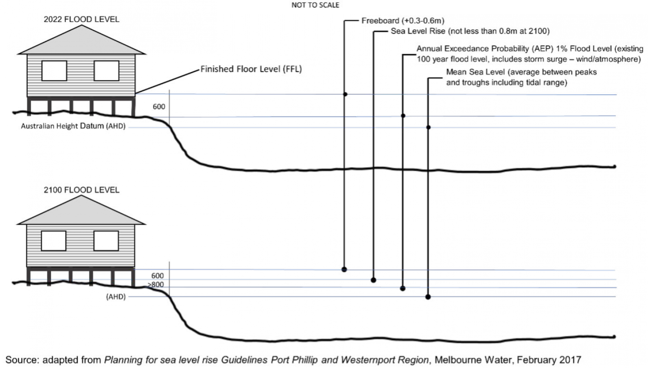
The diagram at Figure 1 below outlines the kind of information a floodplain management authority uses to advise on finished floor levels in coastal areas (indicative only).
For further advice on managing coastal hazards in development proposals refer to:
- Planning for sea level rise (Melbourne Water)
- Guidelines for Development in Flood Affected Areas (Department of Environment, Land, Water and Planning, 2019)
Coastal vulnerability assessments
A coastal vulnerability assessment may assist a council to inform decision making outside an existing settlement or urban zoned area. This is usually undertaken by a qualified coastal engineer or coastal processes specialist, who can assist with understanding erosion rates and developing appropriate setbacks or protection works. In some instances, where local geology may be unknown or unstable, or where flooding from rivers and streams may also be an issue, advice can also be sought from a qualified hydrological or geotechnical expert.
Planning permit decisions should be made using the best available knowledge and information at the time. An assessment of coastal vulnerability is important when deciding whether a proposed use or development should be supported and should not be deferred for secondary consent. Section 173 agreements should also not be applied to individual properties to defer hazards being considered as part of any planning permit application.
Additional resources
For further information relevant to coastal adaptation planning see:
Coastal adaptation planning
The Coast and Planning in Victoria
The Marine and Coasts at marineandcoasts.vic.gov.au
The Marine and Coastal Act 2018 at legislation.vic.gov.au
The Marine and Coastal Policy (Department of Environment, Land, Water and Planning, March 2020)
The Marine and Coastal Strategy (Department of Environment, Land, Water and Planning, May 2022)
Victoria's Marine and Coastal Reforms - Final Transition Plan (Department of Environment, Land, Water and Planning, 2018) at marineandcoasts.vic.gov.au.
The Port Phillip Bay Coastal Hazard Assessment at marineandcoasts.vic.gov.au
Victoria’s Resilient Coast – Adapting for 2100+ at marineandcoasts.vic.gov.au
Local Coastal Hazard Assessments (LCHAs)
Local Coastal Hazard Assessments (LCHAs) - LCHAs are available for Port Fairy, Bellarine -Corio Bay, Gippsland Lakes and Ninety Mile Beach, Western Port and the Inverloch region at marineandcoasts.vic.gov.au. (In some areas where a completed coastal hazard assessment is not yet available, CMAs and councils may apply local information appropriate for future planning and decision-making).
Victorian Government’s climate change program
Climate Action at climatechange.vic.gov.au
Victorian Marine and Coastal Council at marineandcoasts.vic.gov.au
Built Environment Climate Change Adaptation Action Plan 2022-2026 (Department of Environment, Land, Water and Planning, 2022)
Sea level rise impacts along the Victorian coast
Victorian Coastal Inundation Dataset (DELWP) at discover.data.vic.gov.au
Victorian Coastal Hazard Guide (Department of Sustainability and Environment, 2012)
Erosion processes data resources along the Victorian coast
Victorian Coastal Monitoring Program at marineandcoasts.vic.gov.au
Glenelg-Hopkins Catchment Management Authority
(03) 5571 2526
Postal Address
PO Box 502
Hamilton VIC 3300
Hamilton office
79 French Street
Hamilton VIC 3300
Corangamite Catchment Management Authority
1800 002 262
Postal Address
PO Box 159
Colac VIC 3250
Colac office
64 Dennis Street
Colac VIC 3250
Geelong office
54A Corio Street
Geelong VIC 3220
Melbourne Water
Melbourne Water is the floodplain management authority for the whole of the Port Phillip and Westernport region
131 722
Postal Address
PO Box 4342
Melbourne 3001
Corporate office
990 La Trobe Street
Docklands 3008
West Gippsland Catchment Management Authority
1300 094 262
Postal Address
PO Box 1374
Traralgon VIC 3844
Traralgon office
16 Hotham Street
Traralgon VIC 3844
Leongatha office
Corner Young and Bair Streets
Leongatha VIC 3953
East Gippsland Catchment Management Authority
(03) 5152 0600
Postal Address
PO Box 1012
Bairnsdale VIC 3875
East Gippsland office
574 Main Street
Bairnsdale VIC 3875
Disclaimer
This publication may be of assistance to you but the State of Victoria and its employees do not guarantee that the publication is without flaw of any kind or is wholly appropriate for your particular purposes and therefore disclaims all liability for any error, loss or other consequence which may arise from you relying on any information in this publication.
Page last updated: 14/03/24